Abstract
Madagascar regularly faces disasters and health emergencies. It is one of the countries vulnerable to various disaster risks and climate change. Since 2014, the country has been affected by large-scale epidemics and natural disasters. In order to strengthen prevention, preparedness, response, and resilience to health threats, the World Health Organization (WHO) recommends that countries conduct a health risk assessment and mapping as the first step in the emergency management cycle in the context of limited resources and update the risk profile every three years. The objectives are to identify and characterize the various priority health risks in Madagascar, assess the probability of their occurrence, estimate their potential impact, determine the estimated level of risk, categorize them, and map them in order to formulate key recommendations. This is a qualitative, multisectoral, and multi-hazard assessment, combined with national health risk mapping using the WHO's Strategic Tool for Assessing Risk (STAR). The first assessment was conducted in 2022, followed by an update of the health risk profile in 2025. The results obtained in 2022 identified 23 health threats out of the 96 identified. In 2025, during the update, 21 threats were retained, including 3 threats that were removed.
|
Published in
|
American Journal of Health Research (Volume 14, Issue 4)
|
|
DOI
|
10.11648/j.ajhr.20261404.14
|
|
Page(s)
|
204-218 |
|
Creative Commons
|

This is an Open Access article, distributed under the terms of the Creative Commons Attribution 4.0 International License (http://creativecommons.org/licenses/by/4.0/), which permits unrestricted use, distribution and reproduction in any medium or format, provided the original work is properly cited.
|
|
Copyright
|
Copyright © The Author(s), 2026. Published by Science Publishing Group
|
Keywords
Health risk, Assessment, Mapping, WHO Strategic Tool for Assessing Risk, Madagascar
1. Introduction
The scale and complexity of health and humanitarian emergencies continues to expand. Between 2011 and 2016, WHO reported over 1.000 epidemics across 168 countries.
| [1] | World Health Organization. Strategic toolkit for assessing risks: a comprehensive toolkit for all-hazards health emergency risk assessment. Geneva: WHO; 2021. Licence: CC BY-NC-SA 3.0 IGO. |
[1]
. Madagascar has recorded nearly 50 natural disasters affecting more than 11.5 million people over the past 36 years. Since 2014, the country has faced several major epidemics, including outbreaks of pneumonic plague, measles, polio, the COVID-19 pandemic, and a resurgence of malaria cases. Due to its climate profile and geographical location, Madagascar is regularly exposed to disasters and health emergencies. The country is therefore considered extremely vulnerable to various disaster risks and climate change.
| [2] | Bureau National de Gestion des Risques et des Catastrophes. Plan de contingence multi-risques du gouvernement et du comité permanent inter-agences 2015-2016. Madagascar: BNGRC; 2015. |
| [3] | Ministère de la Santé publique. Plan de Développement du Secteur Santé 2020-2024. Madagascar: MSANP; 2020. |
[2, 3]
. In order to minimize the health risks and consequences of all types of emergencies and disasters, countries and communities are recommended to adopt a risk-based approach to emergency management
| [1] | World Health Organization. Strategic toolkit for assessing risks: a comprehensive toolkit for all-hazards health emergency risk assessment. Geneva: WHO; 2021. Licence: CC BY-NC-SA 3.0 IGO. |
[1]
. Risk assessment is a process of determining risks to be prioritized for risk management, by the combination of risk identification, risk analysis, and evaluation of the level of risk against predetermined standards, targets, risks or other criteria.
| [4] | World Health Organization. Glossary of Health Emergency and Disaster Risk Management Terminology. Geneva: WHO; 2020. Licence: CC BY-NC-SA 3.0 IGO. |
[4]
. The Sendai Framework for Disaster Risk Reduction also emphasizes its importance as a key step in preventing new disasters and mitigating existing ones
| [5] | Nations Unies. Cadre d'action de Sendai pour la réduction des risques de catastrophe 2015-2030. |
[5]
. The joint external evaluation of national capacities for the International Health Regulations 2005 (IHR 2005) recommends that countries carry out risk profiling, assessment, and mapping in order to develop a National Action Plan for Health Security (NAPHS)
| [6] | Organisation Mondiale de la Santé. Un PANSS pour tous: Cadre stratégique en trois étapes relatives au Plan d’action national pour la sécurité sanitaire (PANSS). Genève: OMS; 2019 (WHO/WHE/CPI/2018.52). Licence: CC BY NC SA 3.0 IGO. |
| [7] | Organisation mondiale de la Santé. Évaluation externe conjointe des principales capacités RSI de la République de Madagascar. Genève: OMS; 2017 (WHO/WHE/CPI/REP/2017.66). License: CC BY-NC-SA 3.0 IGO. |
[6, 7]
. In resource-limited settings, it is essential to prioritize emergency and disaster management interventions based on evidence. Therefore, risk identification and assessment are the first steps in the health emergency management cycle
| [1] | World Health Organization. Strategic toolkit for assessing risks: a comprehensive toolkit for all-hazards health emergency risk assessment. Geneva: WHO; 2021. Licence: CC BY-NC-SA 3.0 IGO. |
[1]
.
The objectives are to identify and characterize the various priority health risks in Madagascar, assess the probability of their occurrence, estimate their potential impact, determine the estimated level of risk, categorize them, and map them with a view to formulating key recommendations for strengthening prevention, preparedness, response, and resilience to health risks.
2. Materials and Methods
This is an assessment exercise and health risk mapping conducted in 2022 and then updated in 2025 at the national level with the involvement of the 23 Madagascar's regions.
It is a qualitative, participatory, and multisectoral approach. Through a discussion-based consensus-building process that references existing data and emergency response experience, multisectoral experts come together identify hazards that may warrant a national response effort, the likelihood of each hazard to occur, and the hazard’s potential impact.
The two exercises in 2022 and 2025 involved around 100 multisectoral participants in the One Health platform alongside other sectors.
Figure 1. Summary of strategic risk assessment using STAR.
The WHO's STAR tool was used to conduct a strategic assessment of health risks in Madagascar. The tool has been validated through 64 pilot workshops and a global consultation hosted by the WHO Region of the Americas in November 2019. It is an advanced Excel spreadsheet capable of automatically generating a risk classification based on defined assessment parameters and the level of confidence associated with the availability and quality of data and evidence. The tool can be used to describe any type of risk at all levels of the healthcare system. While the STAR process does not replace other more rigorous methods of predicting risk within the country, such as those involving advanced mathematical modelling; it does provide an easily adaptable all-hazards approach that enables the consolidation of available evidence and exchange of national and subnational emergency management experience among multisectoral experts.
A strategic risk assessment uses a step-by-step process to describe risks within a specified geographic area to develop an emergency risk profile.
The STAR approach involves key steps below including:
1) Identify country hazard(s) and describe the most likely scenario to require activation of national response
2) Assess the likelihood of the risk occurring
3) Estimate the impact of the risk to the country
4) Determine the estimated level of risk
5) Integrate recommendations and priority actions based on the risk ranking (
Figure 1).
6) The expected output from a STAR is a country risk profile, which includes:
7) A risk matrix (Ranking risks visually on a 5x5 matrix, describing likelihood and impact of the hazard)
8) A risk summary (Describing health consequences, scale of the hazard and identified population at risk, frequency of occurrence, likelihood to occur, seasonality, severity, vulnerability, coping capacity, potential impact, and confidence level in data available)
9) Overall workshop report that consolidates the risk matrix, risk summary, as well as initial short-term prioritized action planning
| [1] | World Health Organization. Strategic toolkit for assessing risks: a comprehensive toolkit for all-hazards health emergency risk assessment. Geneva: WHO; 2021. Licence: CC BY-NC-SA 3.0 IGO. |
[1]
.
2.1. Identifying Country Hazard
The first step of conducting a strategic risk assessment is to identify the hazards that are relevant to be assessed in the context of Madagascar. It is based on: previous risk assessments, reference information from surveillance reports, capacity assessment reports and official databases, hazards from neighboring countries or global level and WHO Classification of Hazards which provides a comprehensive overview of biological, hydro-meteorological, extra-terrestrial, technological, societal and environmental hazards
| [8] | Organisation Mondiale de la Santé. Cadre de gestion des risques liés aux situations d’urgence et aux catastrophes dans le contexte de la santé. Genève: OMS; 2021. Licence: CC BY-NC-SA 3.0 IGO. |
[8]
. The prioritized selection is based on the most likely scenario to trigger the activation of coordinated response.
Subsequently, the potential negative health consequences of each selected hazard were examined. These are defined as the downstream effects of a hazard that cause or contribute to poor health or disruption of the health system.
The next phase consists of describing the scale and geographical extent of the identified hazards.
The exposure assessment completes the first stage of the strategic health risk assessment according to the STAR methodology. It consists of characterizing and estimating the number of people at risk who are likely to be exposed to the hazard and its health consequences:
1) For geological, hydrometeorological, societal or technological hazards, it is the number of people living in a high-risk geographical area(s)
2) For biological hazard such as communicable diseases, it is the number of exposed people who could become infected because they are susceptible to the pathogen.
2.2. Assessing the Likelihood of the Risk
This step 2 of STAR methodology aims to evaluate the likelihood of the hazard occurring. This step is based on data available in Madagascar setting. By taking into account the historical information related to the hazard, the recent trends in the previously identified geographical setting, the frequency and the seasonality of each hazard will define the likelihood of the hazard occurring in the next 12 months.
The frequency of a hazard refers to the number of times a scenario that would require the activation of a coordinated response would occur within a specified time interval
| [9] | Jackson LE. Frequency and magnitude of events. In: Bobrowsky PT, editor. Encyclopedia of natural hazards. Encyclopaedia of earth sciences series. Dordrecht: Springer; 2013. |
[9]
. The frequency is defined as:
1) Perennial: Regular or seasonal events during the year
2) Recurrent: Events occurring every 1–2 years
3) Frequent: Events occurring every 2–5 years
4) Rare: Events occurring every 5–10 years
5) Random: Unpredictable events for which the frequency cannot be determined
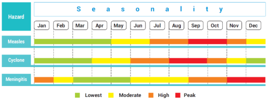
Defining the seasonality of each hazard involves identifying the months of the year during which the hazard is most likely to occur. Based on a consensus approach, the seasonality of the hazard is defined on a green, red colour scale, with ‘red’ indicating the point in time when the hazard is most likely to occur (
Figure 2).
Figure 2. STAR emergency and disaster risk calendar.
Once frequency and seasonality have been defined, the resulting outputs can be used to determine the likelihood of a hazard
. This step estimates the probability of the hazard occurring in the setting in the next 12 months at the scale from almost certain to very unlikely:
1) Almost certain: likely to occur in the next 12 months in most circumstances (Probability of 95% or more)
2) Very likely: likely to occur in the next 12 months in most circumstances (Probability of between 70% and 94%)
3) Likely: could occur in the next 12 months some of the time (Probability of between 30% and 69%)
4) Unlikely: could occur in the next 12 months some of the time (Probability of between 5% and 29%)
5) Very unlikely: could occur in the next 12 months under exceptional circumstances (Probability of less than 5%).
2.3. Estimating the Impact of the Risk to the Country
The third step in a strategic risk assessment using the STAR methodology is to calculate the impact of each hazard.
Severity, vulnerability, and coping capacity are assessed separately, and the results then used to calculate an estimated impact of the hazard.
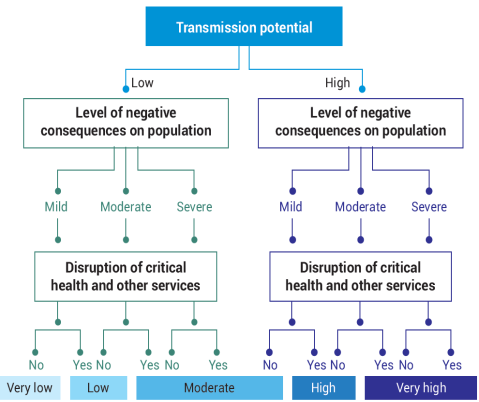
When conducting the severity assessment for biological hazards, the following information is required:
1) Transmission potential (mode of transmission or basic reproduction number [R0])
2) Level of negative consequences on population (morbidity, forced displacement of a population and mortality, population movement restrictions)
3) Disruption to essential health and other services (mortality and morbidity, risk of outbreaks, immunization service, malnutrition, psychological health)
4) Effect on health workforce.
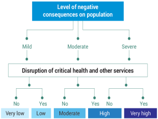
5) When conducting the severity assessment for geological, hydrometeorological, technological and societal hazards, the following information is required:
6) Level of negative consequences on population (morbidity, forced displacement of a population and mortality, mental stress, population movement restriction)
7) Disruption to essential health and other services
8) Effect on health workforce
Severity assessment is based on the two assessment algorithms shown in
Figure 3 (biological hazards) and
Figure 4 (geological, hydrometeorological, societal and technological hazards) below.
Figure 3. Algorithm for assessment of the level of severity (Biological hazards).
Figure 4. Algorithm for assessment of the level of severity (Geological, hydrometeorological, societal and technological hazards).
Vulnerability refers to the characteristics and circumstances of an individual, community, system or asset that make it susceptible to the damaging effects of a hazard. When assessing vulnerability as it relates to a particular hazard, the following factors should be considered in relation to the population:
1) Health status of the populations at risk (gender, age, chronic conditions, malnourishment, immunity, …)
2) Social determinants of health (literacy, unemployment, access to housing, income status)
3) Presence of vulnerable groups (migrants, homeless, displaced populations, older adults,...)
4) Environmental factors (unsafe drinking-water, sanitation and waste management, food insecurity, environment pollution, proximity of mosquito vector breeding sites of industrial establishments, overcrowding, community and political unrest, …).
The level of vulnerability by category are defined as below:
1) 5: Very high
2) 4: High
3) 3: Moderate
4) 2: Low
5) 1: Very low
Coping capacity measures how people, organizations, and systems use available skills and resources to manage adverse conditions, risks or disasters as related to the identified hazard
. the following coping capacity framework includes:
1) Governance: national policies, strategies, legislation, regulatory systems that integrate emergency, existing plans for emergency, multisectoral coordination mechanisms inclusive of health, research development and regulatory legislation that inform and accelerate emergency preparedness and response, inclusive of vaccine development, therapeutics and biomedical equipment, existing regulations and legislation related to new and unknown pathogens
| [12] | Centre for Research on the Epidemiology of Disasters. International Disaster Database. Brussels: EM-DAT; 2019.
https://www.emdat.be/ |
[12]
2) Health sector: existing surveillance and early warning systems, laboratory networks, information and knowledge management, functional capacity of health facilities, supply chain functionality, functionality of basic and safe health and emergency services, key human resources, inclusive of training and competency development and occupational health and safety for the health workforce, surge capacity
3) Non-health sector: existing surveillance and early warning systems for hydro-meteorological, societal and environmental hazards, functional capacity to capture and share non-health data, such as population movement, animal, surveillance data, flight and weather patterns, with the health sector, inclusive of training and competency development relevant to emergency, community capacities knowledge, attitude and practices of vulnerable populations about the hazard and prevention and control measures existing mechanisms for risk communications, community engagement and infodemic management
4) Resources: financial resources for emergency, mechanisms for logistics, storage and essential supplies for emergency deployment, other needed resources and multisectoral structures for supporting vulnerable populations during emergencies.
After discussing the current level of coping capacity for each hazard within the country, the level of coping capacity should be assessed for each identified hazard and ranked using the criteria below. For this step, the coping capacity is scaled in reverse order: the higher the country’s coping capacity is assessed, the lower the resulting score.
1) 1: Very high (All coping capacities required for the specific hazard are functional and sustainable, and the country is supporting one or more other countries in their implementation
2) 2: High (All coping capacities required for the hazard are available but have never been stressed under real conditions or tested during simulation exercise
3) 3 Moderate (Some coping capacities required for the hazard are available, but functionality and sustainability have not been ensured, such as through inclusion in the operational plan of the national health sector plan with a secure funding source
4) 4: Low (Core coping capacities required for the hazard are in the developmental stage. Implementation has started with some attributes achieved and others commenced
5) 5: Very low Core coping capacities required for the hazard (human, material, strategic and financial) are mostly or completely not available.
The model will determine the impact automatically using the aggregation of the scores assigned for severity, vulnerability and coping capacity. The tool calculates the impact score automatically using the following formula:
impact score = (severity+vulnerability+coping capacity)/3
Based on the results of this calculation, STAR automatically assigns an impact score from 1 (negligible) to 5 (critical). The impact scoring criteria are highlighted below:
1) 1: Negligible
2) 2: Minor
3) 3: Moderate
4) 4: Severe
5) 5: Critical
2.4. Determining the Estimated Level of Risk
To determine the confidence level of the risk description, three levels of confidence based in the information available are most applicable per each hazard:
Good: high quality evidence, multiple reliable sources, verified, expert opinion concurs, experience of previous similar incidents
Satisfactory: adequate quality evidence, reliable source(s), assumptions made by analogy, agreement between experts
Unsatisfactory: little and poor-quality evidence, uncertainty and conflicting views exist between experts, no experience with previous similar incidents.
The model will determine the level of risk carried by each hazard automatically using the following scale:
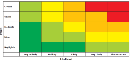
‘Very Low’, ‘Low’, ‘Moderate’, ‘High’, and ‘Very High’. The risk matrix will be automatically populated within the tool based on the inputs from the workshop discussions from differents Steps. The automatically generated risk matrix provides a visual and simple overview of the results of the strategic risk assessment. The risk matrix plots the impact and likelihood of risk on an illustrative graph, showing priority risks to inform preparedness and risk reduction activities
Figure 5).
Figure 5. Risk matrix model.
3. Results
3.1. Risk Assessment and Mapping in 2022
3.1.1. Identifying Country Hazard
In total, 23 health risks were prioritized out of the 96 identified. These risks were classified into five categories:
1) Biological hazards (13): COVID-19, pneumonic plague, poliomyelitis, measles, rabies, malaria, dengue, chikungunya, Rift Valley Fever (RVF), Foodborne Disease Outbreak (FBDO), Food poisoning from marine toxins, Severe Acute Respiratory Syndrome (SARS), Antimicrobial Resistance (AMR)
2) Hydrometeorological hazards (4): cyclones, floods, droughts, landslides
3) Technological hazards (2): chemical agents, industrial fires
4) Societal hazards (3): transportation accidents, social conflicts, insecurity
5) Environnemental hazard (1): ambient air pollution.
3.1.2. Risk Matrix
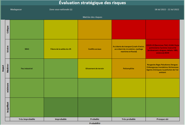
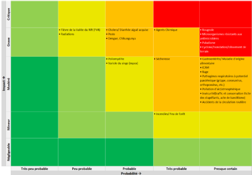
Risks were classified according to a matrix combining the probability of occurrence of hazards and their impact on health (
Figure 6):
Very high risks (7), in red: almost certain probability, severe impacts (COVID-19, FBDO, Food poisoning from marine toxins, pneumonic plague, cyclones, insecurity, AMR)
High risks (12), in orange
1) Social conflicts: probable probability, severe impacts
2) Transportation accidents: very likely probability, severe impacts
3) Poliomyelitis: very likely probability, moderate impacts
4) Measles, rabies, malaria, dengue, chikungunya, flooding, drought, chemical agents, ambient air pollution: almost certain probability, moderate impacts
Moderate risks (2), in yellow
1) RVF: unlikely probability, severe impacts
2) Landslides: probable probability, moderate impacts
Low risk (1), en green: very unlikely probability, severe impacts (SARS)
Very low risk (1), en green: very unlikely probability, moderate impacts (Industrial fires)
Figure 6. Madagascar Risk matrix, STAR 2022.
3.1.3. Risk Calendar
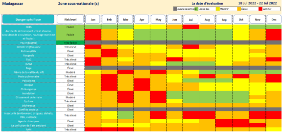
Figure 7. Madagascar Risk calendar, STAR 2022.
According to
Figure 7, all of the identified hazards exhibit seasonality throughout the year, with the exception of social conflicts, rabies, and industrial fires, which do not follow any apparent seasonal pattern. Among the seasonal hazards, pneumonic plague and insecurity stand out with recurring peaks in frequency throughout the year. Furthermore, drought is a persistent phenomenon, observed almost constantly throughout the year.
3.1.4. Risk Mapping
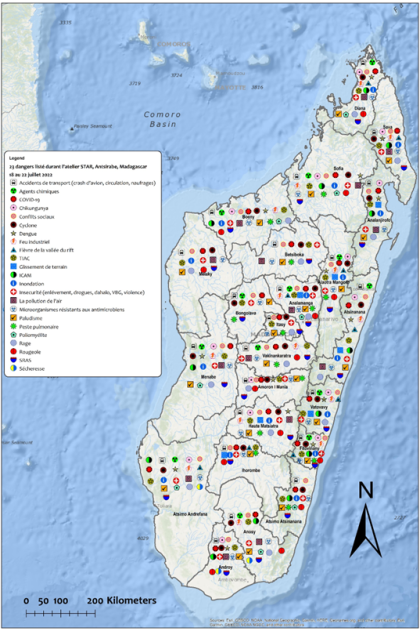
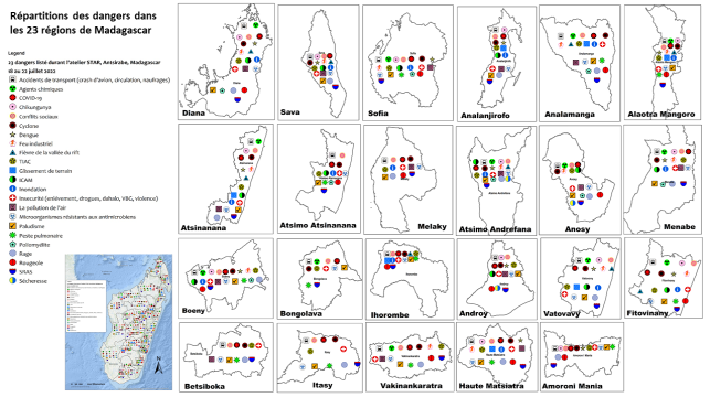
According to Figure below, 8/23 hazards were identified across Madagascar's 23 regions, including:
Very high-risk hazards (5/7): COVID-19, FBDO, cyclones, insecurity, AMR
High-risk hazards (2/12): social conflicts, malaria
Low-risk hazard (1/1): SARS.
However, some hazards were observed in a limited number of regions: poliomyelitis in 8 regions, landslides in 7 regions, drought in 3 regions.
Furthermore, 3 regions with the highest number of hazards are Diana (20/23), Boeny (20/23), and Analamanga (19/23). Conversely, the least exposed regions are Itasy and Bongolava with 11 hazards each, and Betsiboka with 12 hazards (
Figures 8, 9).
Figure 8. Madagascar global risk mapping, STAR 2022.
Figure 9. Madagascar regional risk mapping, STAR 2022.
3.2. Risk Assessment and Mapping in 2025
3.2.1. Identifying/Updating Country Hazard
A total of 21 health hazards were listed out of the 30 listed, based on STAR 2022, as follows:
Removing, grouping, renaming hazard
2 hazards removed (COVID-19, SARS), grouped and renamed under “Flu”
3 hazards (cyclones, floods, landslides) grouped into a single “cyclones/floods/landslide”
2 hazards (dengue/chikungunya) grouped into a single “dengue/chikungunya”
1 hazard removed (Industrial fires) and renamed as “Fire”
1 hazard removed (Social conflict) and changed on “insecurity”
Reduction in the number of hazards by category
Decrease of the number of hydrometeorological et technological hazards
Increase of the number of environmental hazards
Changing level of risk
Increase of risk level (3): measles, malaria, landslide
Decrease of risk level (4): pneumonic plague, poliomyelitis, FBDO, Food poisoning from marine toxins
Absence of low or very low risk
Adding new hazards: cholera, mpox, ionizing radiation
List of hazards:
1) Biological hazards (13): flu, pneumonic plague, poliomyelitis, measles, rabies, malaria, dengue/chikungunya, RVF, FBDO, Food poisoning from marine toxins, AMR, cholera, mpox
2) Hydrometeorological hazards (2): cyclones/ floods/landslides, droughts
3) Technological hazards (2): chemical agents, ionizing iradiation
4) Societal hazards (2): transportation accidents, insecurity
5) Environnemental hazard (2): ambient air pollution, fires.
3.2.2. Risk Matrix
According to figure 8, there are 3 categories of risk in 2025 (
Figure 10):
Very high risks (4), in red: almost certain probability, severe impacts (Cyclones/floods/landslides, malaria, measles, AMR)
High risks (12), in orange
1) Pneumonic plague, dengue/chikungunya, cholera: probable probability, severe impacts
2) Drought: very likely probability, moderate impacts
3) Chemical agents: very likely probability, severe impacts
4) transportation accidents, FBDO, food poisoning from marine toxins, insecurity, flu, rabies, ambient air pollution: almost certain probability, moderate impacts
Moderate risks (5), in yellow
1) RVF, ionizing radiation: unlikely probability, severe impacts
2) Poliomyelitis, mpox: probable probability, moderate impacts
3) Fire: very likely probability, minor impact
Figure 10. Madagascar Risk matrix, STAR 2025.
3.2.3. Risk Calendar
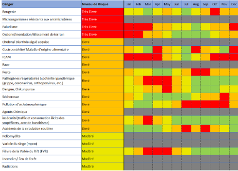
According to figure 11, all of the identified hazards exhibit seasonality throughout the year, with the exception of 8 hazard (AMR, rabies, chemical agent, fire, ionizing radiation, poliomyelitis, cholera, mpox). The first quarter represents the period with the highest peak observed (
Figure 11).
Figure 11. Madagascar Risk calendar, STAR 2025.
3.2.4. Risk Mapping
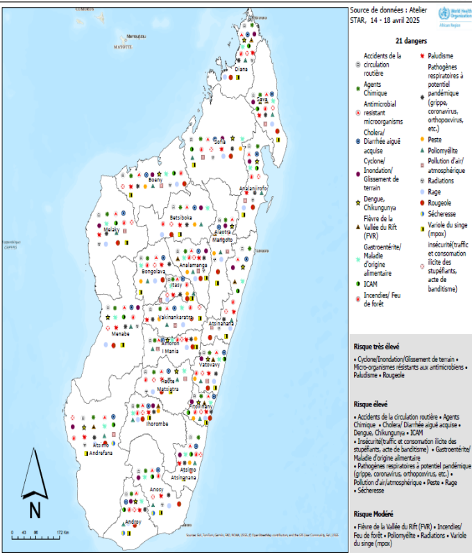
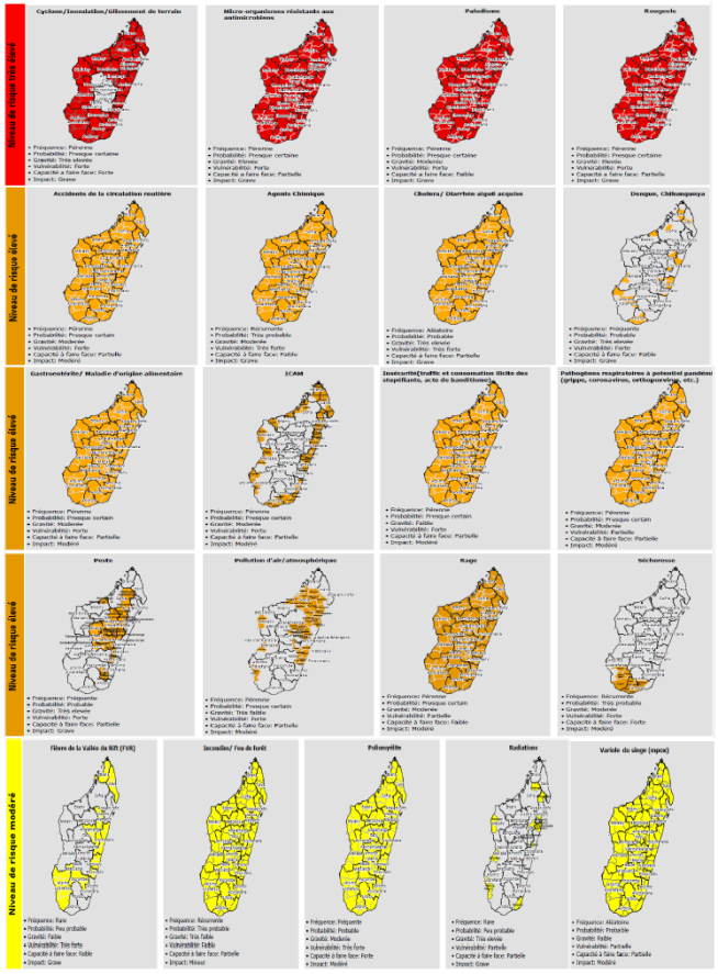
According to Figure below, 13/21 hazards were identified across Madagascar's 23 regions, including:
1) Very high-risk hazards (3/4): AMR, malaria, measles
2) High-risk hazards (7/12): cholera, chemical agents, transportation accidents, FBDO, insecurity, flu, rabies,
3) Moderate-risk hazard (3/5): poliomyelitis, mpox, fire (
Figures 12, 13).
Figure 12. Madagascar global risk mapping, STAR 2025.
Figure 13. Madagascar regional risk mapping, STAR 2025.
4. Discussion
The strategic assessment of health risks in Madagascar, carried out using the STAR tool, identified 23 priority hazards among 96 listed and 21 priority hazards among 30 listed respectively in 2022 and 2025.
As a qualitative assessment, the STAR tool is not governed by statistical representativeness, mathematical modeling, or a substitute for detailed sectoral assessments, such as Joint Risk Assessment Tool, Vulnerability and Risk Analysis and Mapping (VRAM) Platform for Health Risk Reduction, and others
| [13] | World Health Organization, Food and Agriculture Organization of the United Nations, World Organization for Animal Health. Joint Risk Assessment Operational Tool (JRA OT). An Operational Tool of the Tripartite Zoonoses Guide Taking a Multisectoral, One Health Approach: A Tripartite Guide to Addressing Zoonotic Diseases in Countries. WHO, FAO, OIE; 2020. |
| [14] | Ethiopian Public Health Institute. Guideline for Conducting Vulnerability Risk Assessment Mapping & Emergency Preparedness and Response Planning for Public Health Emergencies. EPHI; 2022. |
[13, 14]
. However, it can quickly generate results in resource-constrained settings and provide an efficient basis for planning
| [1] | World Health Organization. Strategic toolkit for assessing risks: a comprehensive toolkit for all-hazards health emergency risk assessment. Geneva: WHO; 2021. Licence: CC BY-NC-SA 3.0 IGO. |
[1]
.
According to WHO guidelines, the country should apply STAR every 2-3 years to update their risk profile, develop action points and recommendations to prevent, respond to and recover from risks and monitor the implementation of recommendations from previous STAR exercise, alongside their integration into the national or subnational action planning process
| [1] | World Health Organization. Strategic toolkit for assessing risks: a comprehensive toolkit for all-hazards health emergency risk assessment. Geneva: WHO; 2021. Licence: CC BY-NC-SA 3.0 IGO. |
[1]
.
Specifically, Madagascar has reviewed and updated STAR results due the following circumstances:
1) The change of COVID-19 epidemiological situation
| [15] | World Health Organization. From emergency response to long-term COVID-19 disease management: sustaining gains made during the COVID-19 pandemic. Geneva: WHO; 2023 (WHO/WHE/SPP/2023.1). Licence: CC BY-NC-SA 3.0 IGO. |
| [16] | World Health Organization. Ending the COVID-19 emergency and transitioning from the emergency phase to longer-term disease management: Guidance on calibrating the response. Geneva: WHO; 2023 (WHO/WHE/SPP/2023.2). License: CC BY-NC-SA 3.0 IGO. |
[15, 16]
2) Given significant changes in any of the parameters used in the STAR methodology (likelihood, severity, vulnerability, coping capacity): particularly after COVID-19 pandemic and other biological hazards such as pneumonic plague and poliomyelitis
| [17] | Ministère de la Santé publique. Revue Intra-Action de la COVID-19 à Madagascar. Rapport technique. Madagascar: MSANP; 2021. |
| [18] | Ministère de la Santé publique. Weekly S10. Madagascar: MSANP; 2025. |
[17, 18]
3) Climate change
| [19] | World Health Organization. Health at the heart of national adaptation planning: a global review of national adaptation plans and health national adaptation plans. Geneva: WHO; 2025. Licence: CC BY-NC SA 3.0 IGO. |
[19]
4) Emergency response like cholera at neighboring countries and mpox as Public Health Emergency of International Concern
5) Mining project in the southern part of the country
These situations justify the removing, grouping, level changing, adding new hazards based on the context and settings in the country.
According to Madagascar risk profile, it confirms the diversity and complexity of the health threats to which the country is exposed. This approach, based on a participatory and multisectoral methodology, is in line with WHO recommendations aimed at strengthening the resilience of health systems in the face of health emergencies
| [1] | World Health Organization. Strategic toolkit for assessing risks: a comprehensive toolkit for all-hazards health emergency risk assessment. Geneva: WHO; 2021. Licence: CC BY-NC-SA 3.0 IGO. |
[1]
.
The global results highlighted that very high risks included biological hazards and climate hazards such as cyclones/floods/landslides. This classification was consistent with trends observed in other African countries, where combined biological and climatic risks dominated vulnerability profiles. However, a notable difference lies in the predominance of hemorrhagic infectious diseases such as Ebola virus disease and Crimean-Congo hemorrhagic fever, which are more common in certain regions of West and Central Africa
| [23] | Organisation Mondiale de la Santé. Évaluation et Cartographie des risques sanitaires avec l’outil STAR en République Démocratique du Congo, Mali, Sénégal, Guinée, Burundi et République Centrafricaine. Rapport technique de mission. OMS; 2024. |
[23]
.
Risk mapping revealed a concentration of threats in densely populated urban areas, particularly in the Analamanga, Boeny, and Diana regions, highlighting the need for a territorialized approach to risk management. This finding is consistent with the conclusions of similar assessments conducted in the Democratic Republic of Congo, Mali, Senegal, Guinea, Burundi, and the Central African Republic, where urban areas appear to be more exposed and vulnerable due to population density and pressure on health infrastructure
| [23] | Organisation Mondiale de la Santé. Évaluation et Cartographie des risques sanitaires avec l’outil STAR en République Démocratique du Congo, Mali, Sénégal, Guinée, Burundi et République Centrafricaine. Rapport technique de mission. OMS; 2024. |
| [24] | World Health Organization. Taking a strategic approach to urban health: a guide for decision-makers. Executive summary. Geneva: WHO; 2025. https://doi.org/10.2471/B09620 Licence: CC BY-NC-SA 3.0 IGO. |
[23, 24]
.
The STAR tool also highlighted the seasonality of certain risks, such as infectious disease and meteorological hazards. Seasonality is an inherent feature of ecological systems. It is a ubiquitous feature of acute infectious diseases and differs from other diseases within the same location. Seasonal variation in infectious disease transmission plays an important role in determining when epidemics happen. Environmental factors, specifically climate conditions, are the seasonal drivers that have received the most attention for measles, poliomyelitis, flu, and cholera. This temporality is a key factor in planning interventions and allocating resources effectively
| [25] | Martinez ME. The calendar of epidemics: Seasonal cycles of infectious diseases. PLoS Pathog; 2018: 14(11): e1007327.
https://doi.org/10.1371/journal.ppat.1007327 |
| [26] | Mantilla-Beniers NB, Bjørnstad ON, Grenfell BT, Rohani P. Decreasing Stochasticity Through Enhanced Seasonality in Measles Epidemics. Journal of the Royal Society, Interface / the Royal Society. 2010; 7(46): 727–39.
https://doi.org/10.1098/rsif.2009.0317 |
| [27] | Martinez-Bakker M, King AA, Rohani P. Unraveling the Transmission Ecology of Polio. PLoS Biol. 2015; 13(6): e1002172 https://doi.org/10.1371/journal.pbio.1002172 |
| [28] | Shaman J, Pitzer VE, Viboud C, Grenfell BT, Lipsitch M. Absolute Humidity and the Seasonal Onset of Influenza in the Continental United States. PLoS Biol. 2010; 8(2): e1000316 https://doi.org/10.1371/journal.pbio.1000316 |
| [29] | Bouma MJ, Pascual M. Seasonal and Interannual Cycles of Endemic Cholera in Bengal 1891–1940 in Relation to Climate and Geography. Hydrobiologia. 2001; 460: 147–156.
https://doi.org/10.1023/A:1013165215074 |
[25-29]
.
Finally, the STAR approach promotes transparency and stakeholder ownership of results, which is essential for the implementation of recommendations. These are represented by the development and/or updating of contingency plans for all hazard classified as very high and all hazard classified as high as well as a Mult hazard plan for all identified risks and the NAPHS. These plans will be tested through simulation exercises, then implemented, monitored, and evaluated in order to prevent, prepare for, detect, respond to, and recover from emergencies related to these priority risks. The involvement of multisectoral actors strengthens the legitimacy of decisions and facilitates the integration of results into public policy
| [1] | World Health Organization. Strategic toolkit for assessing risks: a comprehensive toolkit for all-hazards health emergency risk assessment. Geneva: WHO; 2021. Licence: CC BY-NC-SA 3.0 IGO. |
[1]
.
6. Conclusions
Emergencies are becoming more frequent and more severe, and no country, regardless of its level of economic and social development, is spared. All countries need clear policies, strategies, and related programs to limit the health risks and health and other consequences of these situations. These policies and strategies must be multidisciplinary and intersectoral, adopting comprehensive approaches that take into account all hazards and are based on risk management.
While managing risks related to emergencies and disasters in the health context requires multifaceted strategies and specific measures to address the multiple risks associated with emergencies, it is nonetheless essential to strengthen countries' health systems overall, with a focus on primary health care.
The strategic assessment of health risks in Madagascar, carried out using the WHO's STAR tool, identified priority risks affecting public health, including biological, climatic, and societal risks. Therefore, as part of the preparation for responding to emergencies related to these various risks, it is important to develop control strategies. This approach has been supplemented by strategies. to combat priority diseases. At the same time, WHO recommends the development/update of national contingency plan for very high and high risk, and a multihazard plan for all identified hazards, following an exercise simulation.
The integration of these three components provides a holistic view of health risk management in Madagascar. The preliminary assessment of the health risk profile in Madagascar provided an evidence base for prioritizing interventions and rationalizing the allocation of resources for priority risks.
Abbreviations
AMR | Anti-microbial Resistance |
FBDO | Foodborne Disease Out-break |
IHR | International Health Regulation |
NAPHS | National Action Plan for Health Security |
RVF | Rift Valley Fever |
SARS | Severe Acute Respiratory Syndrome |
STAR | Strategic Tool for Assessing Risk |
WHO | World Health Organization |
Acknowledgments
The authors acknowledge Ministry of public health, Mul-tisectorial stakeholders in “One health plateform”, WHO.
Author Contributions
Vatsiharizandry Mandrosovololona: Conceptualization, Formal analysis, Investigation, Methodology, Writing – original draft, Writing – review & editing
Daniel Yota: Formal analysis, Investigation, Methodology
Christian Massidi: Data curation, Formal analysis, Software
Harinirina Raseheno: Investigation, Visualization
Lethicia Lydia Yasmine: Project administration
Laurent Musango: Supervision, Validation
Funding
This work is supported by World Bank and WHO
Data Availability Statement
The data supporting the outcome of this research work has been reported in this manuscript.
Conflicts of Interest
The authors declare no conflicts of interest.
References
| [1] |
World Health Organization. Strategic toolkit for assessing risks: a comprehensive toolkit for all-hazards health emergency risk assessment. Geneva: WHO; 2021. Licence: CC BY-NC-SA 3.0 IGO.
|
| [2] |
Bureau National de Gestion des Risques et des Catastrophes. Plan de contingence multi-risques du gouvernement et du comité permanent inter-agences 2015-2016. Madagascar: BNGRC; 2015.
|
| [3] |
Ministère de la Santé publique. Plan de Développement du Secteur Santé 2020-2024. Madagascar: MSANP; 2020.
|
| [4] |
World Health Organization. Glossary of Health Emergency and Disaster Risk Management Terminology. Geneva: WHO; 2020. Licence: CC BY-NC-SA 3.0 IGO.
|
| [5] |
Nations Unies. Cadre d'action de Sendai pour la réduction des risques de catastrophe 2015-2030.
|
| [6] |
Organisation Mondiale de la Santé. Un PANSS pour tous: Cadre stratégique en trois étapes relatives au Plan d’action national pour la sécurité sanitaire (PANSS). Genève: OMS; 2019 (WHO/WHE/CPI/2018.52). Licence: CC BY NC SA 3.0 IGO.
|
| [7] |
Organisation mondiale de la Santé. Évaluation externe conjointe des principales capacités RSI de la République de Madagascar. Genève: OMS; 2017 (WHO/WHE/CPI/REP/2017.66). License: CC BY-NC-SA 3.0 IGO.
|
| [8] |
Organisation Mondiale de la Santé. Cadre de gestion des risques liés aux situations d’urgence et aux catastrophes dans le contexte de la santé. Genève: OMS; 2021. Licence: CC BY-NC-SA 3.0 IGO.
|
| [9] |
Jackson LE. Frequency and magnitude of events. In: Bobrowsky PT, editor. Encyclopedia of natural hazards. Encyclopaedia of earth sciences series. Dordrecht: Springer; 2013.
|
| [10] |
World Meteorological Organization. International cloud atlas. Geneva: 2018.
https://cloudatlas.wmo.int/haze.html
|
| [11] |
United Nations. Recommendations for the transport of dangerous goods, 19th edition. New York and Geneva: United Nations; 2015.
https://www.unece.org/fileadmin/DAM/trans/danger/publi/unrec/rev19/Rev19e_Vol_I.pdf
|
| [12] |
Centre for Research on the Epidemiology of Disasters. International Disaster Database. Brussels: EM-DAT; 2019.
https://www.emdat.be/
|
| [13] |
World Health Organization, Food and Agriculture Organization of the United Nations, World Organization for Animal Health. Joint Risk Assessment Operational Tool (JRA OT). An Operational Tool of the Tripartite Zoonoses Guide Taking a Multisectoral, One Health Approach: A Tripartite Guide to Addressing Zoonotic Diseases in Countries. WHO, FAO, OIE; 2020.
|
| [14] |
Ethiopian Public Health Institute. Guideline for Conducting Vulnerability Risk Assessment Mapping & Emergency Preparedness and Response Planning for Public Health Emergencies. EPHI; 2022.
|
| [15] |
World Health Organization. From emergency response to long-term COVID-19 disease management: sustaining gains made during the COVID-19 pandemic. Geneva: WHO; 2023 (WHO/WHE/SPP/2023.1). Licence: CC BY-NC-SA 3.0 IGO.
|
| [16] |
World Health Organization. Ending the COVID-19 emergency and transitioning from the emergency phase to longer-term disease management: Guidance on calibrating the response. Geneva: WHO; 2023 (WHO/WHE/SPP/2023.2). License: CC BY-NC-SA 3.0 IGO.
|
| [17] |
Ministère de la Santé publique. Revue Intra-Action de la COVID-19 à Madagascar. Rapport technique. Madagascar: MSANP; 2021.
|
| [18] |
Ministère de la Santé publique. Weekly S10. Madagascar: MSANP; 2025.
|
| [19] |
World Health Organization. Health at the heart of national adaptation planning: a global review of national adaptation plans and health national adaptation plans. Geneva: WHO; 2025. Licence: CC BY-NC SA 3.0 IGO.
|
| [20] |
World Health Organization. Weekly epidemiological record. Geneva: WHO; 2025: 36(100): 347–364.
http://www.who.int/wer
|
| [21] |
World Health Organization. WHO’s response to the global mpox outbreak. Geneva: WHO; 2025.
https://www.who.int/emergencies/en
|
| [22] |
Base Resources. Toliara Monazite Project Pre-Feasibility Study. 2023.
https://baseresources.com.au/investors/announcements/
|
| [23] |
Organisation Mondiale de la Santé. Évaluation et Cartographie des risques sanitaires avec l’outil STAR en République Démocratique du Congo, Mali, Sénégal, Guinée, Burundi et République Centrafricaine. Rapport technique de mission. OMS; 2024.
|
| [24] |
World Health Organization. Taking a strategic approach to urban health: a guide for decision-makers. Executive summary. Geneva: WHO; 2025.
https://doi.org/10.2471/B09620
Licence: CC BY-NC-SA 3.0 IGO.
|
| [25] |
Martinez ME. The calendar of epidemics: Seasonal cycles of infectious diseases. PLoS Pathog; 2018: 14(11): e1007327.
https://doi.org/10.1371/journal.ppat.1007327
|
| [26] |
Mantilla-Beniers NB, Bjørnstad ON, Grenfell BT, Rohani P. Decreasing Stochasticity Through Enhanced Seasonality in Measles Epidemics. Journal of the Royal Society, Interface / the Royal Society. 2010; 7(46): 727–39.
https://doi.org/10.1098/rsif.2009.0317
|
| [27] |
Martinez-Bakker M, King AA, Rohani P. Unraveling the Transmission Ecology of Polio. PLoS Biol. 2015; 13(6): e1002172
https://doi.org/10.1371/journal.pbio.1002172
|
| [28] |
Shaman J, Pitzer VE, Viboud C, Grenfell BT, Lipsitch M. Absolute Humidity and the Seasonal Onset of Influenza in the Continental United States. PLoS Biol. 2010; 8(2): e1000316
https://doi.org/10.1371/journal.pbio.1000316
|
| [29] |
Bouma MJ, Pascual M. Seasonal and Interannual Cycles of Endemic Cholera in Bengal 1891–1940 in Relation to Climate and Geography. Hydrobiologia. 2001; 460: 147–156.
https://doi.org/10.1023/A:1013165215074
|
Cite This Article
-
APA Style
Mandrosovololona, V., Yota, D., Massidi, C., Raseheno, H., Yasmine, L. L., et al. (2026). National Health Risk Assessment and Mapping Using the WHO Strategic Tool for Assessing a Risk (STAR), in Madagascar from 2022 to 2025. American Journal of Health Research, 14(4), 204-218. https://doi.org/10.11648/j.ajhr.20261404.14
 Copy
|
Copy
|
 Download
ACS Style
Mandrosovololona, V.; Yota, D.; Massidi, C.; Raseheno, H.; Yasmine, L. L., et al. National Health Risk Assessment and Mapping Using the WHO Strategic Tool for Assessing a Risk (STAR), in Madagascar from 2022 to 2025. Am. J. Health Res. 2026, 14(4), 204-218. doi: 10.11648/j.ajhr.20261404.14
Copy
|
Download
AMA Style
Mandrosovololona V, Yota D, Massidi C, Raseheno H, Yasmine LL, et al. National Health Risk Assessment and Mapping Using the WHO Strategic Tool for Assessing a Risk (STAR), in Madagascar from 2022 to 2025. Am J Health Res. 2026;14(4):204-218. doi: 10.11648/j.ajhr.20261404.14
Copy
|
Download
-
@article{10.11648/j.ajhr.20261404.14,
  author = {Vatsiharizandry Mandrosovololona and Daniel Yota and Christian Massidi and Harinirina Raseheno and Lethicia Lydia Yasmine and Laurent Musango},
  title = {National Health Risk Assessment and Mapping Using the WHO Strategic Tool for Assessing a Risk (STAR), in Madagascar from 2022 to 2025},
  journal = {American Journal of Health Research},
  volume = {14},
  number = {4},
  pages = {204-218},
  doi = {10.11648/j.ajhr.20261404.14},
  url = {https://doi.org/10.11648/j.ajhr.20261404.14},
  eprint = {https://article.sciencepublishinggroup.com/pdf/10.11648.j.ajhr.20261404.14},
  abstract = {Madagascar regularly faces disasters and health emergencies. It is one of the countries vulnerable to various disaster risks and climate change. Since 2014, the country has been affected by large-scale epidemics and natural disasters. In order to strengthen prevention, preparedness, response, and resilience to health threats, the World Health Organization (WHO) recommends that countries conduct a health risk assessment and mapping as the first step in the emergency management cycle in the context of limited resources and update the risk profile every three years. The objectives are to identify and characterize the various priority health risks in Madagascar, assess the probability of their occurrence, estimate their potential impact, determine the estimated level of risk, categorize them, and map them in order to formulate key recommendations. This is a qualitative, multisectoral, and multi-hazard assessment, combined with national health risk mapping using the WHO's Strategic Tool for Assessing Risk (STAR). The first assessment was conducted in 2022, followed by an update of the health risk profile in 2025. The results obtained in 2022 identified 23 health threats out of the 96 identified. In 2025, during the update, 21 threats were retained, including 3 threats that were removed.},
 year = {2026}
}
Copy
|
Download
-
TY  - JOUR
T1  - National Health Risk Assessment and Mapping Using the WHO Strategic Tool for Assessing a Risk (STAR), in Madagascar from 2022 to 2025
AU  - Vatsiharizandry Mandrosovololona
AU  - Daniel Yota
AU  - Christian Massidi
AU  - Harinirina Raseheno
AU  - Lethicia Lydia Yasmine
AU  - Laurent Musango
Y1  - 2026/07/27
PY  - 2026
N1  - https://doi.org/10.11648/j.ajhr.20261404.14
DO  - 10.11648/j.ajhr.20261404.14
T2  - American Journal of Health Research
JF  - American Journal of Health Research
JO  - American Journal of Health Research
SP  - 204
EP  - 218
PB  - Science Publishing Group
SN  - 2330-8796
UR  - https://doi.org/10.11648/j.ajhr.20261404.14
AB  - Madagascar regularly faces disasters and health emergencies. It is one of the countries vulnerable to various disaster risks and climate change. Since 2014, the country has been affected by large-scale epidemics and natural disasters. In order to strengthen prevention, preparedness, response, and resilience to health threats, the World Health Organization (WHO) recommends that countries conduct a health risk assessment and mapping as the first step in the emergency management cycle in the context of limited resources and update the risk profile every three years. The objectives are to identify and characterize the various priority health risks in Madagascar, assess the probability of their occurrence, estimate their potential impact, determine the estimated level of risk, categorize them, and map them in order to formulate key recommendations. This is a qualitative, multisectoral, and multi-hazard assessment, combined with national health risk mapping using the WHO's Strategic Tool for Assessing Risk (STAR). The first assessment was conducted in 2022, followed by an update of the health risk profile in 2025. The results obtained in 2022 identified 23 health threats out of the 96 identified. In 2025, during the update, 21 threats were retained, including 3 threats that were removed.
VL  - 14
IS  - 4
ER  -
Copy
|
Download

 ,
Daniel Yota
,
Daniel Yota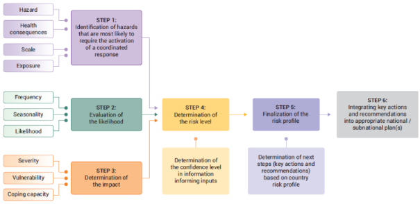



 Share This Article
 Twitter
 Linked In
 Facebook