This paper discusses the development of the Geospatial Building Information Infrastructure (GBII) for the developing Federal Polytechnic in Ilaro, Nigeria. It demonstrates how participants in interdisciplinary building projects, such as surveyors, engineers, and architects, can collaborate effectively using the same digital model. Model visualization and design coordination improve when data from multiple sources are merged into a single model. This allows for more informed decisions about costs and resource allocation. To obtain high-quality geospatial data, Global Navigation Satellite System (GNSS) surveying techniques were combined with Unmanned Aerial Vehicle (UAV) data captured. Field surveys were first carried out to maximize the effectiveness of the flight procedure and establish the best placement of GCPs. Preliminary satellite imagery analysis helped design UAV flight paths and select the potential GCP location in the study area. Before data collection, the instrument's test was done to ensure its good working condition. Spatial datasets were collected using a Tarsus Oscar GNSS device for the GCPs and a DJI Phantom 4 Pro V2 UAV for the aerial photos. Digital surface model (DSM) and Digital terrain model (DTM) maps were derived from the image processed using the software. The output maps reveal images of surfaces and the topography. All acquired datasets were visualized using the ArcGIS 10.6 system for mapping and analysis. The incorporation of UAV data in GBII improved data accuracy and visualization, and it has proven to be an efficient method.
This is an Open Access article, distributed under the terms of the Creative Commons Attribution 4.0 International License (http://creativecommons.org/licenses/by/4.0/), which permits unrestricted use, distribution and reproduction in any medium or format, provided the original work is properly cited.
Geospatial Building Information Infrastructure (GBII), Unmanned Aerial Vehicles (UAVs),
Geographic Information Systems (GIS)
1. Introduction
The rapid advancement of digital technology geared towards increasing efficiency, accuracy, and effective data management has led to a paradigm shift within the construction and infrastructure sectors
[1]
Y. A. Ahmed, H. M. F. Shehzad, M. M. Khurshid, O. H. Abbas Hassan, S. A. Abdalla, and N. Alrefai, “Examining the effect of interoperability factors on building information modelling (BIM) adoption in Malaysia,” Construction Innovation, vol. 24, no. 2, pp. 606–642, 2024.
. This technological evolution has led to the adoption of innovative tools and methodologies that enhance planning, design, construction, and facility management processes
[10]
J. O. Ndubuisi, G. Adene, T. B. Sunday, and E. C. Mbonu, “Development and implementation of Building Site Information Management,” World Journal of Advanced Research and Reviews, vol. 21, no. 2, pp. 1127–1135, 2024.
. Among these emerging technologies, Unmanned Aerial Vehicles (UAVs) and Geospatial Building Information Infrastructure (GBII) have gained considerable recognition as effective tools for infrastructure development and management. The demand for technology-driven integration is increasingly relevant owing to the limitations of conventional construction practices, which often result in poor site management and various construction-related problems
[17]
J. Zhu and P. Wu, “BIM/GIS data integration from the perspective of information flow,” Automation in Construction, vol. 136, 2022.
UAV-based imagery processing technology has proven to be a very successful technology for creating three-dimensional models of artificial objects and generating high-resolution orthophotography
[13]
M. J. Sobouti, A. Mohajerzadeh, H. Y. Adarbah, Z. Rahimi, and H. Ahmadi, “Utilizing UAVs in wireless networks: Advantages, challenges, objectives, and solution methods,” Vehicles, vol. 6, no. 4, pp. 1769–1800, 2024.
. Geospatial building information infrastructure has shown its potential to outperform the regular ground-based surveys in terms of efficiency, simplicity, and more advanced possibilities of constant surveillance. Moreover, geospatial building information infrastructure creates a detailed digital representation of building functions and materials
[15]
A. Waqar, I. Othman, N. Saad, M. Azab, and A. M. Khan, “BIM in green building: Enhancing sustainability in small construction projects,” Cleaner Environmental Systems, vol. 11, no. 3, pp. 329–346, 2023.
. Geospatial building information infrastructure acts as a common repository of information to make informed decisions throughout the whole life cycle of the asset, starting from its design and finishing with decommissioning
[4]
M. Aljarman, H. Boussabaine, and K. Almarri, “Emerging technical risks from the application of building information modelling,” Journal of Facilities Management, vol. 18, no. 3, pp. 195–212, 2020.
. It ensures the combination of multiple datasets into a single model and encourages communication among parties involved in facility management, planning, design, and construction processes. However, despite its capabilities, ongoing research continues to explore innovative approaches for enhancing GBII through the integration of complementary geospatial technologies and advanced data acquisition methods.
[7]
J. Kan, “The application of building information modeling in large scale railway integrated transportation hubs,” Theoretical and Natural Science, 2025.
[7]
.
Geographic Information Systems (GIS) Integration with GBII has recently received a lot of attention for its potential to improve spatial analysis and decision-making processes. Geospatial intelligence improves GBII by enabling infrastructure monitoring and environmental assessments
[17]
J. Zhu and P. Wu, “BIM/GIS data integration from the perspective of information flow,” Automation in Construction, vol. 136, 2022.
. Evidence indicates that GBII and GIS integration can be highly effective using tools such as the Feature Manipulation Engine (FME)
[16]
W. Wan Abdul Basir, U. Ujang, and Z. Bin Majid, “Building information modeling (BIM) and geographic information system (GIS) data compatibility for construction projects,” Journal of Information System and Technology Management, vol. 6, no. 24, pp. 278–289, 2021.
. The use of these technologies allows for easy data translation and workflow automation; the architecture created facilitates a deeper understanding of the environment and ensures dataset compatibility.
Advancements in geospatial data acquisition technologies have further strengthened the capabilities of these digital platforms. The Global Navigation Satellite System (GNSS), which encompasses GPS, GLONASS, BeiDou, and Galileo, provides highly accurate location, navigation, and timing services
[6]
International Air Transport Association (IATA), “Global Navigation Satellite System (GNSS),” USA, 2024.
[6]
. At the same time, unmanned aerial vehicles (UAVs) have become increasingly useful in collecting high-definition information used in carrying out aerial surveys. They are now considered essential instruments in geospatial research and construction due to their adaptability, affordability, rapid deployment capabilities, and ability to collect near-real-time data
[8]
K. Karbasishargh, M. M. Esfandabadi, and A. Esmaeili, “Innovative approaches to UAV performance: Enhancing safety, reliability, and flexibility,” International Journal of Reliability, Risk and Safety, 2024.
[8]
.
Despite these developments, infrastructure management remains constrained by traditional methods in many developing contexts. Federal Polytechnic Ilaro, Ogun State, Nigeria, is a typical example of how Geospatial Building Information infrastructure is limited by inconsistent data systems, manual and error-prone data collection methods, and the lack of real-time information frameworks; these limitations lead to out-of-date and inaccurate spatial datasets, impede integrated spatial analysis, and ultimately lower the efficiency of planning, maintenance, and decision-making processes
[5]
S. Ecke, F. Stehr, J. Frey, D. Tiede, J. Dempewolf, H.-J. Klemmt, E. Endres, and T. Seifert, “Towards operational UAV-based forest health monitoring: Species identification and crown condition assessment by means of deep learning,” Computers and Electronics in Agriculture, vol. 219, 2024.
B. Saad Alotaibi, A. Waqar, D. Radu, A. M. Khan, Y. Dodo, F. Althoey, and H. Almujibah, “Building information modeling (BIM) adoption for enhanced legal and contractual management in construction projects,” Ain Shams Engineering Journal, vol. 15, no. 7, 2024.
Furthermore, existing research has demonstrated the value of combining GBII and GIS technology with the use of unmanned aerial vehicles (UAVs) for infrastructure monitoring
[14]
M. Tkác and P. Mésároš, “Utilizing drone technology in civil engineering,” Selected Scientific Papers – Journal of Civil Engineering, vol. 14, pp. 27–37, 2019.
. However, there are still minimal studies that have examined the concept of establishing a drone-based infrastructure system for educational facilities in the context of developing nations, particularly Nigeria
[12]
V. F. Saraiva Landim, J. Poças Martins, and D. Calvetti, “From BIM to UAVs: A systematic review of digital solutions for productivity challenges in construction,” Applied Sciences, vol. 15, no. 19, 2025.
. It is challenging to efficiently monitor and plan for infrastructures since many institutions still depend on disconnected spatial records, analogue maps, and conventional documentation systems for their facilities.
To address these challenges, this study seeks to develop an integrated Geospatial Building Information Infrastructure for the West Campus of Federal Polytechnic Ilaro through the application of UAV-based data acquisition and GIS technologies. The proposed framework will facilitate the generation of high-resolution orthomosaic imagery, Digital Terrain Models (DTMs), and Digital Surface Models (DSMs), thereby providing an accurate and comprehensive geospatial database for campus infrastructure management. The study is expected to establish a foundation for improved spatial decision-making, efficient infrastructure monitoring, and sustainable campus asset management through the utilization of modern geospatial technologies.
2. Study Area
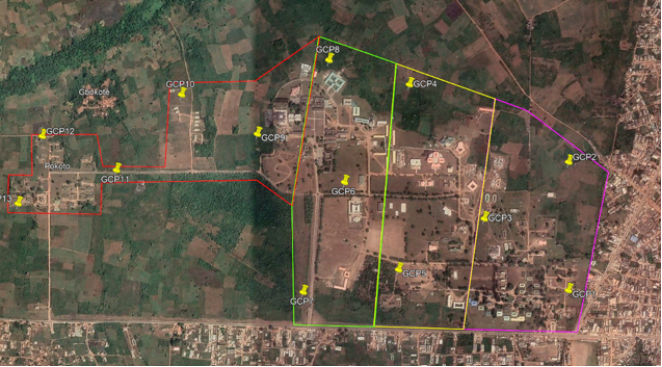
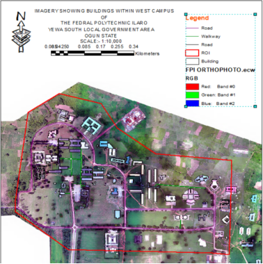
Federal Polytechnic Ilaro, located in Ogun State, Nigeria, is a reputable institution with significant educational and infrastructural assets. Its geocoordinates are latitude 6.8873°N and longitude 2.9875°E. As illustrated by Figure 1, the study area comprises numerous academic, administrative, residential, and utility facilities that support the institution's operations. As this infrastructure expands, various issues related to information system deficiencies, inadequate database architectures, and ineffective management procedures, which complicate matters concerning facility management
[2]
O. A. Alausa and O. S. Adaradohun, “Need for Database Creation on Updated Building Facilities Map of the Federal Polytechnic Ilaro,” Journal of Environmental Spectrum, vol. 3, no. 1, pp. 54–66, 2022.
[2]
. As the institution grows, the need to implement an efficient and comprehensive infrastructure management framework becomes inevitable. Traditional methods of infrastructure documentation and management are often characterized by outdated records, limited spatial integration, and difficulties in monitoring facility conditions, thereby reducing the effectiveness of planning and maintenance activities. Also, the integration of the Unmanned Aerial Vehicle (UAV) with GBII offers a promising solution to these challenges. The combination of these technologies will enable improved spatial data integration, precise information gathering, and improved decision-making processes
[4]
M. Aljarman, H. Boussabaine, and K. Almarri, “Emerging technical risks from the application of building information modelling,” Journal of Facilities Management, vol. 18, no. 3, pp. 195–212, 2020.
Figure 1. Showing a Google Earth imagery of the study area.
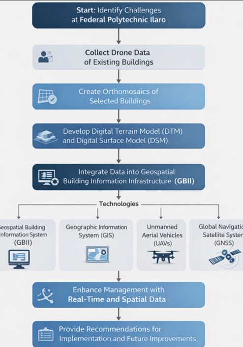
3. Methodology
This study integrates UAVs, GIS, and GBII technologies to address contemporary building management concerns. These concepts will result in accurate and up-to-date information, as well as increased efficacy in infrastructure management. The flow chart is seen in Figure 2 below.
3.1. Planning
The planning stage was undertaken to ensure efficient and accurate geospatial data acquisition. Preliminary reconnaissance of the study area was conducted using Google Earth Pro imagery to identify suitable locations for Ground Control Points (GCPs) and to design the UAV flight path (Figure 3). Before field operations, the institutional boundary data were obtained from the Department of Surveying and Geoinformatics, Federal Polytechnic Ilaro, while the Continuously Operating Reference Station (CORS) data were acquired from the Office of the Surveyor-General, Ogun State. These datasets provided the geodetic framework for establishing GCPs and georeferencing the UAV imagery. Table 1 presents the CORS information used for the survey.
Additionally, a field reconnaissance survey was conducted to assess potential obstacles that could affect UAV operations, including power lines, tall trees, and other structures. Weather conditions, particularly wind speed and direction, were also evaluated to ensure safe and efficient flight operations. Based on the assessment, suitable locations for UAV take-off and landing were selected. No significant obstructions were observed within the study area; therefore, the planned flight mission was executed without modification.
3.2. Instrumentation and Software
The study employed a DJI Phantom 4 Pro V2.0 UAV for aerial image acquisition and a Tersus Oscar GNSS receiver for ground control surveys. Data processing and analysis were carried out on an HP Workstation running Windows 11 using Google Earth Pro, DroneDeploy, Agisoft Metashape, and ArcGIS 10.5. As presented in Table 2.
Table 2. Hardware and Software Used in the Study.
Category
Equipment/Software
Purpose
UAV
DJI Phantom 4 Pro V2.0
Acquisition of high-resolution aerial imagery
GNSS Receiver
Tersus Oscar GNSS Receiver
Establishment of Ground Control Points (GCPs) and georeferencing
Workstation
HP Workstation (Windows 11)
Data processing and analysis
Software
Google Earth Pro
Preliminary reconnaissance and flight planning
Software
DroneDeploy
UAV mission planning and flight execution
Software
Agisoft Metashape
Photogrammetric processing, orthomosaic and DEM generation
Software
ArcGIS 10.5
Spatial analysis, database development, and GIS integration
3.3. Pre-data Acquisition
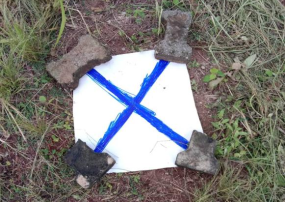
The GCPs were set up in the field as specified in the GCP design plan (see Figure 4 below). The initial step was to secure the prefabricated flex marker at the designated location. Fixing the flex markings made it easier to identify the GCPs from the drone pictures. The Tersus Oscar GNSS (rover) was used to provide precise GCP coordinate measurements. The coordinates were taken from the inside corner of the flex marker, making it easy to locate the GCP point throughout the image analysis process. The precise location of the GCP allowed for reliable geographic reference of the GCP coordinates, which could be used to improve the quality of the orthophotos and DEM.
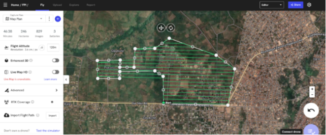
The UAV data collection procedure began with the creation of a flight plan. The project's boundaries were established using Google Earth Pro software and satellite imagery. GCPs were then chosen based on their accessibility, as well as their proximity to areas of interest for adequate coverage. The project perimeter was divided into four flight missions (see Figure 5). Flight parameters were configured within Drone Deploy, including a flight altitude of 120 m, front overlap of 65%, and side overlap of 55%. The UAV survey was subsequently conducted following the predefined flight paths, and high-resolution aerial images were acquired for photogrammetric processing.
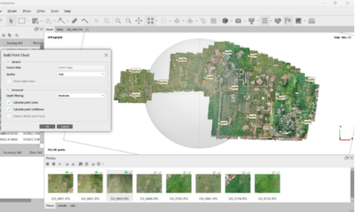
UAV imagery was processed in Agisoft Metashape through image alignment, GCP integration, dense point cloud generation, and the production of orthomosaics and Digital Elevation Models (DEMs). RTK-derived GCP coordinates were incorporated to improve georeferencing accuracy. Figure 6 illustrates the dense point cloud generated from the aligned images.
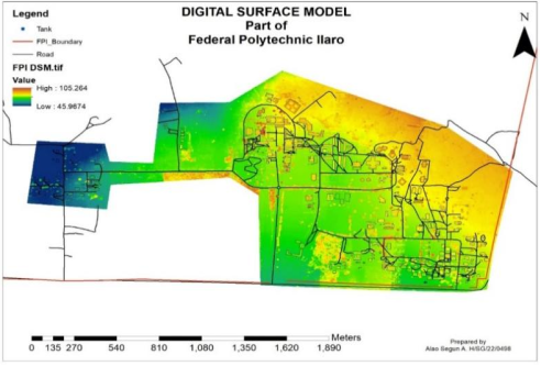
The major outputs of this study include a Digital Elevation Model (DEM), Digital Surface Model (DSM), Orthomosaic map, and a geospatial database containing attribute information for campus buildings and infrastructure. The DSM was generated by processing the dense point cloud, which captured all visible surface features, including vegetation and buildings.
The DSM shows information about natural and artificial features of the landscape with their elevations, the landscapes’ high and lowlands etc. The high spatial resolution of the DSM enabled detailed visualization of the campus landscape and its topographic variations. such as ridges, furrows, rivers etc.
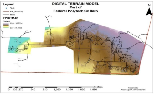
The DTM shows the bare ground topography of the surface of the study area, excluding all natural (vegetation, land forms, etc.) and artificial (buildings, roads, etc.) features, which are essential for terrain analysis. The DTM supports hydrological modelling by showing water flow, watershed analysis, and flood modelling. It is used for drainage network planning by showing the movement of water across the terrain. It’s also suitable for assessing terrain suitability for building and development by town planners. A good understanding of the influence of the terrain on natural hazards such as floods, landslides, and erosion can be effectively assessed.
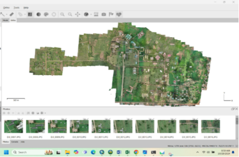
A georeferenced orthomosaic map was generated by mosaicking the aligned UAV images. The orthomosaic provides a high-resolution and spatially accurate representation of the study area, enabling detailed visualization and mapping of campus infrastructure. The generated orthomosaic serves as a reliable base map for infrastructure inventory, monitoring, and spatial analysis.
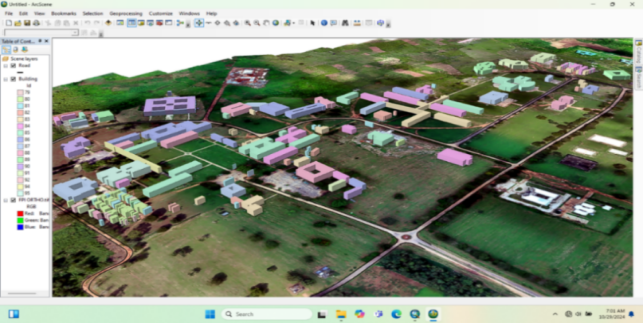
Figure 11. Integrated model of building information in campus overlayed on Orthophoto of the campus.
4.1. Attribute Data Organization
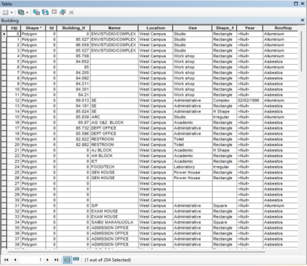
This involved organizing the characters of every building as a feature through shapefile creation to house all the data about every building detail in the ArcGIS environment.
All the collated attributes for the buildings were neatly organized using ArcGIS structured query language (SQL) with their contents properly tagged with special codes. Figure 12 shows the query result of building within the west campus. This query will help the management decision-making process over buildings within the school.
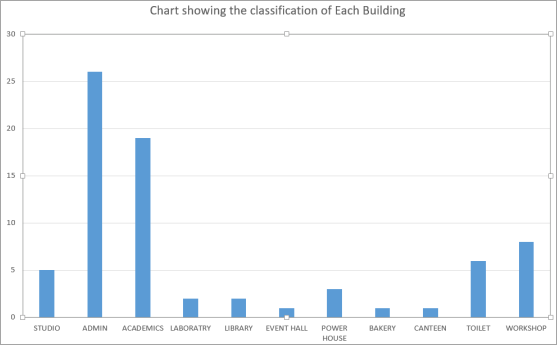
Figure 13. Chart of the Building within the West Campus.
Figure 13 shows the number of buildings on the west campus of the institution. There are 5 studios, 26 Administrative buildings, 19 Academic buildings, 8 workshops, a Library and its extension, 2 laboratories, 6 Toilets, 3 power houses, 1 bakery, 1 canteen, and an event hall.
4.2. Discussion
The results demonstrate the effectiveness of integrating UAV-derived geospatial data with GIS and Geospatial Building Information Infrastructure (GBII) for infrastructure mapping and management, a total of 74 buildings were covered on the west campus, the academic buildings covered about 38%, and the administrative buildings about 26%. The generated DSM, DTM, orthomosaic, and geospatial database collectively provide a comprehensive framework for visualizing, analyzing, and managing campus infrastructure.
The DSM and DTM successfully captured the surface and terrain characteristics of the study area, respectively. While the DSM facilitated the assessment of elevation variations and the spatial relationship between infrastructure and surrounding terrain, the DTM provided a representation of the bare-earth surface suitable for terrain characterization and environmental assessment. These findings agree with previous studies that identified terrain models as essential tools for infrastructure planning, drainage analysis, and hazard assessment
[3]
M. E. N. O. Ali, L. G. E.-D. Taha, M. H. A. Mohamed, and A. A. Mandouh, “Generation of digital terrain model from multispectral LiDar using different ground filtering techniques,” The Egyptian Journal of Remote Sensing and Space Science, vol. 24, no. 2, pp. 181–189, 2021.
B. Lv, J. Liu, P. Wang, and M. Yasir, “DSM generation from multi-view high-resolution satellite images based on the photometric mesh refinement method,” Remote Sensing, vol. 14, no. 24, 2022.
The orthomosaic provided a high-resolution and georeferenced representation of the campus environment, enabling accurate identification and mapping of existing infrastructure. Its spatial accuracy supports infrastructure inventory, monitoring, and change detection, thereby improving the quality of spatial information available for campus planning and management. Similar studies have highlighted the usefulness of UAV-derived orthomosaics for infrastructure monitoring and spatial decision-making
[9]
B. Lv, J. Liu, P. Wang, and M. Yasir, “DSM generation from multi-view high-resolution satellite images based on the photometric mesh refinement method,” Remote Sensing, vol. 14, no. 24, 2022.
Furthermore, the integration of spatial and attribute data within a GIS environment enhanced the management of campus infrastructure information. The developed geospatial database enabled the organization to visualize and query building attributes, providing a structured framework for evidence-based decision-making. The inventory analysis revealed a diverse distribution of educational, administrative, and utility facilities across the campus, emphasizing the need for an integrated information system capable of managing both spatial and non-spatial datasets.
Overall, the findings confirm that the integration of UAV, GIS, and GBII technologies provides an efficient approach for infrastructure management. The developed framework improves data accessibility, supports informed decision-making, and offers a sustainable alternative to conventional infrastructure management practices within tertiary institutions.
5. Limitations
Although the proposed UAV-GIS-GBII framework proved effective for infrastructure mapping and management, the study was limited to using static spatial datasets acquired during a single survey campaign. Consequently, the developed system does not support real-time monitoring or temporal analysis of infrastructure changes. Future studies may incorporate multi-temporal UAV surveys and real-time data acquisition technologies to enhance infrastructure monitoring and decision-making capabilities.
6. Conclusion
This study developed an integrated Geospatial Building Information Infrastructure (GBII) for the West Campus of Federal Polytechnic Ilaro using UAV and GIS technologies. High-resolution geospatial products, including a Digital Surface Model (DSM), Digital Terrain Model (DTM), orthomosaic imagery, and a geospatial database, were generated to support infrastructure mapping and management. The integration of spatial and attribute data provided an effective framework for infrastructure inventory, visualization, and decision-making. The findings demonstrate the potential of UAV-GIS-GBII integration as a reliable and cost-effective approach for enhancing infrastructure management in tertiary institutions. Figure 13 depicts the details of this analysis.
Abbreviations
BIM
Building Information Modelling
GBII
Geospatial Building Information Infrastructure
GIS
Geographic Information System(s)
UAV
Unmanned Aerial Vehicle(s) (Drone Technology)
GNSS
Global Navigation Satellite System
GPS
Global Positioning System
GLONASS
Global Navigation Satellite System (Russia)
BeiDou
Beidou Navigation Satellite System (China)
Galileo
European Global Navigation Satellite System
DTM
Digital Terrain Model
DSM
Digital Surface Model
DEM
Digital Elevation Model
FME
Feature Manipulation Engine
LiDAR
Light Detection and Ranging
3D
Three-dimensional
Author Contributions
Alausa Olalekan: Data Curation, Visualization, Writing – original draft
Y. A. Ahmed, H. M. F. Shehzad, M. M. Khurshid, O. H. Abbas Hassan, S. A. Abdalla, and N. Alrefai, “Examining the effect of interoperability factors on building information modelling (BIM) adoption in Malaysia,” Construction Innovation, vol. 24, no. 2, pp. 606–642, 2024.
O. A. Alausa and O. S. Adaradohun, “Need for Database Creation on Updated Building Facilities Map of the Federal Polytechnic Ilaro,” Journal of Environmental Spectrum, vol. 3, no. 1, pp. 54–66, 2022.
[3]
M. E. N. O. Ali, L. G. E.-D. Taha, M. H. A. Mohamed, and A. A. Mandouh, “Generation of digital terrain model from multispectral LiDar using different ground filtering techniques,” The Egyptian Journal of Remote Sensing and Space Science, vol. 24, no. 2, pp. 181–189, 2021.
M. Aljarman, H. Boussabaine, and K. Almarri, “Emerging technical risks from the application of building information modelling,” Journal of Facilities Management, vol. 18, no. 3, pp. 195–212, 2020.
S. Ecke, F. Stehr, J. Frey, D. Tiede, J. Dempewolf, H.-J. Klemmt, E. Endres, and T. Seifert, “Towards operational UAV-based forest health monitoring: Species identification and crown condition assessment by means of deep learning,” Computers and Electronics in Agriculture, vol. 219, 2024.
International Air Transport Association (IATA), “Global Navigation Satellite System (GNSS),” USA, 2024.
[7]
J. Kan, “The application of building information modeling in large scale railway integrated transportation hubs,” Theoretical and Natural Science, 2025.
[8]
K. Karbasishargh, M. M. Esfandabadi, and A. Esmaeili, “Innovative approaches to UAV performance: Enhancing safety, reliability, and flexibility,” International Journal of Reliability, Risk and Safety, 2024.
[9]
B. Lv, J. Liu, P. Wang, and M. Yasir, “DSM generation from multi-view high-resolution satellite images based on the photometric mesh refinement method,” Remote Sensing, vol. 14, no. 24, 2022.
J. O. Ndubuisi, G. Adene, T. B. Sunday, and E. C. Mbonu, “Development and implementation of Building Site Information Management,” World Journal of Advanced Research and Reviews, vol. 21, no. 2, pp. 1127–1135, 2024.
B. Saad Alotaibi, A. Waqar, D. Radu, A. M. Khan, Y. Dodo, F. Althoey, and H. Almujibah, “Building information modeling (BIM) adoption for enhanced legal and contractual management in construction projects,” Ain Shams Engineering Journal, vol. 15, no. 7, 2024.
V. F. Saraiva Landim, J. Poças Martins, and D. Calvetti, “From BIM to UAVs: A systematic review of digital solutions for productivity challenges in construction,” Applied Sciences, vol. 15, no. 19, 2025.
M. J. Sobouti, A. Mohajerzadeh, H. Y. Adarbah, Z. Rahimi, and H. Ahmadi, “Utilizing UAVs in wireless networks: Advantages, challenges, objectives, and solution methods,” Vehicles, vol. 6, no. 4, pp. 1769–1800, 2024.
M. Tkác and P. Mésároš, “Utilizing drone technology in civil engineering,” Selected Scientific Papers – Journal of Civil Engineering, vol. 14, pp. 27–37, 2019.
A. Waqar, I. Othman, N. Saad, M. Azab, and A. M. Khan, “BIM in green building: Enhancing sustainability in small construction projects,” Cleaner Environmental Systems, vol. 11, no. 3, pp. 329–346, 2023.
W. Wan Abdul Basir, U. Ujang, and Z. Bin Majid, “Building information modeling (BIM) and geographic information system (GIS) data compatibility for construction projects,” Journal of Information System and Technology Management, vol. 6, no. 24, pp. 278–289, 2021.
Olalekan, A., Monsur, A., Ademola, L., Oluwayemisi, A., Oluwadamilare, O., et al. (2026). Drone-Enabled Geospatial Infrastructure Management for Buildings at the Federal Polytechnic Ilaro. American Journal of Remote Sensing, 14(1), 13-24. https://doi.org/10.11648/j.ajrs.20261401.12
Olalekan A, Monsur A, Ademola L, Oluwayemisi A, Oluwadamilare O, et al. Drone-Enabled Geospatial Infrastructure Management for Buildings at the Federal Polytechnic Ilaro. Am J Remote Sens. 2026;14(1):13-24. doi: 10.11648/j.ajrs.20261401.12
@article{10.11648/j.ajrs.20261401.12,
  author = {Alausa Olalekan and Adewara Monsur and Lasisi Ademola and Adaradohun Oluwayemisi and Ogundele Oluwadamilare and Oladunjoye Abdurrahman},
  title = {Drone-Enabled Geospatial Infrastructure Management for Buildings at the Federal Polytechnic Ilaro},
  journal = {American Journal of Remote Sensing},
  volume = {14},
  number = {1},
  pages = {13-24},
  doi = {10.11648/j.ajrs.20261401.12},
  url = {https://doi.org/10.11648/j.ajrs.20261401.12},
  eprint = {https://article.sciencepublishinggroup.com/pdf/10.11648.j.ajrs.20261401.12},
  abstract = {This paper discusses the development of the Geospatial Building Information Infrastructure (GBII) for the developing Federal Polytechnic in Ilaro, Nigeria. It demonstrates how participants in interdisciplinary building projects, such as surveyors, engineers, and architects, can collaborate effectively using the same digital model. Model visualization and design coordination improve when data from multiple sources are merged into a single model. This allows for more informed decisions about costs and resource allocation. To obtain high-quality geospatial data, Global Navigation Satellite System (GNSS) surveying techniques were combined with Unmanned Aerial Vehicle (UAV) data captured. Field surveys were first carried out to maximize the effectiveness of the flight procedure and establish the best placement of GCPs. Preliminary satellite imagery analysis helped design UAV flight paths and select the potential GCP location in the study area. Before data collection, the instrument's test was done to ensure its good working condition. Spatial datasets were collected using a Tarsus Oscar GNSS device for the GCPs and a DJI Phantom 4 Pro V2 UAV for the aerial photos. Digital surface model (DSM) and Digital terrain model (DTM) maps were derived from the image processed using the software. The output maps reveal images of surfaces and the topography. All acquired datasets were visualized using the ArcGIS 10.6 system for mapping and analysis. The incorporation of UAV data in GBII improved data accuracy and visualization, and it has proven to be an efficient method.},
 year = {2026}
}
TY  - JOUR
T1  - Drone-Enabled Geospatial Infrastructure Management for Buildings at the Federal Polytechnic Ilaro
AU  - Alausa Olalekan
AU  - Adewara Monsur
AU  - Lasisi Ademola
AU  - Adaradohun Oluwayemisi
AU  - Ogundele Oluwadamilare
AU  - Oladunjoye Abdurrahman
Y1  - 2026/06/27
PY  - 2026
N1  - https://doi.org/10.11648/j.ajrs.20261401.12
DO  - 10.11648/j.ajrs.20261401.12
T2  - American Journal of Remote Sensing
JF  - American Journal of Remote Sensing
JO  - American Journal of Remote Sensing
SP  - 13
EP  - 24
PB  - Science Publishing Group
SN  - 2328-580X
UR  - https://doi.org/10.11648/j.ajrs.20261401.12
AB  - This paper discusses the development of the Geospatial Building Information Infrastructure (GBII) for the developing Federal Polytechnic in Ilaro, Nigeria. It demonstrates how participants in interdisciplinary building projects, such as surveyors, engineers, and architects, can collaborate effectively using the same digital model. Model visualization and design coordination improve when data from multiple sources are merged into a single model. This allows for more informed decisions about costs and resource allocation. To obtain high-quality geospatial data, Global Navigation Satellite System (GNSS) surveying techniques were combined with Unmanned Aerial Vehicle (UAV) data captured. Field surveys were first carried out to maximize the effectiveness of the flight procedure and establish the best placement of GCPs. Preliminary satellite imagery analysis helped design UAV flight paths and select the potential GCP location in the study area. Before data collection, the instrument's test was done to ensure its good working condition. Spatial datasets were collected using a Tarsus Oscar GNSS device for the GCPs and a DJI Phantom 4 Pro V2 UAV for the aerial photos. Digital surface model (DSM) and Digital terrain model (DTM) maps were derived from the image processed using the software. The output maps reveal images of surfaces and the topography. All acquired datasets were visualized using the ArcGIS 10.6 system for mapping and analysis. The incorporation of UAV data in GBII improved data accuracy and visualization, and it has proven to be an efficient method.
VL  - 14
IS  - 1
ER  -