1. Introduction
1.1. Background of the Study
Climate change is an ongoing process that occurs gradually but steadily over time, leading to changes in hydrological, climatological, and meteorological factors around the world
| [1] | IPCC 2023 Intergovernmental Panel on Climate Change (IPCC) releases its next report titled "Climate Change 2023: The Physical Science Basis. |
[1]
. The Intergovernmental Panel on Climate Change (IPCC) reports that the average global surface temperature has risen by 0.6 ± 0.2°C since 1861, with an expected increase of 2 to 4°C over the next century
| [2] | IPCC (2007) Climate Change 2007: Impacts, Adaptation and Vulnerability. Contribution of Working Group II to the Fourth Assessment Report of the Intergovernmental Panel on Climate Change (IPCC). |
[2]
.
Rainfall is a crucial meteorological factor, serving as the primary source water in many world regions. It is therefore essential for various human activities, including agriculture and industry
. Rainfall serves as a crucial factor in various hydrologic and flood risk models
| [4] | Santos R, Fernandes L S, Moura J, Pereira M and Pacheco F 2014 The impact of climate change, human interference, scale and modeling uncertainties on the estimation of aquifer properties and river flow components J. Hydrol. 519 1297-314. https://doi.org/10.1016/j.jhydrol.2014.09.001 |
| [5] | Terêncio D, Fernandes L S, Cortes R and Pacheco F 2017 Improved framework model to allocate optimal rainwater harvesting sites in small watersheds for agro-forestry uses J. Hydrol. 550 318-30. |
| [6] | Terêncio D, Fernandes L S, Cortes R, Moura J and Pacheco F 2018 Rainwater harvesting in catchments for agro-forestry uses: A study focused on the balance between sustainability values and storage capacity Sci. Total Environ. 613 1079-92. https://doi.org/10.1016/j.jhydrol.2017.05.003 |
[4-6]
, highlighting its importance. Rainfall is defined by two main characteristics: duration and intensity. Changes in either of these characteristics can lead to significant natural disasters
, such as floods and droughts. A major effect of climate change on rainfall is the alteration of both the timing and amount of rainfall in a given area, underscoring the necessity to examine its changing patterns over time using historical data and to predict future trends for timely preparedness, particularly in regions that are already experiencing water scarcity
| [8] | Balasmeh O, Babbar R and Karmaker T 2019 Trend analysis and ARIMA modeling for forecasting precipitation pattern in Wadi Shueib catchment area in Jordan. Arab J Geosci. https://doi.org/10.1007/s12517-018-4205-z |
[8]
.
In Eastern Africa, the timing of the growing period, including its onset and cessation, is critical for agricultural inputs because the GDPs of many countries in this region are sensitive to climate and influenced by variability in rainfall patterns
| [9] | Palmer P I, Wainwright C M, Dong B, Maidment R I, Wheeler K G, Gedney N, Hickman J E, Madani N, Folwell S S, Abdo G, and others 2023 Drivers and impacts of Eastern African rainfall variability Nat. Rev. Earth Environ. 4 254-70. https://doi.org//s43017-023-00397-x |
| [10] | Abera W M and Wen W 2021 Interannual variability of seasonal rainfall and associated circulations over Gambella, Ethiopia Int J Env. Monit Anal 9 67-95. |
[9, 10]
. In Ethiopia, rainfall exhibits significant spatial and temporal variation in terms of both amount and distribution, influenced by topography, atmospheric circulation, and the seasonal migration of the intertropical convergence zone (ITCZ)
| [11] | Asaye T S, Amare Z Y, Geremew B B and Abebe M G 2025 Rainfall variability and trends in western Amhara: implication for sustainable water management and agricultural productivity Water Pract. Technol. wpt2025023. https://doi.org/10.2166/wpt.2025.023 |
[11]
. The quantity, timing of onset and cessation, and duration of the growing season, along with the seasonal rainfall cycle, show spatial differences, while trends in rainfall can change over time, ranging from days to decades and across seasons
| [12] | Asaye T S, Amare Z, Geremew B B and Abebe M G 2025 Spatiotemporal trend analysis of rainfall for deeper understanding of the pattern and its implications over western Amhara, Ethiopia: innovative trend analysis method Discov. Sustain. 6 253. https://doi.org/10.1007/s43621-025-00900-y |
[12]
. This suggests that climate factors greatly affect both annual and seasonal rainfall patterns at a localized level, typically within a small geographic area. Consequently, the intricate spatial and temporal variability of climate parameters throughout the country, particularly in Gojjam, is quite complex. Moreover, prior research has not examined the spatial variability and characterize of seasonal and annual rainfall. This study intends to address these gaps by providing a comprehensive assessment of the spatial variability of seasonal and annual rainfall utilizing meteorological station data and a rigorous methodology. Additionally, it aims to characterize seasonal rainfall regarding its onset and cessation.
1.2. Objective
1.2.1. General Objective
The main objective of this study is to characterize and assess the spatial variability and temporal trends of seasonal and annual rainfall in Gojjam, Ethiopia.
1.2.2. Specific Objectives
The specific objectives of the study were:
1) To assess spatial distribution of seasonal and annual rainfall over the study area.
2) To assess the variability of seasonal and annual rainfall of the study area.
3) To characterize the onset and cessation date over the study areas.
2. Data and Methodology
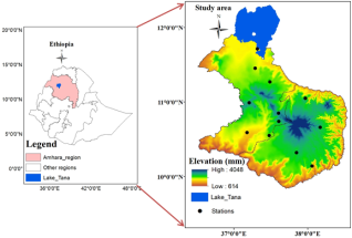
2.1. Description of Study Area
Gojjam is located in the northwestern part of Ethiopia, within the Amhara region of Eastern Africa, positioned between 9
0 83'N and 12
0 29' N latitudes and 36
0 52' and 38
0 53'E longitudes (
Figure 1). The region spans approximately 28,076 km² and has a population of 4,260,394
| [13] | Anon 2007 Statistical Agency (2007) The Federal Democratic Republic of Ethiopia - Amhara. Source data: NationalStatistical Agency (Ethiopia), GeoHive website. No Title. |
[13]
. This area is notable for lying completely within the curve of the River Gihon (Blue Nile). Gojjam shares its borders with Gonder to the north, Wolo to the east, Awi to the west, and Welega and Shewa to the south. Depending on the administrative structure of the country, Gojjam is divided into three zones: north, east, and west Gojjam. A digital elevation model of the region reveals that the altitudes range from a low of 639 m at the borders to a high of 4048 m in the central area. The landscape of Gojjam is split into two sections: the highlands and the lowlands. The highlands are situated at elevations exceeding 1,800 meters and cover the majority of the central and western areas of the study area. Among the extensive and rugged mountain ranges and plateaus in the area, Choke (4048 m) stands as the tallest and is believed to be the origin of the Blue Nile (
Figure 1).
The climate of Gojjam, Ethiopia, is primarily influenced by the seasonal shifts of the Inter-tropical Convergence Zone (ITCZ), which is impacted by the area's complex topographical features, as well as the Earth's orientation in relation to the sun and the consequent air circulation patterns
. The warmest months in much of the area fall in April and May, just before the main rainy season, when the abundant cloud cover diminishes solar radiation
| [15] | Getahun Y S 2012 Spatial-temporal analyses of climate elements, vegetation characteristics and sea surface temperature anomaly. A Case study in Gojam, Ethiopia PhD Thesis. |
[15]
. The Gojjam sub region experiences a single rainy season during specific months, referred to as the
Kiremt (summer) season, which lasts from June to September, while the other months, known as the dry seasons, are locally identified as
Bega and the transitional
Belg (mid-February to May)
| [16] | NMSA 1996 Climatic and agroclimatic resources of Ethiopia. Natl. Meteorol. Serv. Agency of Ethiopia, Meteorol. Res. Rep. Ser., 1(1), 1-137. |
[16]
.
Figure 1. Study area and data points.
2.2. Data Source
The daily rainfall data for twelve stations, covering the period from 1991 to 2020, was obtained from the Western Amhara Meteorological Service Center in Bahir Dar. Due to some stations having incomplete records, this issue was resolved by filling in the gaps with ENACTS data obtained from EMI through R scripts. Subsequently, data quality control procedures were applied to clean and standardize the dataset for further analysis. To evaluate data quality, quartile outlier detection methods and the Standard Normal Homogeneity Test (SNHT) were employed. Quartile recognized as an effective outlier detection approach
| [11] | Asaye T S, Amare Z Y, Geremew B B and Abebe M G 2025 Rainfall variability and trends in western Amhara: implication for sustainable water management and agricultural productivity Water Pract. Technol. wpt2025023. https://doi.org/10.2166/wpt.2025.023 |
[11]
, was utilized to identify anomalies in daily precipitation data, while the meteorological time series was analyzed for non-homogeneity using the Standard Normal Homogeneity Test (SNHT). The homogeneity test is essential for studies on climate and trends, as non-climatic factors can interfere with climate data and influence research findings
. Another important task is identifying and eliminating non-climatic in homogeneities. Among the various statistical homogeneity tests, SNHT is frequently utilized to assess climate data (such as temperature and rainfall) due to weak correlations between measurement stations
| [18] | González-Rouco J F, Jiménez J L, Quesada V and Valero F 2001 Quality control and homogeneity of precipitation data in the southwest of Europe J. Clim. 14 964-78. https://doi.org/10.1175/1520-0442 |
[18]
. The absence of significant change points or inhomogeneity in the test results indicated that mean adjustments were unnecessary; consequently, the original dataset was employed for further analysis. The Climate Data Tool (CDT) aided in reviewing the SNHT and identifying outlier results.
2.3. Methods for Rainfall Variability Assessment
The variability of seasonal rainfall was assessed by employing the coefficient of variation (CV), the Precipitation Concentration Index (PCI), and the Standard Anomaly Index (SAI).
Coefficient of variation
The assessment of variability in seasonal and annual rainfall data is conducted using the coefficient of variation (CV). The coefficient of variation is applied to investigate both inter-annual and intra-annual fluctuations in rainfall. Elevated CV values indicate a greater degree of variability in the rainfall time-series data. To quantify the level of variability, the coefficient of variation (CV) was calculated as the ratio of the standard deviation (
) to the mean of the specified time series, expressed as a percentage
| [11] | Asaye T S, Amare Z Y, Geremew B B and Abebe M G 2025 Rainfall variability and trends in western Amhara: implication for sustainable water management and agricultural productivity Water Pract. Technol. wpt2025023. https://doi.org/10.2166/wpt.2025.023 |
| [19] | Alemu M M and Bawoke G T 2020 Analysis of spatial variability and temporal trends of rainfall in Amhara region, Ethiopia J. Water Clim. Change 11 1505-20. https://doi.org/10.2166/wcc.2019.084 |
| [20] | Harka A E, Jilo N B and Behulu F 2021 Spatial-temporal rainfall trend and variability assessment in the Upper Wabe Shebelle River Basin, Ethiopia: Application of innovative trend analysis method J. Hydrol. Reg. Stud. 37 100915. https://doi.org/10.1016/j.ejrh.2021.100915 |
[11, 19, 20]
.
Where: CV (%) denotes the coefficient of variation for rainfall data across seasonal and annual periods.
represents the standard deviation of rainfall at both seasonal and annual timescales, while
indicates the mean rainfall for those same timescales at specific grid points. CV values were classified as less (CV < 20%), moderate (20% < CV < 30%), high (30% < CV < 40%), and very high (CV > 40%)
| [11] | Asaye T S, Amare Z Y, Geremew B B and Abebe M G 2025 Rainfall variability and trends in western Amhara: implication for sustainable water management and agricultural productivity Water Pract. Technol. wpt2025023. https://doi.org/10.2166/wpt.2025.023 |
| [20] | Harka A E, Jilo N B and Behulu F 2021 Spatial-temporal rainfall trend and variability assessment in the Upper Wabe Shebelle River Basin, Ethiopia: Application of innovative trend analysis method J. Hydrol. Reg. Stud. 37 100915. https://doi.org/10.1016/j.ejrh.2021.100915 |
[11, 20]
.
Standardized Anomaly Index
An alternate method for evaluating rainfall variability is the standardized anomaly index (SAI), which helps identify both dry and wet years within the dataset and provides a comprehensive analysis of trends
| [20] | Harka A E, Jilo N B and Behulu F 2021 Spatial-temporal rainfall trend and variability assessment in the Upper Wabe Shebelle River Basin, Ethiopia: Application of innovative trend analysis method J. Hydrol. Reg. Stud. 37 100915. https://doi.org/10.1016/j.ejrh.2021.100915 |
[20]
. This index serves to assess rainfall variability and indicates how many standard deviations a rainfall event deviates from the average. Its calculation is as follows:
Where x represents the annual rainfall, μ signifies the mean annual rainfall, and δ refers to the standard deviation of annual rainfall. A negative SAI value in Equation
2 compared to the chosen reference period indicates a dry spell (below normal precipitation), while a positive value indicates a wet condition (above normal rainfall).
Table 1. Classification and description of standardized rainfall anomaly index
Category | SAI-values |
Extremely dry | -2.00 |
Severely dry | -1.99 -1.50 |
Moderately dry | -1.49 -1.00 |
Near normal | -0.99 0.99 |
Moderately wet | 1.00 1.49 |
Severely wet | 1.50 1.99 |
Extremely wet | 2.00 |
Source
| [21] | Koudahe K, Kayode A J, Samson A O, Adebola A A, Djaman K, and others 2017 Trend analysis in standardized precipitation index and standardized anomaly index in the context of climate change in Southern Togo Atmospheric Clim. Sci. 7 401. |
[21]
Precipitation Concentration Index
In order to evaluate the seasonal patterns of rainfall, a revised version of Oliver
precipitation concentration index (PCI) was utilized. Gocic
describe this index as one that illustrates the distribution of monthly rainfall data and serves as an indicator for both floods and droughts. The computation of PCI was outlined by De Luis
| [24] | De Luis M, Raventós J, González-Hidalgo J, Sánchez J and Cortina J 2000 Spatial analysis of rainfall trends in the region of Valencia (East Spain) Int. J. Climatol. J. R. Meteorol. Soc. 20 1451-69. https://doi.org/10.1002/1097-0088 |
[24]
in the following manner:
In the ith month, Pi denotes the quantity of rainfall measured for that month. According to Oliver
, PCI values below 10 indicate a consistent monthly rainfall pattern, values ranging from 11 to 16 reflect a moderate distribution of rainfall, and values between 16 and 20 suggest an irregular monthly rainfall pattern and values at 20 or higher indicate a significantly high concentration of rainfall. Therefore, an increase in PCI values over time signifies a growing variability in the distribution of monthly rainfall.
Season’s percentage of contribution to the annual rainfall
In Gojjam, there are three distinct seasons. These are Kiremt (July to September), the primary rainy season; Bega (October to January), the dry season and Belg (February to May), the transitional season. It is essential to compute the percentage of rainfall contributed by each season to the annual total for each station located in the study area, calculated as follows:
Where PC was percentage of contribution in percent, was long term seasonal rainfall of each station and was the long term annual mean rainfall.
2.4. Characterizing Seasonal Rainfall
The quality-controlled rainfall data was organized used in Ms-excel 2010 spread sheet following the days of the year (DOY) entry format. Then, the daily rainfall data was subjected for detail analysis using sequences of statistical packages. The appropriate onset date (OD), cessation date (CD), and length of growing period (LGP) was calculated and simulated by using CDT tool
. The onset date was calculated based on the criteria that, the day that recorded 20mm of rainfall over five consecutive days without being followed by a dry spell longer than seven days within 21 days of planting day and with at least three rainy days on which threshold for rainy day (>=0.85mm)
. This was done so as to capture both the early start and the late start. The condition that there should be no 7-day dry period is to ensure there is no false start
. End of the growing season is the first occasion when the water balance drops to zero after the end of rains
| [26] | Zeleke A, Tesfaye K, Tadesse T, Alem T, Ademe D and Adgo E 2023 Spatiotemporal analysis of rainfall and temperature variability and trends for climate resilient maize farming system in major agroecology zones of northwest Ethiopia Int. J. Agric. Sustain. 21 2255450. https://doi.org/10.1080/14735903.2023.2255450 |
[26]
. In this study the end of the rainy season was calculated by using CDT tool with the criteria that, when water balance drops below 5mm for a period of three days
. The length of the growing season (LGP) for the main rainy season was determined the number of days between the onset and cessation dates using equation (
5).
(5)
3. Result
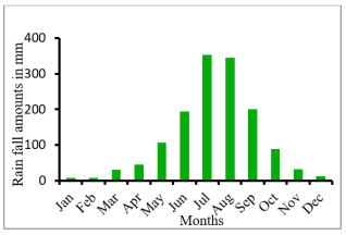
3.1. Rainfall Climatology and Its Distribution
The annual rainfall cycle in the study area exhibits a unimodal pattern, meaning that there is a single distinct peak in precipitation throughout the year. This peak typically occurs in the month of July, which represents the highest point of rainfall intensity within the annual cycle (
Figure 2). Following the peak in July, the region experiences a gradual decline in rainfall. The dry season in the area extends from October to January, a period that is locally referred to as the "
Bega" season. This phase is characterized by minimal rainfall and often coincides with cooler temperatures and clear skies. Another relatively drier period occurs from February to May, commonly known as the "
Belg" season. Although
Belg may receive some rainfall, it is significantly less compared to the peak rainy month of July. Together, these seasonal patterns define the unique rainfall distribution of the region and play a critical role in influencing local agriculture, water availability, and overall climate dynamics.
Figure 2. Annual Rainfall Cycle in Gojjam.
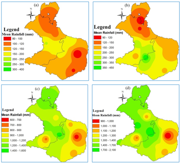
3.2. Seasonal and Annual Rainfall Distribution
The regional distribution of both seasonal and annual rainfall across the study area, covering the years 1991 to 2020, is illustrated in
Figure 3 (a-d). The data reveal significant spatial variability in precipitation across different zones within the western Amhara region.
Figure 3a highlights that the western and northern sections of the study area experience the highest and lowest rainfall, respectively. As shown in
Figure 3a, the western portion of the study area receives the highest rainfall during this dry season, with totals ranging from 150 mm to 300 mm. Meanwhile, the northern and northeastern zones experience minimal rainfall, often between 80 mm and 120 mm. The
Bega season is dominated by hot, dry days and cooler nights, a climatic pattern are documented
| [16] | NMSA 1996 Climatic and agroclimatic resources of Ethiopia. Natl. Meteorol. Serv. Agency of Ethiopia, Meteorol. Res. Rep. Ser., 1(1), 1-137. |
[16]
. This season is largely controlled by dry air masses originating from two primary high-pressure systems: the Saharan anticyclone and the Siberian high. In highland areas,
Bega conditions often include occasional occurrences of frost, especially during the early morning hours. In rare cases, unseasonal rainfall may occur during
Bega due to the intrusion of low-pressure systems originating from the Mediterranean. When these systems migrate southward and interact with tropical systems, they disrupt the prevailing northeasterly wind patterns, leading to unexpected precipitation events in northwestern parts of Ethiopia.
During the
Belg season, the southern and western parts of Gojjam received a significant amount of rainfall, ranging between 200 to 450 millimeters
Figure 3b. This indicates a relatively wet period in these regions, which could have positive implications for agricultural activities and water availability. In contrast, the northern parts of the study area experienced substantially lower rainfall during the same period (90 mm -150 mm). This disparity in precipitation levels highlights a notable spatial variation in rainfall distribution, which may have important consequences for crop production, water resources, and overall livelihoods in the northern regions.
During the
Kiremt season (main rainy season) most of the central, northern, and western zones of Amhara receive substantial rainfall. As illustrated in
Figure 3c, rainfall during this period ranges from 1000 mm to 1,400 mm in most locations. However, the northern and northeastern sub-regions of western Amhara receive comparatively less rainfall during the same season, typically between 600 mm and 1000 mm. The
Kiremt season generally begins in June and lasts for approximately three to four months. This seasonal rainfall is largely driven by the Inter-Tropical Convergence Zone (ITCZ) and is influenced by the convergence of low-pressure systems, as noted by
.
The long-term average, annual rainfall in this region ranges geographically from approximately 900 mm to 2,100 mm. This wide range indicates notable differences in climatic conditions across various parts of the region (
Figure 3d). The area mean annual rainfall is 1397.7 mm. The western, central and northern sections of the study area experience the greater rainfall distribution than other parts of study area (
Figure 3d). These climatic patterns underline the complexity of rainfall distribution in Gojjam and highlight the significant role of geographical and atmospheric influences on regional precipitation dynamics.
Figure 3. Spatial distribution of mean rainfall a) Bega; b) Belg; c) Kiremt and d) Annual.
During the
Bega,
Belg, and
Kiremt seasons, the mean rainfall recorded was 135.4 mm, 207.2 mm, and 1072.4 mm, respectively
(
Table 2). These seasonal rainfall amounts contributed significantly to the total annual rainfall, with
Bega accounting for 9.7%,
Belg for 15.0%, and
Kiremt making up the largest share at 76.3% (
Table 2).
Among the three seasons, the
Kiremt season emerged as the primary contributor to annual precipitation, reflecting a rainfall pattern that closely mirrors the distribution of rainfall throughout the entire year. This dominance underscores the critical importance of the
Kiremt season for water resources, agriculture, and overall climatic conditions in the region. The pattern of rainfall observed during the
Kiremt season was consistent with the overall annual rainfall patterns. This correlation was also noted by Seleshi
and Ayalew
| [27] | Ayalew D, Tesfaye K, Mamo G, Yitaferu B and Bayu W 2012 Variability of rainfall and its current trend in Amhara region, Ethiopia Afr. J. Agric. Res. 7 1475-86. https://doi.org/10.5897/AJAR11.698 |
[27]
, who showed that in the Amhara Regional State of Ethiopia, the
Kiremt and
Belg seasons accounted for 74.3% and 5-30%, respectively, of the total annual rainfall.
Table 2. Annual and seasonal mean rainfall (mm) and it contribution (1991-2020).
| Annual | Bega | Belg | Kiremt |
Grid Points | Mean | Mean | % Cont. | Mean | % Cont. | Mean | % Cont. |
Adet | 1157.7 | 108.5 | 9.4 | 120.7 | 10.4 | 928.8 | 80.2 |
Bahir Dar | 1376.9 | 100.4 | 7.3 | 114.4 | 8.3 | 1162.1 | 84.4 |
Deber Markos | 1283.5 | 121.2 | 9.4 | 230.1 | 17.9 | 932.3 | 72.6 |
Deber Work | 903.3 | 81.8 | 9.1 | 167.8 | 18.6 | 653.7 | 72.4 |
Dembecha | 1413.1 | 143.1 | 10.1 | 403.8 | 28.5 | 1071.1 | 75.8 |
Dingayber | 2011.3 | 182.4 | 9.1 | 254.0 | 12.6 | 1574.9 | 78.3 |
Feresebet | 1745.0 | 190.8 | 10.9 | 271.9 | 15.6 | 1282.5 | 73.5 |
Layber | 1077.0 | 125.6 | 11.6 | 176.8 | 16.4 | 775.6 | 72.0 |
Motta | 1205.9 | 167.8 | 13.9 | 167.9 | 13.9 | 870.3 | 72.2 |
Sekela | 1831.9 | 205.1 | 11.2 | 278.1 | 15.2 | 1349.0 | 73.6 |
Yetenora | 1165.8 | 97.7 | 8.4 | 194.8 | 16.7 | 873.4 | 74.9 |
Zegie | 1601.7 | 101.1 | 6.3 | 105.7 | 6.1 | 1394.9 | 87.1 |
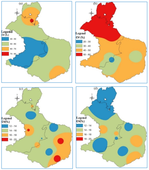
3.3. Seasonal and Annual Rainfall Variability
Figure 4 (a-d) displays the spatial distribution of the seasonal and annual coefficient of variation (CV) of rainfall across the study area, revealing a strong inverse correlation with rainfall amounts. Areas that receive lower average rainfall tend to exhibit higher CV values, indicating greater variability and less predictability in precipitation patterns. Conversely, regions with higher rainfall totals, particularly in the central and western show relatively lower CV values, reflecting more consistent and stable rainfall over time.
Across most of the study areas, the coefficient of variation (CV) for rainfall remains below 20% during both the annual and Kiremt (main rainy) seasons. This low CV value suggests that rainfall patterns during these periods are relatively stable, with minimal variability from year to year. As such, the majority of stations analyzed exhibit consistently low variance in rainfall amounts when viewed on an annual basis, as well as during the Kiremt season. However, when rainfall is examined seasonally, a different pattern emerges, with many areas experiencing moderate to high levels of variability.
This contrast is clearly illustrated in
Figure 4a and
Figure 4b which depict the spatial distribution of rainfall variability across various seasons. Notably, during the
Bega season (the dry season), the CV value exceeds 40% throughout all regions of Gojjam, as shown in
Figure 4a. This indicates a very high degree of rainfall variability during this time of year, meaning that rainfall during
Bega is not only infrequent but also highly unpredictable across the region. Similarly, the
Belg season (the short rainy season) also exhibits significant variability, with CV values surpassing 40% in nearly every part of Gojjam (
Figure 4b). This highlights a pattern of extreme fluctuations in rainfall during the transitional
Belg season, further emphasizing the seasonal inconsistency in precipitation across the study area.
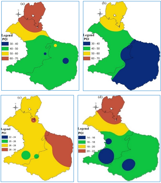
Similarly, the Precipitation Concentration Index (PCI) values reflect a heterogeneous distribution of rainfall across the seasons, further highlighting the irregularity of precipitation in the study area. Specifically, during the
Bega and
Belg seasons, the spatial distribution of PCI values exceeds 30 across the majority of western Amhara, as illustrated in
Figures 5(a) and 5(b). A PCI value greater than 30 is indicative of a highly uneven or irregular distribution of rainfall over the months within a season. This pattern suggests that rather than being spread evenly across the season, rainfall tends to occur in short, intense bursts, with long dry spells in between. Although the entire study area shows signs of uneven seasonal and annual rainfall distribution, the
Bega and
Belg seasons are particularly prone to greater variability when compared to the more stable
Kiremt season. This pronounced irregularity in precipitation patterns during
Bega and
Belg can have significant implications for both the environment and human livelihoods.
Figure 4. Spatial distribution of CV a) Bega; b) Belg; c) Kiremt and d) Annual.
A high PCI not only implies erratic rainfall but also introduces the risk of both droughts and extreme rainfall events within the same season. Such fluctuations complicate effective water resource management, making it challenging to ensure a consistent water supply for agricultural and domestic use. During these unpredictable periods, the viability of crop growth may be severely hindered, as plants and agricultural systems typically rely on more regular and predictable watering patterns. The consequences of these rainfall irregularities can be far-reaching. High precipitation concentration often leads to a dual threat: the risk of droughts, which can cause water scarcity, and the threat of floods, which can damage infrastructure and erode valuable agricultural land. These extremes directly impact food security, as well as the availability and quality of water resources. Moreover, managing these challenges becomes increasingly complex in areas with concentrated rainfall. Infrastructure such as irrigation systems and water storage facilities may not be equipped to handle sudden surges of water or prolonged dry periods. Soil erosion prevention and effective local water governance become more difficult under such conditions, as highlighted by Bogale
, underscoring the need for adaptive and resilient water management strategies in regions prone to high precipitation concentration.
Figure 5. Spatial distribution of PCI a) Bega; b) Belg; c) Kiremt and d) Annual.
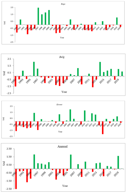
The Standardized Anomaly Index (SAI) was utilized to identify and evaluate the wettest and driest years within each rainfall season across the study area. This analytical approach enabled a detailed understanding of seasonal rainfall fluctuations over time. The results revealed that both wet and dry years occurred during the two primary rainy seasons:
Kiremt (June to September) and
Belg (February to May), highlighting the variability in precipitation patterns within the region. During the
Kiremt season, the years identified as the wettest were 1996, 2002, 2006, 2010, 2012, and 2019
(Figure 6c).
Figure 6. Seasonal and annual rainfall standardized anomalies of areal from 1991 to 2020.
These years experienced significantly higher-than-average rainfall, as reflected by positive SAI values. In contrast, the driest
Kiremt seasons were observed in the years 1991-1995, 1997, 2009, and 2015, which all recorded below-average rainfall with negative SAI values. A notable trend emerging from this analysis is the increasing frequency of extreme dry years, particularly in recent decades. This trend suggests a growing susceptibility to drier conditions across the study area, with a pronounced impact during the
Belg season compared to the
Kiremt season. This event illustrates the profound vulnerability of Ethiopia’s rain-dependent agriculture and rural livelihoods to climate variability. For instance, According to Mekonen
| [29] | Mekonen A A, Berlie A B and Ferede M B 2020 Spatial and temporal drought incidence analysis in the northeastern highlands of Ethiopia Geoenvironmental Disasters 7 1-17 https://doi.org/10.1186/s40677-020-0146-4 |
[29]
, approximately 10.2 million people across northern, eastern, and southern Ethiopia were affected by the 2015 El Niño-induced drought, which severely disrupted the country’s climate system. The failure of the two main rainy seasons
Belg and
Kiremt had catastrophic effects, as more than 80% of Ethiopia’s agricultural production and around 85% of their workforce depends on rainfall during these seasons. In response to the widespread food insecurity and water shortages triggered by the drought, the Ethiopian government and international humanitarian organizations estimated that $4.1 billion USD would be required to address the ensuing food crisis
| [30] | Kasie T A, Demissie B S, Bahry M J, Gessesse G M and Wale L E 2020 The impact of the 2015 El Niño-induced drought on household consumption: Evidence from rural Ethiopia Clim. Dev. 12 854-63. https://doi.org/10.1080/17565529.2019.1701400 |
[30]
.
3.4. Seasonal Rainfall Characteristics.
The mean onset and cessation date and length of the growing period in Gojjam for the main rainy season are shown in
Table 3. The results of the study reveal notable differences in the onset dates of the rainy season. In Gojjam sub-region, the earliest and latest onset dates for the period 1991 to 2020 were 144 DOY (24 May) and 154 DOY (3 June), respectively. The mean onset date of Gojjam was 148 DOY (28 May) for the specified study period. A study by Ayalew
| [27] | Ayalew D, Tesfaye K, Mamo G, Yitaferu B and Bayu W 2012 Variability of rainfall and its current trend in Amhara region, Ethiopia Afr. J. Agric. Res. 7 1475-86. https://doi.org/10.5897/AJAR11.698 |
[27]
reported 167 DOY (15 June) as the mean date of onset for
Kiremt rainfall in the Amhara National Regional State. Additionally,
| [31] | Wasihun G F, Mengistu M and Lisanework N CHARACTERIZATION OF PAST AND FUTURE CLIMATE VARIABILITY OF HABRO DISTRICT, WEST HARERGHE ZONE, OROMIA, ETHIOPIA 7. |
| [32] | Taye M, Zewdu F and Ayalew D 2013 Characterizing the climate system of Western Amhara, Ethiopia: a GIS approach Am. J. Res. Commun. 1 319-55. |
[31, 32]
showed that the start of the rainy season varies from place to place. This early onset is likely influenced by localized climatic and topographic factors that favor the earlier arrival of moisture-bearing systems.
Similarly, the cessation dates show comparatively high variation across the study area. During the period 1991-2020, the earliest cessation date ranged from 256 DOY (13 September) at Deber Work to 270 DOY (27 September) at Dingayber. This indicates that the start of the rainy season may fluctuate significantly from one region to another, and also the end of the season is inconsistent throughout the zone. The mean cessation date of Gojjam was 264 DOY (21 September) for the specified study period.
Furthermore,
Table 3 shows the station and regional length of the growing season for the period 1991 to 2020. The result indicated that the minimum length of the growing season ranged from 103 days (Deber Work) to 128 days (Bahir Dar). The mean length of the growing season was 120 days. These results are in line with Hadgu
| [33] | Hadgu G, Tesfaye K and Mamo G 2015 Analysis of climate change in Northern Ethiopia: implications for agricultural production Theor. Appl. Climatol. 121 733-47. https://doi.org/10.1007/s00704-014-1261-5 |
[33]
, which reported that the average length of the growing period in northern Ethiopia varies from 66 to 85 days depending on the location of the study area. Additionally, a study by Gebremicheal
| [34] | Gebremichael A, Quraishi S and Mamo G 2014 Analysis of seasonal rainfall variability for agricultural water resource management in southern region, Ethiopia J Nat Sci Res 4 56-79. |
[34]
reported that the LGP period in the Hosaina area ranges from 124 to 253 days with a mean of 193 days, CV and SD of 8% and 35 days, respectively.
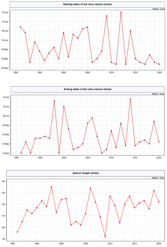
Figure 7 shows the line graph representation of the onset date, cessation date, and length of the growth period for the period 1991-2020. The graph showed that most onset date over the study area was recorded between 22 May and 19-June. The earliest onset date of the main rainy season was recorded as 142 DOY (22 May) and the late onset date of 170 DOY (19 June) during the years 2013 and 2012, respectively.
Table 3. Characterization of main rainy season rainfall.
Stations | Mean onset date (DOY) | Mean cessation date (DOY) | Length Growing period. |
Adet | 152 | 262 | 126 |
Bahir Dar | 150 | 262 | 128 |
Deber Markos | 145 | 265 | 120 |
Deber Work | 153 | 256 | 103 |
Dembecha | 146 | 267 | 121 |
Dingayber | 144 | 270 | 126 |
Feresebet | 144 | 267 | 121 |
Layber | 146 | 265 | 119 |
Motta | 147 | 262 | 115 |
Sekela | 144 | 267 | 123 |
Yetenora | 146 | 261 | 115 |
Zegie | 154 | 262 | 127 |
Similarly,
Figure 7 shows the mean cessation date of the main rainy season (
Kiremt). The mean cessation date in Gojjam varies from year to year. The earliest cessation date was recorded during 1991, 1993, 1999, and 2008. Moreover, most of the cessation dates of the main rainy season were after September 20.
The number of days between the start and end of the rainy season is also given in figure
Figure 7. The line graph depicted that, the length of the rainy season varies for the period 1991 to 2020. But for most of the study period, the season length was between 110 and 130 days. The years 2006, 1998, 2010, 2014, and 2019 have a long length of growing season. On the other hand, the years 1991, 2002, 2004, and 2009 have short length of growing season.
Figure 7. Areal onset date, cessation date and Length of growing period, respectively.
4. Conclusions
In Gojjam, there was heterogeneity in the spatial distribution of seasonal and annual rainfall. Then, mean annual rainfall ranges between 900 mm and 2100 mm, reflecting both spatial and temporal variability in precipitation. Climatologically, Gojjam experiences a unimodal rainfall pattern, with one distinct rainy season throughout the year. The main rainy season occurs from June to September (JJAS), locally referred to as Kiremt. During this period, the region receives a mean rainfall amount between 600 mm and 1600 mm, which accounts for approximately 76.3% of the total annual rainfall. This season is critical to the region's water resources, agriculture, and ecosystem health. During the Kiremt and annual rainfall periods, the coefficient of variation (CV) indicated low to moderate variability across the study area. In contrast, rainfall during the Bega and Belg seasons demonstrated significantly high variability, exceeding typical limits. The PCI data revealed exceptionally uneven distribution throughout most parts of the study area, characterized by high concentrations and fluctuations in both annual and seasonal time series. The highest PCI values were observed in the northern and northeastern sections of the study area, whereas the southern and southwestern regions recorded the lowest PCI values. Based on the Standardized Anomaly Index (SAI), Gojjam has experienced both extremely wet and dry years. The findings demonstrated that the majority of the study area had negative anomalies.
Regarding, the onset and cessation of rainfall, the average onset date for the Kiremt season across most parts of the study area ranges from 24-May to 3-June. The mean onset date of Gojjam was 148 DOY (28-May) for the specified study time period. Similarly, the cessation dates show comparatively high variation across the study area. The earliest cessation date ranged from 256 DOY (13-September) to 270 DOY (27-September). The mean cessation date of Gojjam was 264 DOY (21-September) for the specified study time period. Furthermore, the result indicated that the minimum length of growing season ranged from 103 days to 128 days.
The fluctuations in annual and seasonal rainfall from year to year indicate that climate-sensitive sectors, such as agriculture (including both crops and livestock) and water resource management, are already significantly vulnerable to current climate-related challenges. As a result, this study suggests that addressing the issues arising from rainfall variability in the region requires the enhancement of localized climate advisory services that can provide real-time and accurate weather and seasonal rainfall forecasts. Improving water conservation techniques, such as rainwater harvesting systems and terracing, along with implementing supplemental and deficit irrigation methods, can help reduce reliance on unpredictable rainfall.