1. Introduction
Forest canopy gaps are fundamental structural features that drive ecological processes in forest ecosystems
| [1] | Brokaw, N. V. L. Gap-phase regeneration in a tropical forest. Ecology. 1985, 66(3), 682-687.
https://doi.org/10.2307/1940529 |
| [2] | Runkle, J. R. Gap regeneration in some old-growth forests of the eastern United States. Ecology. 1981, 62(4), 1041-1051. |
| [3] | Tian, A et al. Research history of forest gap as small-scale disturbances in forest ecosystems. Forests. 2024, 15(1), 21. https://doi.org/10.3390/f15010021 |
[1-3]
. These openings in the forest canopy, created by tree falls, branch falls, bole snap or other disturbances, serve as critical sites for forest regeneration, species recruitment, and biodiversity maintenance
| [3] | Tian, A et al. Research history of forest gap as small-scale disturbances in forest ecosystems. Forests. 2024, 15(1), 21. https://doi.org/10.3390/f15010021 |
| [4] | Whitmore, T. C. Canopy gaps and the two major groups of forest trees. Ecology. 1989, 70(3), 536-538. |
| [5] | Denslow, J. S. Tropical rainforest gaps and tree species diversity. Annual Review of Ecology and Systematics. 1987, 18(1), 431-451. |
[3-5]
. Forest gap dynamics have been extensively studied since pioneering work in the 1940s, 1980s till date, which established gaps as fundamental units of forest structure
. The size, frequency, and distribution of canopy gaps significantly influence forest composition, age structure, and successional trajectories
| [3] | Tian, A et al. Research history of forest gap as small-scale disturbances in forest ecosystems. Forests. 2024, 15(1), 21. https://doi.org/10.3390/f15010021 |
| [6] | Schnitzer, S. A., Carson, W. P. Treefall gaps and the maintenance of species diversity in a tropical forest. Ecology. 2001, 82(4), 913-919. |
[3, 6]
.
Recent studies have further emphasized the critical role of canopy gaps in maintaining forest resilience under changing environmental conditions. Slik et al. (2018) demonstrated that gap dynamics are accelerating in tropical forests globally, with significant implications for carbon cycling and biodiversity conservation. Dalagnol et al. (2019) utilized advanced remote sensing techniques to show that gap formation rates have increased by 23% in Amazonian forests over the past two decades, potentially linked to more frequent extreme weather events associated with climate change. Furthermore, Yang et al. (2023) found that gap characteristics, particularly size distribution, are crucial determinants of forest recovery trajectories following disturbances, with larger gaps (60-120 m²) showing optimal conditions for native species regeneration.
1.1. Gap Measurement Methods and Classification
Brokaw (1982) provided one of the first comprehensive frameworks for gap definition and measurement, establishing protocols that remain widely used in tropical forest research. His classification system, categorizing gaps by area into small (<100 m²), medium (100-400 m
2), and large (>400 m
2) classes, has become a standard in gap ecology studies
. Multiple methodologies have been developed for gap area estimation, each with specific advantages and limitations. The Grid-Quadrat method, involving overlay of standardized grid cells, offers high precision but can be time-intensive in the field
| [2] | Runkle, J. R. Gap regeneration in some old-growth forests of the eastern United States. Ecology. 1981, 62(4), 1041-1051. |
[2]
. The Ellipse Approximation method, treating irregular gaps as ellipses defined by major and minor axes, provides faster measurements while maintaining acceptable accuracy for most ecological applications
. Comparative studies have shown that method selection should consider trade-offs between precision requirements, field time constraints, and gap shape characteristics
| [12] | Lertzman, K. P., Sutherland, G. D., Inselberg, A., and Saunders, S. C. Canopy gaps and the landscape mosaic in a coastal temperate rain forest. Ecology. 1996, 77(4), 1254-1270. |
[12]
.
Accurate measurement and classification of forest gaps remain essential for understanding forest dynamics, predicting regeneration patterns, and implementing sustainable forest management practices
| [13] | Runkle, J. R. Guidelines and sample protocol for sampling forest gaps. General Technical Report PNW-GTR-283. Portland, OR: U.S. Department of Agriculture, Forest Service, Pacific Northwest Research Station; 1992, 44 p. |
[13]
. Traditional gap assessment methodologies, while scientifically robust, often present practical challenges in field implementation, particularly in remote tropical forest locations where infrastructure limitations and environmental conditions complicate data collection and processing
. Contemporary research has highlighted additional challenges in gap assessment. Asner et al. (2013) noted that traditional ground-based methods often underestimate gap frequency due to sampling limitations, while Terryn et al. (2024) reported that manual data collection in tropical forests can result in error rates <= 15% due to difficult field conditions and transcription mistakes. Moreover, Aubry-Kientz et al. (2013) emphasized the need for standardized, repeatable measurement protocols to enable meaningful comparisons across forest types and geographic regions, a requirement that traditional paper-based methods struggle to meet consistently.
1.2. Digital Technologies in Forest Research
The advent of digital technologies offers unprecedented opportunities to enhance field ecology research through improved data quality, real-time analysis, and seamless integration between field collection and laboratory processing
. The integration of digital technologies into forestry has evolved from simple data loggers to sophisticated integrated systems combining remote sensing, geographic information systems, and mobile computing
| [18] | Guo, Q., Su, Y., Hu, T., and Wang, X. An integrated UAV-borne lidar system for 3D habitat mapping in three forest ecosystems across China. International Journal of Remote Sensing. 2017, 38(8-10), 1-19. |
[18]
. Early applications focused on tree mapping and clinometer systems for growth monitoring
| [19] | Luoma, V. et al. Assessing precision in conventional field measurements of individual tree attributes. Forests. 2017, 8(2), 38. https://doi.org/10.3390/f8020038 |
[19]
. Recent developments include drone-based canopy assessment, LiDAR gap detection, and automated image analysis systems
| [20] | Wallace, L., Lucieer, A., Malenovský, Z., Turner, D., and Vopěnka, P. Assessment of forest structure using two UAV techniques: A comparison of airborne laser scanning and structure from motion (SfM) point clouds. Forests. 2016, 7(3), 62. https://doi.org/10.3390/f7030062 |
[20]
. However, existing digital forestry tools often require continuous internet connectivity, specialized hardware, or complex installation procedures that limit their utility in remote field sites
. These advanced technologies often require substantial investment, specialized training, and controlled conditions limiting field applicability
| [22] | Hyyppä, E. et al. Comparison of backpack, handheld, under-canopy UAV, and above-canopy UAV laser scanning for field reference data collection in boreal forests. Remote Sensing. 2020, 12(20), 1-31. https://doi.org/10.3390/rs12203327 |
[22]
.
Studies have identified a persistent need for practical, accessible tools that bridge traditional field methods and digital data management
. Recent technological advances have begun addressing some of these limitations, though significant gaps remain. Howard et al. (2022) reviewed mobile applications for biodiversity research and found that while smartphone-based tools are proliferating, most lack robust offline functionality essential for remote fieldwork. The potential of Progressive Web Applications for environmental monitoring has been demonstrated, particularly due to their cross-platform compatibility and ability to function offline, although ecology-focused implementations remain limited
| [24] | Batsaikhan, A., Hachinger, S., Kurtz, W., Heller, H., and Frank, A. Application of modern web technologies to the citizen science project BAYSICS on climate research and science communication. Sustainability. 2020, 12(18), 7748.
https://doi.org/10.3390/su12187748 |
[24]
. Digital tools can transform ecological survey practices, though little work has been carried out in this domain
. There is critical need for low-cost, accessible digital tools capable of operating independently of internet infrastructure, particularly for ecological surveys in biodiversity hotspots located in developing countries where connectivity is often unreliable or totally absent
.
1.3. Progressive Web Applications and Data Management
Progressive Web Applications represent an emerging paradigm in scientific computing, offering native app-like experiences through web technologies
| [27] | Biørn-Hansen, A., Majchrzak, T. A., and Grønli, T. M. Progressive web apps: The possible web-native unifier for mobile development. In Proceedings of the 13th International Conference on Web Information Systems and Technologies (WEBIST). Porto, Portugal, 2017; pp. 344-351. |
| [28] | Klimenchenko, E., Goncharov, V., Sidorov, D., and Dudak, A. Progressive Web Application Development Technologies: Analyzing and Evaluating Effectiveness. Vestnik komp'iuternykh i informatsionnykh tekhnologii. 2025, (3), 3-11.
https://doi.org/10.14489/vkit.2025.03.pp.003-011 |
[27, 28]
. PWAs provide several advantages for field research: offline functionality through service workers, cross-platform compatibility without separate development, and immediate updates without user intervention
| [29] | Tandel, S. S., Jamadar, A. Impact of progressive web apps on web app development. International Journal of Innovative Research in Science, Engineering and Technology. 2018, 7(9), 9439-9444. |
| [30] | Josephe, A. O. et al. Progressive web apps to support (critical) systems in low or no connectivity areas. In Proceedings of the 2023 IEEE IAS Global Conference on Emerging Technologies (GlobConET). London, UK, 2023; pp. 1-6.
https://doi.org/10.1109/GlobConET56651.2023.10150058 |
[29, 30]
. Recent applications of PWA technology in scientific contexts include biodiversity surveys, geological field mapping, and ecological monitoring
| [31] | Kamilaris, A., and Prenafeta-Boldú, F. X. A review of the use of convolutional neural networks in agriculture. The Journal of Agricultural Science. 2018, 156, 312-322. |
| [32] | Green, S. E., Rees, J. P., Stephens, P. A., Hill, R. A., and Giordano, A. J. Innovations in camera trapping technology and approaches: The integration of citizen science and artificial intelligence. Animals. 2020, 10(1), 132.
https://doi.org/10.3390/ani10010132 |
[31, 32]
. These implementations demonstrate PWA viability for data-intensive field research while highlighting the importance of offline-first design, data validation, and export protocols
| [23] | Howard, L., van Rees, C. B., Dahlquist, Z., Luikart, G., and Hand, B. K. A review of invasive species reporting apps for citizen science and opportunities for innovation. NeoBiota. 2022, 71, 165-188.
https://doi.org/10.3897/neobiota.71.79597 |
| [30] | Josephe, A. O. et al. Progressive web apps to support (critical) systems in low or no connectivity areas. In Proceedings of the 2023 IEEE IAS Global Conference on Emerging Technologies (GlobConET). London, UK, 2023; pp. 1-6.
https://doi.org/10.1109/GlobConET56651.2023.10150058 |
[23, 30]
.
Effective data management remains a critical challenge in field surveys, where conditions often compromise data integrity through transcription errors, physical damage to field notebooks, or loss of data sheets
| [33] | Michener, W. K. Ecological data sharing. Ecological Informatics. 2015, 29, 33-44. |
[33]
. Digital data collection systems have shown significant improvements in data quality, with studies reporting error rate reductions between 10-40% compared to paper-based methods
| [34] | Mukasa, O., Mushi, H. P., Maire, N., Ross, A., and de Savigny, D. Do surveys with paper and electronic devices differ in quality and cost? Experience from the Rufiji Health and demographic surveillance system in Tanzania. Global Health Action. 2017, 10(1), 1387984.
https://doi.org/10.1080/16549716.2017.1387984 |
| [35] | Tate, A., Smallwood, C. Comparing the efficiency of paper-based and electronic data capture during face-to-face interviews. PLOS ONE. 2021, 16(3), e0247570.
https://doi.org/10.1371/journal.pone.0247570 |
[34, 35]
. Key requirements for ecological data management systems include: structured data entry with validation, immediate error detection, redundant data storage, standardized export formats, and audit trails for data provenance
| [36] | Reichman, O. J., Jones, M. B., and Schildhauer, M. P. Challenges and opportunities of open data in ecology. Science. 2011, 331(6018), 703-705. |
[36]
. The integration of these principles into field-deployable applications represents an ongoing challenge in ecological informatics.
1.4. Research Gap and Objectives
Despite the proliferation of mobile applications in ecological research, a significant gap exists in accessible, offline-capable tools specifically designed for forest gap assessment. Current solutions either lack scientific rigor in measurement protocols, require expensive proprietary software, or fail to function in offline field conditions where cellular and internet connectivity are unavailable.
This study addresses this gap by developing and validating a Progressive Web Application (PWA) that:
1) Implements scientifically validated gap measurement methodologies,
2) Operates fully offline in remote field locations,
3) Provides immediate gap classification using established ecological frameworks,
4) Ensures data integrity through structured validation and export protocols,
5) Functions across multiple platforms without installation requirements,
6) Facilitates seamless data transfer between field and laboratory environments.
1.5. Significance and Novelty
This research contributes to the growing field of forest informatics by presenting a novel integration of information technologies with forest ecology protocols. The application's significance lies in its practical approach to solving real-world fieldwork challenges while maintaining scientific rigor. Unlike previous digital forestry tools, this system prioritizes:
1) Accessibility: No specialized hardware or expensive licenses required,
2) Reliability: Full offline functionality with automatic data preservation,
3) Validity: Implementation of established scientific measurement protocols,
4) Portability: Cross-platform compatibility and standard data formats,
5) Extensibility: Open architecture allowing protocol customization.
This study advances United Nations Sustainable Development Goals (SDG) 15 by delivering an offline-capable, scientifically validated forest gap assessment PWA, ensuring ecological rigor, cross-platform accessibility, seamless data transfer, and resilient innovation supporting sustainable forest management and climate action.
2. Materials and Methods
The methodology integrates comprehensive requirements analysis, modern web architecture design, and rigorous field validation. Development encompassed implementation of standardized gap measurement protocols, automated classification systems, and offline-capable data management. Validation involved statistical comparison of the Ellipse and Grid-Quadrat measurement methods using 303 paired observations at Korup National Park and quantitative evaluation of application performance against established benchmarks and traditional paper-based workflows.
2.1. System Requirements Analysis
The development process began with comprehensive requirements analysis based on:
1) Literature review of forest informatics methodologies and measurement protocols,
2) Field surveys at Korup National Parks to identify workflow pain points,
3) Technical assessment of infrastructure constraints in tropical forest field sites,
4) Comparative analysis of 2 gap measurement methods.
Key functional requirements identified included:
1) Implementation of 2 gap measurement methods,
2) Automated classification systems,
3) Offline operation capabilities,
4) Data export in standard formats,
5) Multi-device compatibility,
6) Intuitive user interface requiring minimal training.
2.2. Application Architecture
The application employs a modern, offline-first web architecture designed for reliability in field conditions. Built with vanilla JavaScript and browser LocalStorage, it features modular design, service worker-based offline capability, and a structured data model ensuring consistency and reproducibility. This technology stack prioritizes stability and broad compatibility over framework-dependent features.
2.2.1. Technology Stack
The application employs a modern web technology stack optimized for offline-first operation:
1) Frontend Framework: Vanilla JavaScript with modular architecture,
2) Data Persistence: Browser LocalStorage Application Programming Interface (API) with fallback mechanisms,
3) Service Workers: Custom implementation for offline caching and background synchronization,
4) Styling: Cascading Style Sheets (CSS) 3 with responsive design principles,
5) Data Export: Client-side Comma Separated Values (CSV) generation,
6) Progressive Enhancement: Feature detection ensuring baseline functionality across browsers.
This technology selection prioritizes reliability, performance, and broad compatibility over framework-dependent features that might compromise stability in field conditions.
2.2.2. Application Structure
The system implements a modular architecture with clear separation of concerns:
Core Modules
1) Calculations Engine (calculations.js)
2) User Interface Controller (ui.js)
3) Application State Manager (app.js)
Data Layer
1) LocalStorage Manager
2) CSV Parser/Generator
3) Data Validation Engine
Offline Infrastructure
1) Service Worker
2) Cache Management
3) Background Sync Handler
User Interface
1) Data Entry Forms
2) Results Display
3) Modal Dialogs
2.2.3. Data Model
The application employs a robust and structured data model to ensure data consistency, integrity, and ease of downstream analysis. Each gap record is stored as a self-contained object with the following fields:
javascript
id: Integer // Unique record identifier
plotNumber: String // Plot/cluster designation
gapNumber: String // Gap identifier within plot
speciesInvolved: String // Causal species (optional)
causalFactor: Enumerated // Disturbance type
method: Enumerated // Measurement method
area: Float // Calculated area (m2)
classification: Enumerated // Brokaw's classification
calculationInputs: Object // Method-specific parameters
}
This model supports key application features, including automatic area recalculation and reclassification upon input edits, seamless data export to CSV, and long-term data integrity during offline storage. The inclusion of method-specific inputs in calculationInputs enables full reproducibility of calculations, facilitates validation against field notes, and allows for potential future extensions (e.g., uncertainty estimates or alternative formulas). All fields are validated client-side to prevent invalid entries, contributing to the observed elimination of transcription and classification errors in field testing.
2.3. Implementing Gap Measurement Methods
The application implements two standardized protocols for quantifying canopy gap areas: the Grid-Quadrat method and the Ellipse Approximation method.
2.3.1. Grid-Quadrat Method
The Grid-Quadrat implementation follows established protocols for measuring forest gap sizes through systematic sampling. In this method, a predetermined grid of uniform squares is overlaid across the study area, and gap size is calculated based on the number of grid cells that fall within the gap boundary
. This approach involves establishing a grid framework with fixed cell dimensions (commonly 1 m × 1 m, 2 m × 2 m, or 5 m × 5 m depending on expected gap sizes and desired precision) across the forest plot
| [11] | Yamamoto, S. I. Forest gap dynamics and tree regeneration. Journal of Forest Research. 2000, 5, 223-229.
http://dx.doi.org/10.1007/BF02767114 |
| [13] | Runkle, J. R. Guidelines and sample protocol for sampling forest gaps. General Technical Report PNW-GTR-283. Portland, OR: U.S. Department of Agriculture, Forest Service, Pacific Northwest Research Station; 1992, 44 p. |
[11, 13]
. When a gap is encountered, researchers count all grid squares that fall wholly or partially within the gap perimeter, defined by the crowns of surrounding canopy trees, and multiply this count by the area of an individual grid cell to obtain total gap size
| [39] | Fehmi, J. S., and Bartolome, J. W. A grid-based method for sampling and analysing spatially ambiguous plants. Journal of Vegetation Science. 2001, 12(4), 467-472. |
[39]
.
For grid cells that are only partially within the gap, researchers may either include them if more than 50% falls within the gap boundary, exclude them if less than 50% is covered, or estimate the proportion of each edge cell that lies within the gap for more precise calculations
| [1] | Brokaw, N. V. L. Gap-phase regeneration in a tropical forest. Ecology. 1985, 66(3), 682-687.
https://doi.org/10.2307/1940529 |
| [39] | Fehmi, J. S., and Bartolome, J. W. A grid-based method for sampling and analysing spatially ambiguous plants. Journal of Vegetation Science. 2001, 12(4), 467-472. |
[1, 39]
. This grid-counting method provides a standardized, reproducible approach to gap size measurement that minimizes the subjectivity associated with measuring irregular gap shapes, while maintaining sufficient accuracy for ecological analyses of gap dynamics
| [11] | Yamamoto, S. I. Forest gap dynamics and tree regeneration. Journal of Forest Research. 2000, 5, 223-229.
http://dx.doi.org/10.1007/BF02767114 |
| [40] | Denslow, J. S., and Hartshorn, G. S. Tree-fall gap environments and forest dynamic processes. In La Selva: Ecology and Natural History of a Neotropical Rain Forest, McDade, L. A., Bawa, K. S., Hespenheide, H. A., and Hartshorn, G. S., Eds. Chicago: University of Chicago Press; 1994, pp. 120-127. |
[11, 40]
. The method is particularly efficient for large-scale gap surveys and facilitates comparison of gap size distributions across different forest types and study sites
| [13] | Runkle, J. R. Guidelines and sample protocol for sampling forest gaps. General Technical Report PNW-GTR-283. Portland, OR: U.S. Department of Agriculture, Forest Service, Pacific Northwest Research Station; 1992, 44 p. |
| [41] | Hubbell, S. P. et al. Light-gap disturbances, recruitment limitation, and tree diversity in a neotropical forest. Science. 1999, 283(5401), 554-557. |
[13, 41]
.
Algorithm:
Gap area is determined using the formula:
Area = n × A
where:
n = number of grid squares covering gap
A = area of single grid square (m2)
Implementation considerations:
1) Input validation ensuring positive integer values for square count,
2) Configurable square size to accommodate different research protocols,
3) Automatic area calculation with precision to 0.01 m2,
4) Storage of original measurement parameters for audit trail.
2.3.2. Ellipse Approximation Method
The Ellipse Approximation follows Yamamoto (2000) and treats irregular forest gap shapes as ellipses for standardized measurement. This method simplifies gap size quantification by measuring two perpendicular radii of the canopy opening
| [1] | Brokaw, N. V. L. Gap-phase regeneration in a tropical forest. Ecology. 1985, 66(3), 682-687.
https://doi.org/10.2307/1940529 |
| [2] | Runkle, J. R. Gap regeneration in some old-growth forests of the eastern United States. Ecology. 1981, 62(4), 1041-1051. |
[1, 2]
. The measurement protocol involves first identifying the longest axis of the gap by measuring the maximum linear distance across the canopy opening from edge to edge
| [2] | Runkle, J. R. Gap regeneration in some old-growth forests of the eastern United States. Ecology. 1981, 62(4), 1041-1051. |
| [42] | van der Meer, P. J., Dignan, P., and Saveneh, A. G. Effect of gap size on seedling establishment, growth and survival at three years in mountain ash (Eucalyptus regnans F. Muell.) forest in Victoria, Australia. Forest Ecology and Management. 1999, 117(1-3), 33-42. https://doi.org/10.1016/S0378-1127(98)00471-X |
[2, 42]
. Half of this measurement yields the long radius (r
2). The short radius (r
1) is then determined by measuring the perpendicular axis at its widest point and dividing by two
| [6] | Schnitzer, S. A., Carson, W. P. Treefall gaps and the maintenance of species diversity in a tropical forest. Ecology. 2001, 82(4), 913-919. |
| [10] | Brokaw, N. V. L. The definition of treefall gap and its effect on measures of forest dynamics. Biotropica. 1982, 14(2), 158-160. https://doi.org/10.2307/2387750 |
| [43] | Egbe, E. A., Chuyong, G. B., Fonge, B. A., and Namuene, K. S. Forest disturbance and natural regeneration in an African rainforest at Korup National Park, Cameroon. International Journal of Biodiversity and Conservation. 2012, 4, 377-384. |
[6, 10, 43]
. The validation constraint (r
2 > r
1) ensures proper orientation of the ellipse, with the long radius always representing the major semi-axis and the short radius representing the minor semi-axis
| [2] | Runkle, J. R. Gap regeneration in some old-growth forests of the eastern United States. Ecology. 1981, 62(4), 1041-1051. |
| [43] | Egbe, E. A., Chuyong, G. B., Fonge, B. A., and Namuene, K. S. Forest disturbance and natural regeneration in an African rainforest at Korup National Park, Cameroon. International Journal of Biodiversity and Conservation. 2012, 4, 377-384. |
[2, 43]
.
Gap boundaries are typically defined by the vertical projection of the crowns of surrounding canopy trees onto the forest floor, and measurements are taken from the gap center to the perimeter along each axis
| [4] | Whitmore, T. C. Canopy gaps and the two major groups of forest trees. Ecology. 1989, 70(3), 536-538. |
| [40] | Denslow, J. S., and Hartshorn, G. S. Tree-fall gap environments and forest dynamic processes. In La Selva: Ecology and Natural History of a Neotropical Rain Forest, McDade, L. A., Bawa, K. S., Hespenheide, H. A., and Hartshorn, G. S., Eds. Chicago: University of Chicago Press; 1994, pp. 120-127. |
[4, 40]
. This geometric approximation method provides a practical balance between measurement precision and field efficiency, particularly in dense forest environments where complex gap geometries are challenging to map in detail
. The ellipse approximation has been validated against more intensive digitized boundary mapping techniques and shows strong correlations with actual gap areas, especially for gaps between 50 and 500 m
2 | [13] | Runkle, J. R. Guidelines and sample protocol for sampling forest gaps. General Technical Report PNW-GTR-283. Portland, OR: U.S. Department of Agriculture, Forest Service, Pacific Northwest Research Station; 1992, 44 p. |
| [41] | Hubbell, S. P. et al. Light-gap disturbances, recruitment limitation, and tree diversity in a neotropical forest. Science. 1999, 283(5401), 554-557. |
[13, 41]
. The method requires only basic equipment measuring tapes and a compass for orientation data, making it suitable for remote field locations and enabling rapid assessment of multiple gaps for robust statistical analyses
| [45] | Canham, C. D. et al. Light regimes beneath closed canopies and tree-fall gaps in temperate and tropical forests. Canadian Journal of Forest Research. 1990, 20(5), 620-631.
https://doi.org/10.1139/x90-084 |
| [46] | Gray, A. N., and Spies, T. A. Gap size, within-gap position and canopy structure effects on conifer seedling establishment. Journal of Ecology. 1996, 84(5), 635-645.
https://doi.org/10.2307/2261327 |
[45, 46]
.
Algorithm:
Gap area is determined using the standard ellipse formula:
Area = π × r1 × r2
where:
r1 = short radius (m)
r2 = long radius (m)
r2 > r1 (validation constraint)
Implementation considerations:
1) Constraint validation ensuring r2 > r1,
2) Real-time calculation preview during data entry,
3) Parameter storage for result reproducibility.
2.4. Classification System Implementation
The application implements Brokaw's (1982) canopy gap classification system, which categorizes gaps based on their projected ground area as small (<100 m2), medium (100-400 m2), or large (>400 m2). This categorization is fully automated within the PWA using the following logic:
javascript
function brokawClassification(area) {
if (area < 100) return "Small gap";
else if (area <= 400) return "Medium gap";
else return "Large gap";
}
Classification is triggered instantly upon completion of area calculation, whether via the ellipse approximation or grid-quadrat method, providing immediate on-screen visual feedback (e.g., color-coded labels and icons) to support real-time field decision-making. The system ensures consistency by automatically re-evaluating and updating the classification whenever underlying measurement parameters (radii, grid counts, or square size) are edited, preventing discrepancies between recorded measurements and assigned categories. This eliminates manual classification errors observed in traditional paper-based workflows and enhances data reliability throughout the collection and editing process.
2.5. Hosting, Offline Functionality and Data Persistence
The Progressive Web Application (PWA) is hosted on a cloud-based deployment platform that ensures reliable availability and scalable performance. The application is publicly accessible via the following URL: https://gap-dynamics-app.onrender.com. This hosting configuration supports continuous deployment, and seamless access across desktop and mobile devices. By leveraging a web-based hosting environment, the application can be easily accessed by researchers in the field without requiring platform-specific installation, while still supporting Progressive Web App features such as offline use and home-screen installation.
2.5.1. Service Worker Implementation
The Progressive Web Application's offline capabilities are powered by a dedicated service worker that implements a robust cache-first network strategy, ensuring seamless functionality in areas with unreliable or absent connectivity, common in remote tropical forest research sites. The core fetch handler is configured as follows:
javascript
self.addEventListener('fetch', event => {
event.respondWith(
caches.match(event.request)
.then(response => response || fetch(event.request))
);
});
This implementation employs a cache-first approach for all application resources, delivering instantaneous load times during offline sessions. Critical assets precached during the install phase include:
1) Core application code Hypertext Markup Language (HTML), CSS, JavaScript),
2) User interface assets (icons, images, fonts),
3) Embedded documentation and help content (methodology guides, field protocols),
4) PWA manifest and offline fallback page.
Dynamic data (user-entered gap records) are managed separately, ensuring persistence across sessions without relying on network requests. Upon connectivity restoration, the service worker allows background synchronization if extended (e.g., for future cloud backup features), while cached static resources are updated efficiently during the activate phase through cache versioning. This architecture resulted in a minimal offline cache size of 2.4 MB and enabled full core functionality including data entry, area calculations, classification, and export during extended offline validation testing, confirming its reliability for multi-day field expeditions in remote locations.
2.5.2. Data Persistence Strategy
User data persists through multiple layers designed to ensure data security, accessibility, and portability in challenging field conditions. This multi-tiered architecture provides redundancy protecting against single points of failure, device independence supporting varied field conditions, and seamless integration with analysis pipelines. The approach balances automatic browser storage convenience with robust exportable backups, ensuring hard-won field data remains secure and accessible throughout the research lifecycle while supporting FAIR data principles and open science requirements. The application leverages the browser's LocalStorage API as the primary persistence mechanism, providing instant data access without network connectivity. LocalStorage retains data even after browser closure and device restarts, protecting against accidental loss from battery depletion or unexpected shutdowns common in fieldwork. Modern browsers provide 5-10 MB capacity, sufficient for thousands of gap measurements. Changes synchronize automatically, eliminating manual save operations and reducing data loss risk.
The CSV export functionality serves multiple critical purposes. CSV format ensures universal compatibility with spreadsheet applications (Excel, Google Sheets), statistical software (R, Python, SPSS), and database systems. As a plain-text format, CSV files remain accessible regardless of software evolution, meeting long-term archival requirements. Exported files include location metadata and complete calculation parameters, ensuring data provenance and reproducibility. Researchers can create incremental backups throughout field sessions, protecting against device failure or loss. Previously exported CSV files can be imported with complete fidelity, restoring all measurements and classifications. This enables workflow continuity across devices, enabling researchers to begin collection on one device and continue on another. The system offers additive import (appending to existing data) and replace import (loading new datasets), supporting flexible workflows. Import validation ensures data integrity, while preview functionality allows verification before integration.
2.6. Data Import, Export and Interoperability
The export mechanism generates CSV files following RFC 4180 specifications, ensuring compatibility with standard analysis tools, and maintaining data integrity across platforms. This comprehensive export format supports the complete research data lifecycle from field collection through analysis, publication, and archival deposition, while maintaining compatibility with existing research infrastructure and analytical workflows:
Location: MCNP
ID: 1
Plot/ACA/Cluster: 4
Gap: P01
Species: Tali
Causal Factor: Tree fal
Method: Grid-Quadrat
Area (m2): 156.00
Classification: Medium gap
This format facilitates direct import into statistical software (R, Python, Minitab) and spreadsheet applications (Excel, Numbers).
The import mechanism enables seamless re-integration of previously exported CSV files, supporting workflow continuity and collaborative research. The parser strictly adheres to Request for Comments (RFC) 4180 specifications while implementing intelligent data reconstruction algorithms to restore complete measurement context from standardized export formats. The system performs comprehensive file validation including:
1) Format Verification: Confirms CSV structure matches expected schema with required columns (ID, Plot, Gap, Species, Causal Factor, Method, Area, Classification),
2) Data Type Validation: Ensures numerical fields contain valid numbers and enumerated fields match acceptable values,
3) Integrity Checks: Validates that area calculations align with classification assignments and method-specific parameters,
4) Header Parsing: Extracts location metadata from file headers for automatic population of location fields.
Since CSV exports contain calculated results but not original measurement inputs (grid square dimensions, ellipse radii), the import parser employs intelligent reconstruction algorithms:
1) Grid-Quadrat Method: Estimates probable square dimensions assuming standard grid sizes (e.g., 4 m2 squares), calculating approximate side lengths,
2) Ellipse Approximation: Derives plausible major and minor radii from total area using ellipse geometry, maintaining mathematical consistency.
The system supports two import strategies:
1) Additive Import: Appends imported records to existing data, preserving current measurements while integrating new entries, ideal for combining data from multiple field sessions or team members,
2) Replace Import: Clears current dataset and loads imported records exclusively suitable for switching between research sites or projects.
Before finalizing import, users receive a comprehensive preview displaying:
1) Source filename and location identifier,
2) Number of records to be imported,
3) Sample data showing first few entries,
4) Warning if existing data will be affected.
This import capability ensures data portability across devices and sessions, supports collaborative workflows through data aggregation, and maintains compatibility with external editing in spreadsheet applications, enabling researchers to correct errors or add annotations in familiar tools before re-importing into the application.
2.7. User Interface Design
The interface design prioritizes field usability through:
1) Progressive Disclosure: Complex features hidden until prerequisite data entered,
2) Input Validation: Real-time feedback preventing invalid entries,
3) Visual Hierarchy: Clear distinction between data entry, calculation, and results,
4) Error Prevention: Confirmation dialogs for destructive actions,
5) Accessibility: High-contrast colors, large touch targets for field conditions.
2.8. Quality Assurance and Testing
Comprehensive testing ensured reliability across usage scenarios:
1) Unit Testing: Individual calculation functions validated against known values,
2) Integration Testing: Data flow between modules verified,
3) Offline Testing: Functionality confirmed without network connectivity,
4) Cross-Browser Testing: Validation on Chrome, Firefox, Safari, Edge,
5) Field Testing: Real-world validation in tropical forest conditions.
2.9. Validation of Area Estimation Methods
To validate the accuracy and agreement between the ellipse method and the grid-quadrat method for estimating gap areas, data from forest canopy gaps at Korup National Park was used. A comparative analysis was performed on 303 paired measurements obtained from the same set of gaps. Prior to comparative statistical analyses, the distributional properties of gap area estimates obtained using the ellipse approximation and grid-quadrat methods were formally assessed. Descriptive statistics, including mean, median, standard deviation, skewness, and kurtosis, were first computed for each dataset to characterize central tendency, dispersion, and distribution shape. All statistical analyses were conducted in R software
| [47] | R Core Team. R: A language and environment for statistical computing. R Foundation for Statistical Computing. Available from: https://www.R-project.org/ (accessed 1 January 2026). |
[47]
.
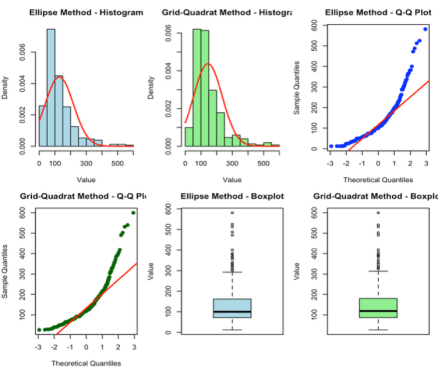
Normality was then evaluated using multiple complementary statistical tests. The Shapiro-Wilk test was applied as the primary test due to its strong performance for continuous data across a wide range of sample sizes. To further confirm robustness of the findings, the Anderson-Darling test was used to assess deviations in the tails of the distributions, while the Kolmogorov-Smirnov test (with parameters estimated from the sample mean and standard deviation) and the Lilliefors test were employed as additional distribution-free checks. Graphical diagnostics were also used to visually assess normality, including histograms with overlaid normal density curves, normal Q-Q plots, and boxplots. These visualizations complemented the formal tests by highlighting skewness, tail behavior, and potential outliers.
The combined use of descriptive statistics, multiple formal normality tests, and graphical diagnostics ensured a rigorous evaluation of distributional assumptions and informed the subsequent choice of non-parametric or distribution-free analytical approaches. Agreement between the two methods was evaluated using the Bland-Altman method
| [48] | Bland, J. M., and Altman, D. G. Statistical methods for assessing agreement between two methods of clinical measurement. The Lancet. 1986, 327(8476), 307-310.
https://doi.org/10.1016/S0140-6736(86)90837-8 |
| [49] | Bland, J. M., and Altman, D. G. Measuring agreement in method comparison studies. Statistical Methods in Medical Research. 1999, 8(2), 135-160.
https://doi.org/10.1177/096228029900800204 |
[48, 49]
, which quantifies systematic bias (mean difference) and random variation (limits of agreement and standard deviation of differences). The mean absolute difference (MAD) was also calculated as a measure of average unsigned discrepancy per gap. Total estimated areas from each method were summed and compared to compute the relative percentage difference. Linear relationship between the methods was assessed using the Spearman correlation coefficient (r) to evaluate the strength and direction of the proportional relationship between paired measurements
| [50] | Cohen, J. Statistical power analysis for the behavioral sciences. 2nd Edition. Hillsdale, NJ: Lawrence Erlbaum Associates; 1988. https://utstat.toronto.edu/~brunner/oldclass/378f16/readings/CohenPower.pdf |
| [51] | Mukaka, M. M. Statistics corner: A guide to appropriate use of correlation coefficient in medical research. Malawi Medical Journal (MMJ). 2012, 24(3), 69-71. |
| [52] | Keskin, B., and Aktas, A. Statistical power analysis. In Proceedings of the 7th International Days of Statistics and Economics. Prague, Czech Republic, 2013; pp. 578-587. |
[50-52]
.
To compare gap area estimates derived from the ellipse approximation and grid-quadrat methods, a paired-sample analytical framework was adopted, reflecting that both measurements were obtained from the same set of sampling units at Korup National Park where 303 gaps were sampled. Descriptive statistics (mean, median, and standard deviation) were first calculated for each method, as well as for the paired differences, to summarize central tendency and variability. The assumption of normality of paired differences, required for parametric testing, was formally evaluated using the Shapiro-Wilk test. Given the strong deviation from normality observed in the distribution of differences (p < 0.05), a non-parametric approach was deemed more appropriate.
Consequently, the Wilcoxon signed-rank test was selected as the primary inferential test to assess whether a systematic difference existed between the two methods. In addition to hypothesis testing, effect size was quantified using Cohen’s d
for paired samples, calculated as the mean of the paired differences divided by their standard deviation, to assess the magnitude of the observed difference independent of sample size. Graphical diagnostics, including histograms, Q-Q plots, boxplots of differences, and scatter plots with an identity line, were used to visually examine distributional properties, outliers, and agreement between methods. This combined analytical strategy ensured a robust and transparent comparison of the two measurement approaches.
2.10. Evaluation of the Digital Progressive Web Application (PWA)
Quantitative comparisons were conducted to evaluate the performance of the digital Progressive Web Application (PWA) against traditional paper-based methods for field data collection. Performance testing was conducted to evaluate suitability for field deployment, measuring key metrics such as load time, offline cache size, calculation response time, data export duration, and battery impact. These were compared against established benchmarks from Google, Android Developer Guidelines, and the Google’s Response Animation Idle Load (RAIL) model
| [53] | Google. Measure performance with the RAIL model. Google Web Fundamentals. Available from:
https://web.dev/articles/rail (accessed 1 January 2026). |
| [54] | An, D. Find out how you stack up to new industry benchmarks for mobile page speed. Google. Available from:
https://www.thinkwithgoogle.com/marketing-strategies/app-and-mobile/mobile-page-speed-new-industry-benchmarks/(accessed 1 January 2026). |
| [55] | Madhavan, N. Improving mobile app performance: A comprehensive approach. SSRG International Journal of Mobile Computing and Application. 2024, 11(2), 1-4.
https://doi.org/10.14445/23939141/IJMCA-V11I2P101 |
| [56] | Android Developer Guidelines. Build high-quality apps and games. Google. Available from:
https://developer.android.com/quality/ (accessed 1 January 2026). |
| [57] | Teacher, A. G. F., Griffiths, D. J., Hodgson, D. J., and Inger, R. Smartphones in ecology and evolution: a guide for the app-rehensive. Ecology and Evolution. 2013, 3(16), 5268-5278. https://doi.org/10.1002/ece3.888 |
[53-57]
. The paper method involves manually recording measurements and subsequently digitizing the data, which introduces potential delays and errors
| [58] | Inman-Narahari, F., Giardina, C., Ostertag, R., Cordell, S., and Sack, L. Digital data collection in forest dynamics plots. Methods in Ecology and Evolution. 2010, 1(3), 274-279.
https://doi.org/10.1111/j.2041-210X.2010.00034.x |
[58]
. In contrast, the digital app allows direct input of field measurements into a structured electronic format, providing immediate storage, classification, and visualization of data
| [57] | Teacher, A. G. F., Griffiths, D. J., Hodgson, D. J., and Inger, R. Smartphones in ecology and evolution: a guide for the app-rehensive. Ecology and Evolution. 2013, 3(16), 5268-5278. https://doi.org/10.1002/ece3.888 |
| [58] | Inman-Narahari, F., Giardina, C., Ostertag, R., Cordell, S., and Sack, L. Digital data collection in forest dynamics plots. Methods in Ecology and Evolution. 2010, 1(3), 274-279.
https://doi.org/10.1111/j.2041-210X.2010.00034.x |
[57, 58]
.
Post-study surveys conducted with 58 participants assessed the usability and overall acceptance of the digital Progressive Web Application (PWA) for field data collection. Survey items measured aspects including ease of learning, ease of use in the field, reliability, willingness to recommend, and preference over traditional paper methods, using a 5-point Likert scale (1 = very poor, 5 = excellent). The digital Progressive Web Application (PWA) was tested across multiple operating systems and browsers to evaluate compatibility and functionality. Platforms included Windows, macOS, Linux, Android, iOS, and iPadOS, with browsers such as Chrome, Firefox, Edge, and Safari.
The offline capabilities of the digital Progressive Web Application (PWA) were rigorously evaluated under multiple test scenarios. These included complete offline operation following initial caching, data entry without network connectivity, export of collected data while offline, and application updates upon restoration of connectivity. Long-term validation of data integrity was conducted over a period of three months, covering more than 500 recorded entries. The evaluation focused on data persistence, export-import fidelity, audit trail maintenance, and consistency of classifications across multiple edits.
3. Results
Comprehensive evaluation demonstrates the application's robust performance and field readiness. Performance metrics exceeded industry benchmarks across all dimensions. Statistical validation using 303 paired gap measurements revealed strong correlation (r=0.997) between methods, with systematic but predictable differences. Field deployment eliminated all transcription and classification errors while achieving 47% time reduction.
3.1. Application Performance Metrics
Performance testing revealed excellent metrics for field deployment. The load time, offline cache size, calculation response, data export time and battery impact is below the benchmarks of Google, Android Developer Guidelines and RAIL (
Table 1).
Table 1. Application performance metrics.
Metric | Value | Benchmark |
Initial Load Time | 1.2 s | < 3 s |
Offline Cache Size | 2.4 MB | < 5 MB |
Calculation Response | < 10 ms | < 100 ms |
Data Export Time (100 records) | 0.3 s | < 2 s |
Battery Impact (8hr field session) | 12% | < 20% |
These metrics demonstrate the application's suitability for extended field sessions on mobile devices with limited battery capacity.
3.2. Normality Tests
Descriptive statistics indicated that gap area estimates from both methods were strongly right-skewed and leptokurtic. For the ellipse approximation method, the mean area was 127.70 units (median = 100; SD = 90.30), with high positive skewness (1.96) and kurtosis (5.05). Similarly, the grid-quadrat method produced a mean of 144.69 units (median = 119.07; SD = 91.15), with pronounced positive skewness (1.93) and kurtosis (4.86) (
Table 2).
Formal normality assessment using multiple tests consistently rejected the assumption of normality for both methods. The Shapiro-Wilk test indicated significant departures from normality for the ellipse method (W = 0.83, p < 0.001) and the grid-quadrat method (W = 0.83, p < 0.001). These findings were corroborated by the Anderson-Darling test (ellipse: A = 13.14, p < 0.001; grid-quadrat: A = 13.08, p < 0.001), the Kolmogorov-Smirnov test (ellipse: D = 0.16, p < 0.001; grid-quadrat: D = 0.15, p < 0.001), and the Lilliefors test (ellipse: D = 0.16, p < 0.001; grid-quadrat: D = 0.15, p < 0.001) (
Table 2).
Table 2. Normality test of field data from Ellipse and Grid-Quadrat measurements.
Statistic / Test | Ellipse Method | Grid-Quadrat Method |
Mean | 127.7 | 144.69 |
Median | 100 | 119.07 |
Standard deviation (SD) | 90.3 | 91.15 |
Skewness | 1.96 | 1.93 |
Kurtosis | 5.05 | 4.86 |
Shapiro-Wilk W | 0.83 | 0.83 |
Shapiro-Wilk p-value | < 0.001 | < 0.001 |
Anderson-Darling A | 13.14 | 13.08 |
Anderson-Darling p-value | < 0.001 | < 0.001 |
Kolmogorov-Smirnov D | 0.16 | 0.15 |
Kolmogorov-Smirnov p-value | < 0.001 | < 0.001 |
Lilliefors D | 0.16 | 0.15 |
Lilliefors p-value | < 0.001 | < 0.001 |
Normality assumption | Rejected | Rejected |
Graphical diagnostics, including histograms with normal overlays, Q-Q plots, and boxplots, further supported these results by revealing long right tails and substantial deviations from normality in both datasets. Collectively, these outcomes confirm that gap area estimates from both the ellipse and grid-quadrat methods are non-normally distributed, justifying the use of non-parametric or distribution-free approaches for subsequent comparative analyses (
Figure 1).
Figure 1. Normality tests of Ellipse and Grid-Quadrat methods.
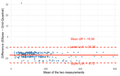
3.3. Field Validity Study
The Bland-Altman analysis indicated a mean bias of −16.98 units (SD = 3.7), with narrow 95% limits of agreement ranging from −24.25 to −9.72 units. The mean absolute difference between methods was 17.19 units. Total gap area estimated by the ellipse method was 38,693.95 units compared with 43,840.4 units from the grid-quadrat method, representing an 11.74% lower estimate by the ellipse method. A very strong linear relationship was observed between the two methods (r = 0.997) (
Table 3).
Graphical and numerical outputs from the Bland-Altman analysis demonstrated a consistent pattern of agreement between the ellipse and grid-quadrat methods, characterized by a small but systematic bias and limited random variability (
Figure 2).
Figure 2. Validity test of using Ellipse and Grid-Quadrat methods complementarily. Validity test of using Ellipse and Grid-Quadrat methods complementarily.
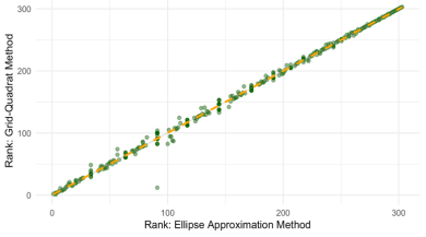
The correlation plot revealed a very strong positive linear relationship between the ellipse and grid-quadrat methods, with a Pearson correlation coefficient of 0.997, indicating that the two methods produce highly consistent relative gap area estimates across the dataset (
Figure 3).
Figure 3. Spearman rank correlation between Ellipse and Grid-Quadrat methods. Spearman rank correlation between Ellipse and Grid-Quadrat methods.
Table 3. Comparison of Ellipse and Grid-Quadrat methods with data from Korup National Park (12 out of 303 values).Comparison of Ellipse and Grid-Quadrat methods with data from Korup National Park (12 out of 303 values).Comparison of Ellipse and Grid-Quadrat methods with data from Korup National Park (12 out of 303 values).
Ellipse Area (M2) | Short Radius (r1) | Long Radius (r2) | Grid Area (M2) | Number of Squares (N) | Area of 1 Square (M2) | Brokaw's classification |
40.50 | 2.93 | 4.40 | 56.24 | 8 | 7.03 | Small gap |
53.50 | 3.37 | 5.05 | 72.22 | 11 | 6.57 | Small gap |
74.50 | 3.98 | 5.96 | 92.62 | 11 | 8.42 | Small gap |
85.40 | 4.26 | 6.39 | 99.90 | 7 | 14.27 | Small gap |
153.50 | 5.71 | 8.56 | 168.02 | 2 | 84.01 | Medium gap |
213.50 | 6.73 | 10.10 | 235.73 | 7 | 33.68 | Medium gap |
292.70 | 7.88 | 11.82 | 314.27 | 7 | 44.90 | Medium gap |
354.90 | 8.68 | 13.02 | 369.40 | 18 | 20.52 | Medium gap |
487.50 | 10.17 | 15.26 | 502.00 | 2 | 251.00 | Large gap |
512.50 | 10.43 | 15.64 | 531.06 | 2 | 265.53 | Large gap |
525.00 | 10.56 | 15.83 | 539.50 | 13 | 41.50 | Large gap |
580.90 | 11.11 | 16.66 | 599.44 | 8 | 74.93 | Large gap |
Correlation coefficient | 0.997 | |
Mean difference (units) | -16.98 | |
Mean absolute difference (units) | 17.19 | |
Standard deviation of the differences | 3.70 | |
Limits of agreement (%) | 95.0 | |
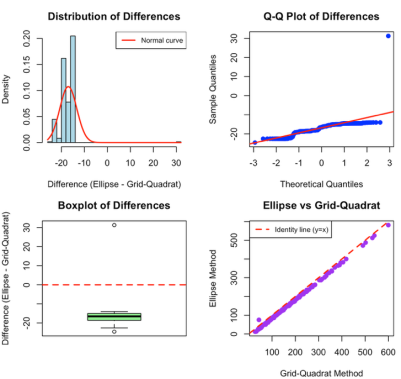
3.4. Paired Sample Comparison Analysis
The paired comparison revealed a clear and statistically robust difference between the ellipse approximation and grid-quadrat methods for estimating gap area. Descriptive statistics showed that the ellipse method consistently produced lower values than the grid-quadrat method (mean difference = −16.99 units), indicating systematic underestimation. This pattern was stable across observations, as reflected by the small standard deviation of the paired differences (SD = 3.71), suggesting high consistency in the magnitude of disagreement between methods. Normality testing of the paired differences strongly rejected the assumption of normality (Shapiro-Wilk p < 0.001), justifying the use of a non-parametric approach. The Wilcoxon signed-rank test confirmed a highly significant difference between methods (p = 2.2e-16), providing strong evidence that the two techniques do not yield identical area estimates.
Although a paired t-test also indicated statistical significance, the non-parametric result is considered more appropriate and robust given the distributional characteristics of the data. The magnitude of the difference was substantial, as indicated by a very large paired effect size (Cohen’s d = −4.58). This implies that the observed discrepancy is not only statistically significant but also practically meaningful. Taken together, these results demonstrate that while the ellipse and grid-quadrat methods are consistently related, they are not interchangeable in terms of absolute gap area estimation. The ellipse method’s systematic underestimation should therefore be accounted for through calibration, correction factors, or complementary use with the grid-quadrat method when precise area quantification is required (
Table 4).
Table 4. Paired comparison between Ellipse Approximation and Grid-Quadrat methods. Paired comparison between Ellipse Approximation and Grid-Quadrat methods. Paired comparison between Ellipse Approximation and Grid-Quadrat methods.
Statistic | Ellipse Method | Grid-Quadrat Method | Paired Difference (Ellipse − Grid) |
Mean | 127.7 | 144.69 | −16.99 |
Median | 100 | 119.07 | −16.54 |
Standard deviation | 90.3 | 91.15 | 3.71 |
Minimum | - | - | −24.56 |
Maximum | - | - | 31.26 |
Shapiro-Wilk W | - | - | 0.563 |
Shapiro-Wilk p-value | - | - | < 0.001 |
Paired t statistic | - | - | −79.80 |
Degrees of freedom | - | - | 302 |
p-value | - | - | < 0.001 |
95% CI of mean difference | - | - | [−17.40, −16.57] |
Wilcoxon V | - | - | 303 |
p-value | - | - | < 0.001 |
Cohen’s d (paired) | - | -−4.58 (Large) |
The graphical diagnostics consistently support the statistical findings of a systematic difference between the ellipse and grid-quadrat methods. The histogram of paired differences shows a clearly non-normal distribution, with the observed differences tightly clustered around a negative mean, indicating consistent underestimation by the ellipse method. This pattern is reinforced by the Q-Q plot, where pronounced deviations from the reference line particularly in the tails, confirm substantial departures from normality. The boxplot further illustrates this bias by showing the median difference well below zero, with relatively limited spread, highlighting both the direction and consistency of the discrepancy between methods. Finally, the scatter plot of ellipse versus grid-quadrat estimates reveals a strong linear relationship, with most points lying below the identity line (y = x), providing clear visual evidence that, although the two methods are highly correlated, the ellipse method systematically yields lower area estimates across the full range of observed gap sizes (
Figure 4).
Figure 4. Scatterplot of differences. Scatterplot of differences.
3.5. Quantitative Results
The results demonstrate a clear advantage of the digital app over the paper-based approach (
Table 5). Average time per gap was reduced from 8.4 minutes to 4.5 minutes, representing a 47% improvement in field efficiency. All observed transcription errors (12 incidents), data loss cases (3 incidents), and classification errors (8 cases) recorded under the paper method were eliminated using the digital app. Furthermore, data availability was immediate with the app, compared with a 2-3 week delay associated with post-field processing of paper records. These outcomes highlight the significant operational benefits of digitized data collection. (
Table 5)
Table 5. Quantitative results per paper method and digital app.
Metric | Paper Method | Digital App | Improvement |
Average time per gap | 8.4 min | 4.5 min | 47% reduction |
Transcription errors | 12 incidents | 0 incidents | 100% reduction |
Data loss incidents | 3 cases | 0 cases | 100% reduction |
Classification errors | 8 cases | 0 cases | 100% reduction |
Time to data availability | 2-3 weeks | Immediate | 100% reduction |
3.6. User Acceptance and Usability
The results indicate very high user acceptance across all evaluated aspects. Participants rated ease of learning with a mean of 4.8 (SD = 0.4), and ease of use in the field at 4.6 (SD = 0.5), demonstrating that the application is both intuitive and practical for on-site data collection. Reliability received the highest score of 4.9 (SD = 0.3), reflecting consistent performance during the study. Participants also indicated strong overall endorsement, with a mean score of 5 for willingness to (
Table 6).
Table 6. User acceptance and usability of the gap management system User acceptance and usability of the gap management system User acceptance and usability of the gap management system
Aspect | Rating (1-5) | SD |
Ease of learning | 4.8 | 0.4 |
Ease of use in field | 4.6 | 0.5 |
Reliability | 4.9 | 0.3 |
Would recommend | 5 | 0 |
Prefer over paper | 4.9 | 0.3 |
Qualitative Feedback Themes
1) Efficiency: "Dramatically reduced time spent on calculations and data entry",
2) Reliability: "No more lost data sheets or illegible notes after rain",
3) Immediate feedback: "Instant classification helps in field decision-making",
4) Data quality: "Automated calculations eliminate arithmetic errors",
5) Convenience: "Single device replaces clipboard, calculator, and data sheets".
Challenges Identified
1) Screen visibility in bright sunlight (addressed with high-contrast mode),
2) Battery management for extended sessions (mitigated through power-saving recommendations),
3) Initial training time (reduced to <30 minutes with improved documentation).
3.7. Cross-Platform Compatibility
All tested platforms and browsers achieved full functionality, indicating robust cross-platform support. On Windows, Chrome (v120+), Firefox (v121+), and Edge (v120+) fully supported all features, with Edge benefiting from its Chromium base. On macOS and iPadOS, Safari (v17+) allowed adding the app to the dock, while on iOS, Safari (v17+) supported adding the app to the Home Screen. Linux testing on Ubuntu 22.04 with Firefox (v121+) confirmed operational consistency. Mobile optimization was particularly effective on Android devices using Chrome (v120+), ensuring seamless field deployment. (
Table 7).
Table 7. Cross platform compatibility per operating system and browser. Cross platform compatibility per operating system and browser. Cross platform compatibility per operating system and browser.
Platform | Browser | Status | Notes |
Windows | Chrome 120+ | ✓ Full | Reference platform |
Windows | Firefox 121+ | ✓ Full | All features functional |
Windows | Edge 120+ | ✓ Full | Chromium-based |
MacOS | Safari 17+ | ✓ Full | Add to dock supported |
Linux | Firefox 121+ | ✓ Full | Tested on Ubuntu 22.04 |
Android | Chrome 120+ | ✓ Full | Optimized for mobile |
iOS | Safari 17+ | ✓ Full | Add to Home Screen supported |
iPadOS | Safari 17+ | ✓ Full | Add to dock supported |
3.8. Offline Functionality Validation
The results demonstrated that all core functions remained fully operational in offline mode. Data entered while offline persisted across browser sessions, ensuring no loss of information. Export functionality was successfully executed without network access, and the application effectively updated cached resources when connectivity was restored (
Table 8).
Table 8. Offline functionality validation per various scenarios. Offline functionality validation per various scenarios. Offline functionality validation per various scenarios.
Test Scenario | Observed Result | Notes |
Complete offline operation after initial cache | Fully operational | All core features functional |
Data entry without connectivity | Data persisted | No information loss across sessions |
Export functionality offline | Successful export | Export generation independent of network |
Application updates on connectivity restoration | Cache updated | Application synchronized when reconnected |
3.9. Data Integrity and Validation
The results demonstrated that the application maintained complete data integrity throughout the testing period. No data corruption incidents were observed, export-import cycles preserved 100% of the original data, audit trails remained intact for all entries, and classification of records was consistent across successive edits. These findings confirm that the digital PWA ensures reliable and accurate data management, supporting its suitability for long-term ecological field studies and other research requiring robust data governance (
Table 9).
Table 9. Data integrity upon long term testing. Data integrity upon long term testing. Data integrity upon long term testing.
Validation Aspect | Observed Result | Notes |
Data corruption incidents | 0 | No incidents over 3 months and 500+ records |
Export-import cycle fidelity | 100% | All data preserved accurately |
Audit trail preservation | Complete | All entries tracked consistently |
Classification consistency | Consistent | No discrepancies across edits |
4. Discussion
The validation results demonstrate that Progressive Web Applications can effectively support rigorous scientific fieldwork while addressing long-standing operational challenges in forest ecology research. The observed 47% reduction in data collection time translates into substantial efficiency gains for research projects, potentially enabling more extensive sampling within fixed logistical and budgetary constraints. This efficiency improvement aligns with broader trends in digital ecological research, where mobile technologies have been shown to enhance field productivity while reducing operational costs
| [57] | Teacher, A. G. F., Griffiths, D. J., Hodgson, D. J., and Inger, R. Smartphones in ecology and evolution: a guide for the app-rehensive. Ecology and Evolution. 2013, 3(16), 5268-5278. https://doi.org/10.1002/ece3.888 |
| [58] | Inman-Narahari, F., Giardina, C., Ostertag, R., Cordell, S., and Sack, L. Digital data collection in forest dynamics plots. Methods in Ecology and Evolution. 2010, 1(3), 274-279.
https://doi.org/10.1111/j.2041-210X.2010.00034.x |
[57, 58]
. The elimination of transcription errors represents a major improvement in data quality, as such errors can propagate through subsequent analyses and compromise research outcomes. Previous studies have documented error rates of up to 15% in manual data collection and transcription processes
| [15] | Terryn, L. et al. Correction to “New tree height allometries derived from terrestrial laser scanning reveal substantial discrepancies with forest inventory methods in tropical rainforests”. Global Change Biology. 2024, 30(12).
https://doi.org/10.1111/gcb.17473 |
[15]
, making the complete elimination of these errors a significant advancement. Moreover, the automated classification system ensures consistency in applying Brokaw's (1982) framework, removing subjective interpretation that can lead to misclassification in paper-based workflows.
The immediate availability of classified data enables adaptive sampling strategies, allowing researchers to modify field protocols in response to real-time gap distribution patterns. This level of responsiveness was previously unattainable with paper-based workflows requiring post-fieldwork digitization and processing delays of 2-3 weeks. Several participants reported adjusting sampling intensity after reviewing preliminary gap size distributions in the field, demonstrating the practical value of instant feedback for improving study design and decision-making. This capability is particularly valuable in tropical forest research, where access to field sites may be limited by weather, logistics, or seasonal constraints.
4.1. Method Comparison and Validation
The digital workflow established by the PWA provided the foundation for robust method comparison and validation. By ensuring rapid, error-free data capture and immediate processing, discrepancies between measurement methods could be attributed to methodological differences rather than data handling artifacts, strengthening confidence in the comparative analyses. The Bland-Altman analysis revealed moderate agreement between the ellipse approximation and grid-quadrat methods, with a systematic bias of -16.98 units indicating that the ellipse method consistently underestimates gap areas by approximately 17 units relative to the grid-quadrat approach. The narrow 95% limits of agreement (-24.25 to -9.72 units) and low standard deviation (3.7 units) demonstrate minimal random variation beyond this systematic bias. The mean absolute difference of 17.19 units and overall 11.74% relative difference confirm that while the bias is consistent, it remains relatively small in magnitude.
These findings indicate good overall agreement between methods, particularly regarding consistency, though the ellipse method exhibits a predictable tendency toward underestimation. The narrow limits of agreement suggest minimal random error, with observed differences largely explained by systematic bias rather than measurement inconsistency. The correlation coefficient of 0.997 provides compelling evidence that the methods are highly comparable in relative performance and can be used complementarily or even interchangeably for most practical applications such as ranking gaps by size, detecting spatial patterns, or making relative comparisons across forest plots. The paired-sample analysis corroborates these findings, demonstrating a statistically and practically significant difference between methods. The strong rejection of normality for paired differences (Shapiro-Wilk p < 0.001) justified non-parametric testing, and the highly significant Wilcoxon signed-rank result (p = 2.2e-16) confirmed systematic rather than random discrepancy. The very large effect size (Cohen's d = -4.58) indicates substantial practical implications for absolute gap area estimates, particularly in studies where total gap area or biomass-related metrics are central outcomes.
Such method-dependent bias is common in ecological measurement studies, where simplified geometric approximations tend to underestimate irregular or complex spatial features compared with detailed sampling-based techniques
| [48] | Bland, J. M., and Altman, D. G. Statistical methods for assessing agreement between two methods of clinical measurement. The Lancet. 1986, 327(8476), 307-310.
https://doi.org/10.1016/S0140-6736(86)90837-8 |
| [59] | Korhonen, L., Korhonen, K. T., Rautiainen, M., and Stenberg, P. Estimation of forest canopy cover: A comparison of field measurement techniques. Silva Fennica. 2006, 40(4), 577-588. https://doi.org/10.14214/sf.315 |
[48, 59]
. The consistency of this underestimation across gaps makes it predictable and amenable to correction. These results align with previous findings that rapid field-based approximations trade some accuracy for efficiency
| [60] | Jennings, S. B., Brown, N. D., and Sheil, D. Assessing forest canopies and understorey illumination: canopy closure, canopy cover and other measures. Forestry. 1999, 72(1), 59-74.
https://doi.org/10.1093/forestry/72.1.59 |
| [61] | White, J. C. et al. Best practices guide for generating forest inventory attributes from airborne laser scanning data using an area-based approach. The Forestry Chronicle. 2013, 89(6), 722-723. https://doi.org/10.5558/tfc2013-132 |
[60, 61]
, though the high correlation demonstrates that both methods capture gap size patterns reliably. From a practical perspective, these findings support the complementary use of both methods: the ellipse approximation for rapid assessments and relative comparisons where field efficiency is paramount, and the grid-quadrat method where higher spatial fidelity is required for absolute area quantification. Where absolute accuracy is critical for specific research objectives, applying a calibration factor (approximately +13% adjustment) or averaging estimates from both methods may effectively mitigate systematic bias without sacrificing operational efficiency
. The PWA's implementation of both methods within a single interface facilitates this flexible approach, allowing researchers to select the most appropriate technique for their specific research questions and field conditions.
4.2. Digital Tool Performance and User Acceptance
The quantitative results demonstrate that the digital PWA substantially improves both efficiency and data quality. Beyond the 47% time reduction per gap, the elimination of all transcription errors, data loss incidents, and classification errors reduces the risk of propagating inaccuracies into downstream analyses. The immediate data availability enables adaptive field strategies and more timely decision-making, addressing a critical limitation of traditional paper-based workflows identified by Michener (2015) and Reichman et al. (2011).
User acceptance results indicate strong endorsement across all evaluated dimensions, with particularly high ratings for reliability (4.9/5.0) and willingness to recommend (5.0/5.0). The ease of learning rating (4.8/5.0) suggests that the application successfully minimizes training requirements, an important consideration for field teams with varying technical backgrounds. Qualitative feedback emphasized efficiency gains, elimination of lost data, instant classification feedback, automated calculation accuracy, and device consolidation as key benefits. Identified challenges, including screen visibility in bright sunlight and battery management for extended sessions, were addressed through high-contrast display modes and power-saving recommendations. The brief initial training period (<30 minutes) compares favorably with specialized forestry software requiring extensive instruction
, supporting the user-centered design approach.
4.3. Technical Performance and Reliability
The application's technical performance metrics exceeded established benchmarks for mobile web applications. The 1.2-second initial load time and minimal 2.4 MB offline cache size demonstrate efficient resource utilization suitable for devices with limited storage capacity. Calculation response times under 10 milliseconds ensure seamless user experience during rapid data entry, while battery consumption of only 12% during 8-hour field sessions addresses a critical constraint for extended fieldwork in locations without reliable power access. Cross-platform compatibility testing confirmed full functionality across all major operating systems and browsers, addressing the fragmentation problem that often limits digital tool adoption in diverse research contexts
| [23] | Howard, L., van Rees, C. B., Dahlquist, Z., Luikart, G., and Hand, B. K. A review of invasive species reporting apps for citizen science and opportunities for innovation. NeoBiota. 2022, 71, 165-188.
https://doi.org/10.3897/neobiota.71.79597 |
[23]
. The consistent performance on iOS, Android, Windows, macOS, and Linux platforms eliminates hardware dependencies that can create barriers for resource-constrained research programs.
Offline functionality validation demonstrated complete operational independence from network connectivity, a critical requirement for tropical forest research in remote locations. All core features; data entry, calculation, classification, and export functioned reliably without internet access, with data persisting across sessions and application updates occurring automatically upon connectivity restoration. This addresses a fundamental limitation of many existing digital forestry tools identified by Liang et al. (2016) and Wilkinson et al. (2018). Long-term data integrity testing over three months and more than 500 records confirmed zero data corruption incidents, 100% export-import fidelity, complete audit trail preservation, and consistent classification across edits. These results demonstrate that the PWA architecture provides data reliability comparable to specialized desktop applications while offering superior accessibility and deployment flexibility.
4.4. Implications for Forest Research Practice
The successful implementation and validation of this PWA have several important implications for forest ecology research practice. First, the demonstration that sophisticated measurement protocols can be implemented in universally accessible web technologies challenges the assumption that specialized software and hardware are necessary for rigorous field data collection. This accessibility could substantially broaden participation in forest gap research, particularly for institutions and researchers in developing countries where advanced technological infrastructure may be limited
. Second, the elimination of the digitization phase in the research workflow represents more than just time savings. It fundamentally changes the research process by enabling real-time data exploration and adaptive sampling. This capability is particularly valuable for studies investigating gap dynamics across environmental gradients or disturbance regimes, where preliminary results may inform subsequent sampling strategies. The ability to export standardized CSV files directly from the field also facilitates rapid sharing of preliminary results with collaborators and stakeholders.
Third, the application's implementation of validated measurement protocols in a standardized digital format addresses calls for improved reproducibility and comparability in forest gap research
. By ensuring consistent application of measurement methods and classification systems, the tool supports meta-analyses and synthetic research across geographic regions and forest types. The inclusion of complete calculation parameters in exported data also enhances transparency and enables verification of results. Fourth, the successful deployment of PWA technology in challenging field conditions demonstrates the maturity of web platform capabilities for scientific applications. The offline-first architecture, achieved through service workers and local storage, proves that web applications can provide reliability previously associated only with native software. This finding has broader implications beyond forestry, suggesting that PWA approaches could benefit field research across ecological disciplines.
4.5. Limitations and Future Directions
While the validation results are encouraging, several limitations warrant consideration. The field testing was conducted primarily in tropical forest environments, and performance in other ecosystem types (temperate forests, boreal regions) should be verified to ensure broad applicability. Although cross-platform testing was comprehensive, long-term reliability studies across diverse device models and operating system versions would strengthen confidence in the application's robustness. The current implementation focuses on two measurement methods (ellipse approximation and grid-quadrat), but forest gap research employs various additional techniques including polygon boundary mapping, diameter measurements, and volumetric assessments
| [11] | Yamamoto, S. I. Forest gap dynamics and tree regeneration. Journal of Forest Research. 2000, 5, 223-229.
http://dx.doi.org/10.1007/BF02767114 |
| [13] | Runkle, J. R. Guidelines and sample protocol for sampling forest gaps. General Technical Report PNW-GTR-283. Portland, OR: U.S. Department of Agriculture, Forest Service, Pacific Northwest Research Station; 1992, 44 p. |
[11, 13]
. Future development could incorporate these alternative approaches while maintaining the application's simplicity and user-friendliness. Integration with GPS coordinates would enable spatial analysis of gap distributions, while photograph capture and storage would support detailed documentation and post-hoc verification.
The application currently operates as a standalone tool, but integration with broader research data management platforms could enhance its utility. Optional cloud synchronization would enable real-time collaboration among research teams, though maintaining offline-first functionality must remain the priority. Connection to emerging forest monitoring networks and remote sensing databases could provide additional context for ground-based gap measurements. Advanced analytical capabilities, such as gap size distribution modeling, temporal change detection, and predictive analytics for regeneration potential, could be incorporated while preserving the application's core simplicity. Machine learning approaches for automated gap boundary detection from smartphone images represent an exciting frontier, though ground-truthing against manual measurements would remain essential
| [8] | Dalagnol, R. et al. Quantifying canopy tree loss and gap recovery in tropical forests under low-intensity logging using VHR satellite imagery and airborne LiDAR. Remote Sensing. 2019, 11(7), 817. https://doi.org/10.3390/rs11070817 |
| [20] | Wallace, L., Lucieer, A., Malenovský, Z., Turner, D., and Vopěnka, P. Assessment of forest structure using two UAV techniques: A comparison of airborne laser scanning and structure from motion (SfM) point clouds. Forests. 2016, 7(3), 62. https://doi.org/10.3390/f7030062 |
[8, 20]
. Community engagement through open-source publication would facilitate ongoing improvement, adaptation to diverse research contexts, and extension to related applications beyond forest gap assessment. Collaborative development could address specific needs of different research communities while maintaining standardization in core functionality and data formats.