Geotourism or land tourism is considered a relatively new concept in tourism industry that has gained a considerable growth and attention in the recent decade. Geotourism can have the most harmony with sustainable development and all economic, cultural, social and environmental dimensions. The present paper aims to study an attractive geomorphotourism site around the city of Mashhad. To this end, several Geomorphosites resulting from the erosion process were selected for tourism development and their capabilities were evaluated. To evaluate geomorphotourism development potentials of the study area, Pereira method was used and field data collection and evaluation were conducted applying a Geographical Information System (GIS). By evaluating the scientific index of the selected Geomorphosites, it was found that dolines obtained the highest score followed by rock walls. For the complementary index, the highest score belongs to the rock walls and Akhlamad main waterfall, respectively. For the protection index, dolines, rock walls, and karst valleys had the highest scores, respectively. For the usage index, rock walls obtained the highest score followed by Akhlamad River. Scientific findings of the documentary and field studies showed that Akhlamad has significant potential for adventure and educational tourism, and mountain and winter sports due to the development of morphological-hydrological landscapes. The results also indicated that to make optimal use of the geotourism potential of Akhlamad, should be considered.
| Published in | Earth Sciences (Volume 14, Issue 1) |
| DOI | 10.11648/j.earth.20251401.11 |
| Page(s) | 1-16 |
| Creative Commons |
This is an Open Access article, distributed under the terms of the Creative Commons Attribution 4.0 International License (http://creativecommons.org/licenses/by/4.0/), which permits unrestricted use, distribution and reproduction in any medium or format, provided the original work is properly cited. |
| Copyright |
Copyright © The Author(s), 2025. Published by Science Publishing Group |
Geomorphotourism, GIS, Pereira Evaluation Method, Akhlamad, Geotourism Sites
Intact geomorphological phenomenon | Score |
|---|---|
Highest damage by human activities | 0 |
Major forms damaged by natural factors | 0.25 |
Damaged if the original forms are intact | 0.50 |
Minor damage if major defects remain | 0.75 |
No damage in forms | 1 |
The number of attractive and diverse geomorphic forms | score |
1 | 0 |
2 | 0.33 |
3 | 0.67 |
>3 | 1 |
The scarcity of landscapes at the national level | Score |
More than five samples nationally | 0 |
Between three and five samples nationally | 0.17 |
Three samples nationally | 0.33 |
Rare and unique nationally | 0.50 |
Scientific studies in geomorphological journals | Score |
Lack of related papers | 0 |
Presentation in seminars and scientific and research papers (intermediate) | 0.25 |
Presentation of international papers and academic dissertations (high) | 0.35 |
Rarity relative to the area | Score |
Absence of the phenomenon among the first five samples | 0 |
Absence of the phenomenon among the first three samples | 0.25 |
As one of the three sample phenomena | 0.50 |
As a very important phenomenon | 0.75 |
A phenomenon with the exceptional occurrence | 1 |
Educational value of geomorphic processes | Score |
Limited visual value with no educational attractions | 0 |
Limited visual value with limited educational attractions | 0.38 |
Appropriate sample of processes and difficult description for non-experts | 0.67 |
A good sample of processes and a good educational resource | 1 |
Other geological forms with a valuable heritage | Score |
No other geological forms | 0 |
Existence of other forms unrelated to geomorphology | 0.17 |
Existence of other forms related to geomorphology | 0.33 |
Existence of other Geomorphosites with heritage value | 0.50 |
Cultural value | Score |
|---|---|
No or damaged cultural forms | 0 |
Cultural forms unrelated to landforms | 0.25 |
Appropriate cultural forms unrelated to landforms | 0.50 |
Insignificant cultural forms related to landforms | 0.75 |
Material cultural forms related to landforms | 1 |
Appropriate cultural forms related to landforms | 1.25 |
Primitive landforms or high cultural relevance | 1.50 |
Ecological value | Score |
Unrelated to biological forms | 0 |
Plant and animal attractions | 0.38 |
The best place to see plant and animal attractions | 0.75 |
The importance of geomorphological forms for the ecosystem | 1.12 |
The high importance of geomorphological forms for the ecosystem | 1.50 |
Aesthetic value | Score |
Thematic value: Landscape's visual uniqueness, landscape, landscape diversity, landforms color combinations, water and plant, no human destruction, proper access to observed forms | |
Low | 0-0.5 |
Middle | 0.5-1 |
high | 1-1.5 |
Intactness | Score |
|---|---|
Damaged by human activities | 0 |
Damaged by natural processes | 0.25 |
Damaged with the original geomorphological forms retained | 0.50 |
Low damage with the original geomorphological forms retained | 0.75 |
No damage and the original geomorphological forms retained | 1 |
Vulnerability if using the site | Score |
High vulnerability, with the possibility of loss and total destruction | 0 |
Probable damage to geomorphological forms if used | 0.50 |
Probable damage to non-geomorphological forms if used | 1 |
Damage only to access networks (transportation) | 1.5 |
Improbable vulnerability if used | 2 |
Access rate | Score |
|---|---|
Difficult access and accessible only by a special tool | 0 |
Access only by car and 500 meters on foot | 0.21 |
Access by car and more than 500 meters on foot | 0.43 |
Access by car and less than 500 meters on foot | 0.64 |
Access by car and less than 100 meters on foot | 0.86 |
Access by car and less than 50 meters on foot | 1.07 |
Access by bus on the side road and less than 50 meters on foot | 1.29 |
Access by bus on the main road and less than 50 meters on foot | 1.50 |
Current use of geomorphological attractions | Score |
Not upgraded and not used | 0 |
Not upgraded and used | 0.33 |
Upgraded as a site with landscapes | 0.67 |
Upgraded as a geosite | 1 |
Current use of other cultural and natural attractions | Score |
No other attractions, Not upgraded, not used | 0 |
Other attractions, Not upgraded, not used | 0.33 |
Other attractions, upgraded, not used | 0.67 |
Other attractions, upgraded, used | 1 |
Visibility | Score |
Very poor visibility or invisible in all areas | 0 |
Only visible by special tools (artificial light) | 0.30 |
Limited visibility due to short and small trees and plants | 0.60 |
Good visibility but requires little movement | .090 |
Good visibility for all geomorphological forms | 1.20 |
High visibility for all geomorphological forms. | 1.50 |
Equipment and support service | Score |
24-hour support service and > 25 km away from the attraction | 0 |
24-hour support service and 5-10 km away from the attraction | 0.50 |
24 hours a day with support service and < 5 km away from the attraction | 0.75 |
24-hour support service and < 5 km away from the attraction | 1 |
Protection rules and usage restrictions | Score |
Full protection and no use | 0 |
Protection and limited use | 0.33 |
No protection and unlimited use | 0.67 |
Protection and unlimited use or very few limitations on use | 1 |
Features | Natural properties |
|---|---|
River | The river is referred to as the bed and the path of a stream. Rivers primarily form alluvial fans at the foot of the mountains, and then contribute to the development of the plains by accumulating alluviums along the route. |
Rock walls | Walls are rocks higher than 50 meters, which are more than one rope length with a slope of more than 75°. They have different types of rocks, slopes, and hardness, which is also called ''steep''. The walls are elevated, natural, and impassable sidewalks with steep cliffs and are considered a part of the mountain. |
Karst valleys | A valley is a long depression between two hills that extends in one direction. Karst valleys are U-shaped narrow deep or V-shaped dry asymmetric or a combination of the two. River valleys formed by river movements are usually v-shaped. Their shape depends on the flow characteristics. |
Calcareous holes (dolins) | These forms are among the most significant morphological karst phenomena in the Akhlamad drainage basin. The dolins observed are of dissolution type and are formed by the dissolution of limestone rocks. Scattered dolins and relatively deep holes in the basin surface indicate geomorphic maturation of karst. |
Waterfall | A waterfall is a geological phenomenon in which the water of a river flows from a plateau or high place at high velocity into a plunge pool below. A waterfall is an abrupt drop of water, usually caused by a rocky ledge in a river that is either horizontal or gently sloping toward the top of the river and settles on softer rocks. The softer rocks below are eroded quicker than the harder rocks so that the harder rocks may hang and eventually a waterfall forms. |
Jama and calcareous caves | Jama is a vertical or near-vertical karst channel that open to the ground. The area of the caves in the Akhlamad drainage basin is not very large and there are few helictite shapes and calcite dripping stones. Most of these caves are almost dry. The largest cave in the basin is Akhlamad Cave with a length of 17.5 meters near the first waterfall of Akhlamad. |
Akhlamad valley Geomorphosites | Geomorphological values | Managerial values | Total scores in the Pereira model | |||
|---|---|---|---|---|---|---|
Highest scientific index 5.5 | Highest complementary index 4.5 | Highest usage index 7 | Highest protection index 3 | |||
1 | River | 1.88 | 1.88 | 4.97 | 0.5 | 9.23 |
2 | Rock walls | 4.75 | 3.87 | 5.17 | 1.25 | 15.04 |
3 | Ajenneh karst valley | 3.75 | 3.38 | 4.67 | 1.25 | 13.05 |
4 | Karst sinkholes (dolins) | 4.67 | 2.63 | 3.77 | 1.5 | 12.57 |
5 | Akhlamad main waterfall | 3.55 | 3.57 | 5.6 | 0.75 | 13.47 |
6 | Calcareous cave | 2.55 | 2.7 | 1.83 | 0.75 | 7.83 |
ACECR | Academic Centre of Education, Culture and Research |
GIS | Geographical Information System |
STEM | Technology, Engineering and Mathematics |
UNESCO | United Nations Educational, Scientific and Cultural Organization |
| [1] | Allan, M. Geotourism: An opportunity to enhance geoethics and boost geoheritage appreciation. Geological Society, (Special Publications), 419, pp. 25 – 29. |
| [2] | Arab Ameri, A. R. (2015). Comparative evaluation of geomorpho-desert sites in Shahrood County towards sustainable tourism development, Geographical explorations of desert areas, 5, pp. 49 – 69 [in Persian]. |
| [3] | Baboli Moakhar, H.; Negahban, S. (2001). Introduction and Capability Assessment of Geotourism Capabilities of Bahmai County Using Pereira & Reynard Models, Physical Geography, 57, pp. 63 – 90 [in Persian]. |
| [4] | Bazargani Gilani, K.; Qureshi Nia, S. K.; Karimzadeh, Z. (2012). Geology and characteristics of carbonate bed of Akhlamd lead and zinc deposit, West Chenaran, Eastern Alborz, Iran, 4th Conference of Iranian Economic Geological Society, Birjand, 8-10 September 2012. [In Persian]. |
| [5] | Chorley, R. J. (1996). Geomorphology: Volume One, Translated by Ahmad Motamed, Samt Publication [in Persian]. |
| [6] | Comanescu, L., Nedelea, A., & Dobre, R. (2001). Evaluation of geomorpho-sites in Vistea Valley (Fagaras Mountains-Carpathians, Romania). International Journal of the Physical Sciences, 6, pp. 1161-1168. |
| [7] | Comanescu, L., & Dobre, R. (2009). Inventorying Evaluating and Tourism Valuating the Geomorphosite from the Central Sector of Tourism and Geosites. Journal of Tourism and Geosites, 1(3), pp. 86-96. |
| [8] | Dowling, R. K., & Newsome, D. (2006). Geotourism’s Issues and Challenges. Geotourism, Chapter Thirteen. Oxford: Elsevier. |
| [9] | Ekinci, D. (2010). The Noticeable Geomorphosites of Turky. International Journal of Art and Science, 3(15), pp. 303-321. |
| [10] | Fotouhi, S., Aghazadeh, Z., Rahimi, D. (2012). Evaluation of Geomorphotourism capabilities of landforms based on Pralong method, case study; Biston Tourism Area. Journal of Applied Research in Geographical Sciences, 12(26), pp. 23-46 [in Persian]. |
| [11] | Gray, M. (2011). Other nature: Geodiversity and geosystem services. Environmental Conservation, 38(3), pp. 271–274. |
| [12] | HajAliLou, B., & Nekouei Sadri, B. (2011). Geotourism. Tehran: Payame Noor University Press [In Persian]. |
| [13] | Hejazi, S. A.; Zali Korde Mahini, A.; Jafari, M. (2002). Evaluation of Geotourism Capabilities of Geomorphosites of Osku County in East Azerbaijan Province Using Pereira and Pralong Method, Geography and Human Relations, 22, pp. 560 – 589 [in Persian]. |
| [14] | Hose T. (1995a). Selling the story of Britain’s stone. Environmental Interpretation, 10(2), pp. 16–17. |
| [15] | Hose, T. A. (1995b). Evaluating interpretation at Hunstanton. Earth Heritage 4-20. |
| [16] | Hose, T. A. (2000a). European Geotourism – Geological Interpretation and Geoconservation Promotion for Tourists. Geological Heritage: Its Conservation and Management. Madrid. |
| [17] | Hose, T. A. (2000b). European Geotourism: An overview of the promotion of geoconservation through interpretative provision. Symposium Zukunftsfähiger Geotourismus – Ein Baustein zur lokalen Agenda 21. Bad Urach. |
| [18] | Hose, T. A. (2003). Geotourism in England: A two-region case study analysis. (Unpublished doctoral dissertation). Birmingham University, UK. |
| [19] | Hose, T. A. (2006). Leading the field: a contextual analysis of the field-excursion and the field-guide in England. Proceedings of the Critical Issues in Leisure and Tourism Education Conference. High Wycombe. |
| [20] | Hose, T. A. (2008). Towards a history of Geotourism: definitions, antecedents and the future, The History of Geoconservation – Special Publication 300. London. |
| [21] | Hose, T. (2012). 3 Gs for modern geotourism. Geoheritage, 4, pp. 7–24. |
| [22] | Ielenicz, M. (2009). Geotope, Geosite, Geomorphosite. The Annals of Valahia University of Targoviste, Geographical Series, 9, pp. 7-22. |
| [23] | Industry, Mining, and Trade Organization of Khorasan Razavi Province. (2022). Retrieved on 31 October 2022. |
| [24] | Khoshraftar, R. (2010). Geomitology, Earth Sciences and Oral Culture. Journal of Geographical Space, 1(36), pp. 211-233 [in Persian]. |
| [25] | Maghsoudi, M., Alizadeh, M. R., Bahrabadi, S., Hedayi Arani, M. (2012). Evaluation of Geomorphosite capability of Kavir National Park. Tourism Management Studies, 19, pp. 49-68 [in Persian]. |
| [26] | Maghsoudi, M., & Rahimi Bahrabadi, S. (2014). Geotourism Development Strategies in Desert and Desert Areas of Iran: Case Study: Kavir National Park, Proceedings of the Regional Conference on Tourism and Development, Islamic Azad University, Yasouj [in Persian]. |
| [27] | Mahmodi, F. (1988). The Evolution of Reliefs in Iran during Quaternary, Journal of Geographical Researches of the Institute of Geography, 23, pp. 5-43. |
| [28] | Mirkatoli, J.; Zangiabadi, Z.; Aflaki, Z.; Moussazadeh, H. (2016). Assessment of geological heritage in Cheshmeh Badab-Surt Geopark using the Pereira and Reynard methods, Regional Planning, 21, pp. 219-205 [in Persian]. |
| [29] | Mokhtari, D. (2010). Evaluation of Ecotourism Capacity of Geomorphic Locations of Ruined Mill Watershed in Northwest Iran by Peralong Method. Geography and Development, 52 pp. 18-27 [in Persian]. |
| [30] | Negaresh, H., Khaledi, Sh., Golkarami, A., & Zandi, R. (2009). Geotouristic attractions of golfers in Sistan and Baluchestan province. Environmental planning, 2(6), pp. 78-97 [In Persian]. |
| [31] | Nekouie Sadri, B. (2009). Fundamentals of Geotourism with Special Emphasison Iran, Samt Publications, Tehran [in Persian]. |
| [32] | Newsome, D., & Dowling, R. K. (Eds). (2010). Geotourism: The tourism of geology and landscape. Goodfellow Publishers Limited, Oxford, UK. |
| [33] | Newsome, D., Dowling, R. K., & Yu-Fai, L. (2012). The nature and management of geotourism: A case study of two established iconic geotourism destinations. Tourism Management Perspectives, 2-3, pp. 19–27. |
| [34] | Ollier, C. (2012). Problems of geotourism and geodiversity. QUAESTIONES GEOGRAPHICAE, 3(31), pp. 57–61. |
| [35] | Pereira, P., Pereira, D., and Caetano Alves M. I. (2007). Geomorphosite assessment in Montesinho natural park (Portugal). Geographica Helvetica, 62(3), pp. 159–168. |
| [36] | Pour Latifi, A. (2006). Akhlamd Geological Map, Geological Survey of Iran, Tehran. |
| [37] | Pourfaraj, A., Ghaderi, E., Jomehpour, M. (2020). Conservation Management of Geotourism Attractions in Tourism Destinations, Geoheritage 12, 80. |
| [38] | Reynard, E., Fontana, G., Kozlik, L. & Scapozza, C. (2007). A method for assessing scientific and additional values of Geomorphosites. Geographica Helvetica, 62(3), pp. 148-58. |
| [39] | Rezaei, M., Nakhaei, M. (2008). How to form a karst cave in Katlekhor in Zanjan province. Geology of Iran, 2(6), pp. 11-19 [in Persian]. |
| [40] | Salamzadeh, A., Ebrahimi, P., Soleimani, M. (2021). An AHP Approach to Identify the Barriers of Sustainable Geotourism Development in Iran: An Economic View. Geoheritage, pp. 13, 65. |
| [41] | Seyed Asadollah H, Setareh Farmani, M. (2017). Geotourism potential evaluation of geomorpho-sites in Varkaneh village using the Periera method, Geography and Planning, (59)21, pp. 41-63 [in Persian]. |
| [42] | Sheikh, M. R. (2009). Tourism Guide of Khorasan Provinces (Razavi, North, South), mashhad: Arsalan Press [In Persian]. |
| [43] | Yazdi, A., Emami, M. H., & Jafari, H. R. (2013). IRAN, the Center of Geotourism Potential. Journal of Basic and Applied Scientific Research, 3(1s) pp. 458-465. |
| [44] | Zahmatkesh Maremi, H.; Hosseinzadeh, M.; Rawan, N.; Sadough, S. H.; Mahmoudi, F. (2017). Geomorphotourism and assessment of the potential of geomorphosites in Qeshm Geopark using the Pereira method, Geography (Regional Planning), 8(1), pp. 251–263 [in Persian]. |
| [45] | Zanganeh Asadi, M. A., Ghayur, H. A., Ramesht, M. H., & Velayati, S. (2002). Karst landscapes of Akhlamd basin and its environmental management. Geographical Research, 42, pp. 87-101 [in Persian]. |
| [46] | Zanganeh Asadi, M. A., Amirahamdi, A., Shayan Yeganeh, A. (2016). A New Approach in the Evaluation of Geomorphosites and Geosites in Iran. Quarterly Journal of Tourism Management Studies, 11(34), pp. 4-24 [in Persian]. |
APA Style
Tavangar, M., Forghani, A. (2025). The Development of Geotourism in the Akhlamed Valley in Eastern Iran Through the Evaluation of Geomorphosites. Earth Sciences, 14(1), 1-16. https://doi.org/10.11648/j.earth.20251401.11
ACS Style
Tavangar, M.; Forghani, A. The Development of Geotourism in the Akhlamed Valley in Eastern Iran Through the Evaluation of Geomorphosites. Earth Sci. 2025, 14(1), 1-16. doi: 10.11648/j.earth.20251401.11
AMA Style
Tavangar M, Forghani A. The Development of Geotourism in the Akhlamed Valley in Eastern Iran Through the Evaluation of Geomorphosites. Earth Sci. 2025;14(1):1-16. doi: 10.11648/j.earth.20251401.11
@article{10.11648/j.earth.20251401.11,
  author = {Masoomeh Tavangar and Alan Forghani},
  title = {The Development of Geotourism in the Akhlamed Valley in Eastern Iran Through the Evaluation of Geomorphosites
},
  journal = {Earth Sciences},
  volume = {14},
  number = {1},
  pages = {1-16},
  doi = {10.11648/j.earth.20251401.11},
  url = {https://doi.org/10.11648/j.earth.20251401.11},
  eprint = {https://article.sciencepublishinggroup.com/pdf/10.11648.j.earth.20251401.11},
  abstract = {Geotourism or land tourism is considered a relatively new concept in tourism industry that has gained a considerable growth and attention in the recent decade. Geotourism can have the most harmony with sustainable development and all economic, cultural, social and environmental dimensions. The present paper aims to study an attractive geomorphotourism site around the city of Mashhad. To this end, several Geomorphosites resulting from the erosion process were selected for tourism development and their capabilities were evaluated. To evaluate geomorphotourism development potentials of the study area, Pereira method was used and field data collection and evaluation were conducted applying a Geographical Information System (GIS). By evaluating the scientific index of the selected Geomorphosites, it was found that dolines obtained the highest score followed by rock walls. For the complementary index, the highest score belongs to the rock walls and Akhlamad main waterfall, respectively. For the protection index, dolines, rock walls, and karst valleys had the highest scores, respectively. For the usage index, rock walls obtained the highest score followed by Akhlamad River. Scientific findings of the documentary and field studies showed that Akhlamad has significant potential for adventure and educational tourism, and mountain and winter sports due to the development of morphological-hydrological landscapes. The results also indicated that to make optimal use of the geotourism potential of Akhlamad, should be considered.
},
 year = {2025}
}
TY  - JOUR
T1  - The Development of Geotourism in the Akhlamed Valley in Eastern Iran Through the Evaluation of Geomorphosites

AU  - Masoomeh Tavangar
AU  - Alan Forghani
Y1  - 2025/02/07
PY  - 2025
N1  - https://doi.org/10.11648/j.earth.20251401.11
DO  - 10.11648/j.earth.20251401.11
T2  - Earth Sciences
JF  - Earth Sciences
JO  - Earth Sciences
SP  - 1
EP  - 16
PB  - Science Publishing Group
SN  - 2328-5982
UR  - https://doi.org/10.11648/j.earth.20251401.11
AB  - Geotourism or land tourism is considered a relatively new concept in tourism industry that has gained a considerable growth and attention in the recent decade. Geotourism can have the most harmony with sustainable development and all economic, cultural, social and environmental dimensions. The present paper aims to study an attractive geomorphotourism site around the city of Mashhad. To this end, several Geomorphosites resulting from the erosion process were selected for tourism development and their capabilities were evaluated. To evaluate geomorphotourism development potentials of the study area, Pereira method was used and field data collection and evaluation were conducted applying a Geographical Information System (GIS). By evaluating the scientific index of the selected Geomorphosites, it was found that dolines obtained the highest score followed by rock walls. For the complementary index, the highest score belongs to the rock walls and Akhlamad main waterfall, respectively. For the protection index, dolines, rock walls, and karst valleys had the highest scores, respectively. For the usage index, rock walls obtained the highest score followed by Akhlamad River. Scientific findings of the documentary and field studies showed that Akhlamad has significant potential for adventure and educational tourism, and mountain and winter sports due to the development of morphological-hydrological landscapes. The results also indicated that to make optimal use of the geotourism potential of Akhlamad, should be considered.

VL  - 14
IS  - 1
ER  -
Science, Technology, Engineering and Mathematics (STEM), University of South Australia, Adelaide, Australia; Faculty of Science & Technology, University of Canberra, Canberra, Australia
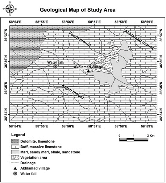
Figure 1. Geographical location of the study area on the geological map 1: 100000. Source: Geological Survey of Iran, 2006.
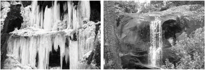
Figure 2. Akhlamad waterfalls in winter and spring.
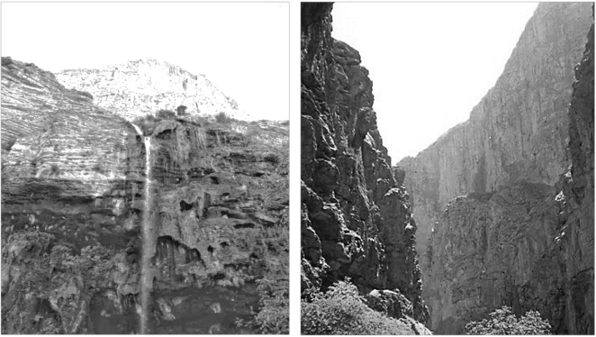
Figure 3. Akhlamad Valley Walls.
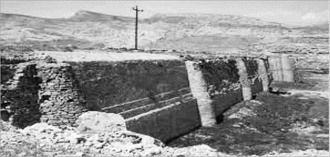
Figure 4. Akhlamad historical dam.
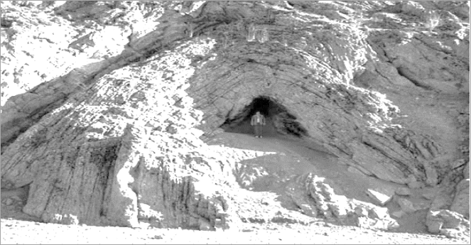
Figure 5. Akhlamad Cave.
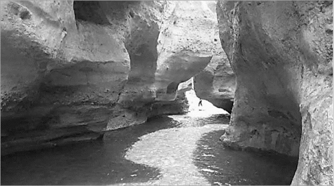
Figure 6. Ajenneh Valley.
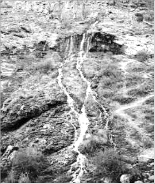
Figure 7. Bidestan waterfall.
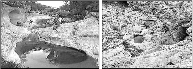
Figure 8. Calcareous holes (dolines).
Information

